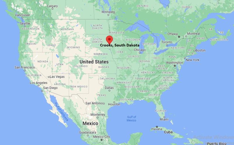
Where is Crooks Located? - Crooks is a city located in the Minnehaha County of South Dakota, United States. Crooks lies between 43.64509 Degrees North latitudes and -96.8183 Degrees West longitudes.
Location Map of Crooks, South Dakota
Crooks Map, South Dakota, USA
Where is Crooks Located?
Crooks is a city located in the Minnehaha County of South Dakota , United States . Crooks lies between 43.64509 Degrees North latitudes and -96.8183 Degrees West longitudes. According to 2020 U.S.census, the population of Crooks city is 1362 people and the city has a total area of 0.769 sq mi. The city has numerous parks and recreational facilities.
Most Viewed US Maps
Crooks, South Dakota Quick Facts
Nearby Cities to Crooks, South Dakota
Sioux Falls, South Dakota — 10 mi Southeast
Brandon, South Dakota — 8 mi East
Hartford, South Dakota — 6 mi West
Colton, South Dakota — 7 mi Northwest
Renner, South Dakota — 12 mi East
Humboldt, South Dakota — 15 mi West
Valley Springs, South Dakota — 14 mi Southeast
Garretson, South Dakota — 18 mi Northeast
Tea, South Dakota — 12 mi South
Lennox, South Dakota — 20 mi Southwest
Crooks, South Dakota Climate and Weather Overview
Month Avg High (°F) Avg Low (°F) Avg Rainfall (in)
January 25 7 0.6 April 57 34 2.1 July 85 63 3.0 October 60 38 1.5 Annual 55 35 25.0
Climate Attribute Value
Climate Classification (Köppen) Humid Continental (Dfa) Annual Rainfall ~23–26 inches Annual Snowfall ~35–45 inches Annual Sunshine Days ~200 days Tornado Risk Moderate
Driving Distances from Crooks, South Dakota
City State Distance (mi) Approx. Drive Time
Sioux Falls SD 10 15 min Brandon SD 8 10 min Hartford SD 6 10 min Colton SD 7 10 min Tea SD 12 15 min Lennox SD 20 25 min Humboldt SD 15 20 min Garretson SD 18 25 min Worthing SD 22 30 min Brookings SD 55 1 hr
Transportation and Connectivity in Crooks, South Dakota
Mode Details
Airport Sioux Falls Regional Airport (FSD) Port None (inland city) Major Highways I-29 (nearby), SD-115, SD-19 Rail/Amtrak Nearest Amtrak service via Sioux Falls region (no direct stop) Local Transit Limited rural transit; Sioux Falls Metro Transit nearby
I-29 — major north-south interstate connecting Sioux Falls with North Dakota and Iowa
SD-115 — connects Crooks area to Sioux Falls and surrounding suburbs
SD-19 — regional route linking nearby small towns and rural communities
Key Landmarks and Places to Visit in Crooks, South Dakota
Landmark Name Type
Sioux Empire Fairgrounds (nearby Sioux Falls) Event Grounds Good Earth State Park (nearby) State Park Great Bear Recreation Park (nearby Sioux Falls) Recreation Park Falls Park (Sioux Falls) Natural / City Park Big Sioux River Greenway Nature Trail Downtown Sioux Falls District Entertainment District Wild Water West Waterpark (nearby) Water Park Washington Pavilion (Sioux Falls) Arts & Science Center
Places to Visit in Crooks, South Dakota
Landmark Name Type
Old Crooks Downtown Area Small Town Center Sioux Falls SculptureWalk Public Art Walk Cathedral of Saint Joseph (Sioux Falls) Historic Church Butterfly House & Aquarium (nearby) Family Attraction Old Courthouse Museum (Sioux Falls) History Museum Lake Lorraine (Sioux Falls) Recreation Lake Seratoma Park (Sioux Falls) City Park Palisades State Park (nearby Garretson) State Park
Colleges and Universities in Crooks, South Dakota
Institution Name Type Level Notable For
Augustana University (nearby Sioux Falls) Private University Liberal arts & sciences University of Sioux Falls Private University Business & education programs South Dakota State University (regional) Public University Agriculture & engineering
Waterbodies in Crooks, South Dakota
Big Sioux River, Skunk Creek, Split Rock Creek, Wall Lake (regional), Sioux River tributaries
Golf Courses in Crooks, South Dakota
Elmwood Golf Course (Sioux Falls), Brandon Golf Course (nearby), Kuehn Park Golf Course (Sioux Falls), Prairie Green Golf Course (Sioux Falls)
Crooks, South Dakota - Key Historical Facts
Crooks was established in the early 20th century as a small agricultural settlement in Minnehaha County.
The city grew slowly at first due to its proximity to Sioux Falls and surrounding farmland.
It was named after an early railroad or land developer associated with the region.
Rail and farming activity played an important role in its early economic development.
Modern growth has been driven by suburban expansion from Sioux Falls.
Today it is considered part of the Sioux Falls metropolitan area with a small-town community feel.
References
More South Dakota Maps & Info
Location Map of South Dakota Cities
Popular US Cities
About USA
US Counties
World Countries
World Cup 2026