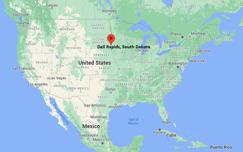
Where is Dell Rapids Located? - Dell Rapids is a city located in the Minnehaha County of South Dakota, United States. Dell Rapids lies between 44.9901194 Degrees North latitudes and 123.0262077 Degrees West longitudes.
Location Map of Dell Rapids, South Dakota
Dell Rapids Map, South Dakota, USA
Where is Dell Rapids?: The Google Map showing the location of Dell Rapids in the U.S. state of South Dakota.
Where is Dell Rapids Located?
Dell Rapids is a city located in the Minnehaha County of South Dakota, United States. Dell Rapids lies between 44.9901194 Degrees North latitudes and 123.0262077 Degrees West longitudes. According to 2020 U.S.census, the population of Dell Rapids city is 3996 people and the city has a total area of 2.13 sq mi. The city has numerous parks and recreational facilities.
Dell Rapids, South Dakota Climate and Weather Overview
Month
Avg High (°F)
Avg Low (°F)
Avg Rainfall (in)
January
25
7
0.6
April
58
34
2.3
July
84
62
3.6
October
61
38
1.8
Annual
57
35
27.4
Climate Attribute
Details
Climate Classification (Köppen)
Hot-Summer Humid Continental (Dfa)
Annual Rainfall
About 27 inches
Annual Sunshine Days
Approximately 212 days
Hurricane/Tornado Risk
No hurricane risk; moderate tornado risk
Snowfall
About 41 inches annually
Driving Distances from Dell Rapids, South Dakota
City
State
Distance (mi)
Approx. Drive Time
Baltic
South Dakota
10
12 min
Garretson
South Dakota
13
15 min
Colton
South Dakota
16
20 min
Crooks
South Dakota
18
22 min
Hartford
South Dakota
22
25 min
Sioux Falls
South Dakota
23
28 min
Brandon
South Dakota
24
30 min
Madison
South Dakota
34
40 min
Pipestone
Minnesota
39
45 min
Brookings
South Dakota
48
55 min
Transportation and Connectivity in Dell Rapids, South Dakota
Transportation
Details
Airport Name
Sioux Falls Regional Airport
IATA Code
FSD
Port
No commercial port
Major Highways
Interstate 29 (nearby), South Dakota Highway 115, South Dakota Highway 77
Train/Amtrak Service
No passenger rail service
Local Bus/Transit Service
Regional transportation services available through Sioux Falls area providers
South Dakota Highway 115 - Main route connecting Dell Rapids with Sioux Falls and nearby communities.
South Dakota Highway 77 - Regional highway linking the city with eastern South Dakota towns and Interstate 90.
Interstate 29 - Located west of the city, providing direct north-south access to Sioux Falls, Brookings, Fargo, and Sioux City.
County Road 106 - Serves local traffic and agricultural areas surrounding Dell Rapids.
Key Landmarks and Places to Visit in Dell Rapids, South Dakota
Landmark Name
Type
Dell Rapids City Park
City Park
Sioux Quartzite River Walk
Scenic Walkway
Dells Theatre
Historic Theater
Dell Rapids Museum
History Museum
Big Sioux River Falls
Natural Attraction
Rock Park
City Park
Tumbled Park
Recreation Park
Great Bear Ski Valley
Outdoor Recreation Area
Palisades State Park
State Park
Catfish Bay Water Ski Park
Water Recreation Park
Colleges and Universities in Dell Rapids, South Dakota
Institution Name
Type
Level
Notable For
University of Sioux Falls
Private
University
Liberal arts and business programs
Southeast Technical College
Public
Community College
Career and technical education
Augustana University
Private
University
Liberal arts education
South Dakota State University
Public
University
Agriculture and engineering programs
Dell Rapids School District 49-3
Public
K-12 District
Public education system
Waterbodies in Dell Rapids, South Dakota
Big Sioux River, Silver Creek, Split Rock Creek, Skunk Creek, Lake Madison, Wall Lake, Beaver Creek, Brant Lake
Golf Courses in Dell Rapids, South Dakota
Rock River Golf & Country Club, Willow Run Golf Course, Elmwood Golf Course, Prairie Green Golf Course, Bakker Crossing Golf Course, Brandon Golf Course
Dell Rapids, South Dakota - Key Historical Facts
Dell Rapids was founded in the 1870s after quartzite quarries and the arrival of the railroad encouraged settlement in eastern South Dakota.
The city became known as the "Little City with the Big Attractions" because of its distinctive pink Sioux quartzite buildings and scenic river landscape.
Local quartzite was widely used in the construction of homes, churches, schools, and commercial buildings that still define the city's historic character.
The Big Sioux River played an important role in powering early mills and supporting the community's economic development.
Dell Rapids developed into a regional center for agriculture, stone quarrying, and local commerce throughout the late 19th and early 20th centuries.
Today, the city is recognized for its historic downtown, outdoor recreation, well-preserved quartzite architecture, and welcoming small-town atmosphere.