
Where is Brookings Located? - Brookings is a city located in the Brookings County of South Dakota, United States. Brookings lies between 44.30562 Degrees North latitudes and -96.7914 Degrees West longitudes.
Location Map of Brookings, South Dakota
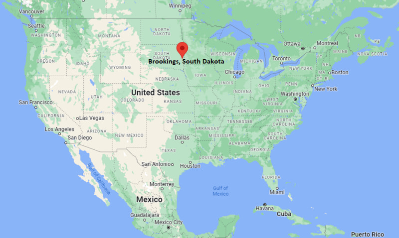
Brookings Map, South Dakota, USA
Where is Brookings?: The Google Map showing the location of Brookings in the U.S. state of South Dakota.
Where is Brookings Located?
Brookings is a city located in the Brookings County of South Dakota, United States. Brookings lies between 44.30562 Degrees North latitude and -96.7914 Degrees West longitude. According to the 2020 U.S. Census, the population of Brookings city is 23,377 people and the city has a total area of 13.54 sq mi. The city has numerous parks and recreational facilities.
Most Viewed US Maps
| USA Sttae Map | USA Region Map | USA Road Map |
| USA County Map | Where is USA in World Map? | US ZIP Code Map |
| USA Time Zones Map | US State and Capitals Map | USA Physical Map |
Find 4,400+ U.S. Cities by State - Explore Their Locations and Get Detailed Information
Brookings, South Dakota Quick Facts
| Fact | Details |
|---|---|
| City | Brookings |
| County | Brookings County |
| State | South Dakota |
| State Capital | Pierre |
| Country | United States |
| US Region | Midwest |
| Latitude | 44.30562 N |
| Longitude | -96.7914 W |
| Elevation | 1,640 ft (500 m) |
| Land Area | approx. 13.0 sq mi |
| Water Area | approx. 0.1 sq mi |
| Total Area | approx. 13.54 sq mi |
| Population (Census 2020) | 24,415 |
| Population Density | Approximately 1,880 per sq mi |
| ZIP Code | 57006 |
| Area Code | 605 |
| Time Zone Standard | Central Standard Time (CST, UTC-6) |
| Time Zone Daylight | Central Daylight Time (CDT, UTC-5) |
| Currency | United States Dollar (USD) |
| FIPS Code | 46-07580 |
| Congressional District | South Dakota's At-Large District |
Nearby Cities and Towns to Brookings, South Dakota
- Volga, South Dakota - 10 mi West
- Bruce, South Dakota - 14 mi North
- White, South Dakota - 12 mi South
- Arlington, South Dakota - 25 mi Northwest
- Estelline, South Dakota - 20 mi Northeast
- Sioux Falls, South Dakota - 55 mi Southwest
- Watertown, South Dakota - 50 mi North
- Flandreau, South Dakota - 25 mi Southeast
- Madison, South Dakota - 30 mi Southwest
- Hendricks, Minnesota - 35 mi Southeast
Brookings, South Dakota Climate and Weather Overview
| Month | Avg High (°F) | Avg Low (°F) | Avg Precipitation (in) |
|---|---|---|---|
| January | 23 | 5 | 0.6 |
| April | 55 | 33 | 1.8 |
| July | 84 | 61 | 3.2 |
| October | 58 | 38 | 1.5 |
| Annual | 56 | 36 | 23.5 |
| Climate Attribute | Details |
|---|---|
| Climate Classification | Humid Continental (Dfb) |
| Annual Precipitation | Approximately 23.5 inches |
| Annual Snowfall | 35–45 inches |
| Severe Weather Risk | High - blizzards, thunderstorms, tornado risk |
| Annual Sunshine Days | About 200 days |
Driving Distances from Brookings, South Dakota
| City | State | Distance (mi) | Approx. Drive Time |
|---|---|---|---|
| Volga | South Dakota | 10 | 12 min |
| Sioux Falls | South Dakota | 55 | 55 min |
| Watertown | South Dakota | 50 | 55 min |
| Madison | South Dakota | 30 | 35 min |
| Flandreau | South Dakota | 25 | 30 min |
| Arlington | South Dakota | 25 | 30 min |
| Huron | South Dakota | 85 | 1 hr 30 min |
| Mitchell | South Dakota | 90 | 1 hr 35 min |
| Minneapolis | Minnesota | 200 | 3 hr 20 min |
| Omaha | Nebraska | 230 | 3 hr 40 min |
Transportation and Connectivity in Brookings, South Dakota
| Transportation | Details |
|---|---|
| Nearest Airport | Brookings Regional Airport |
| IATA Code | BKX |
| Nearest Major Airport | Sioux Falls Regional Airport |
| Major Highways | Interstate 29, U.S. Route 14, South Dakota Highway 30 |
| Rail Service | Freight rail (BNSF Railway) |
| Local Transit | Brookings Area Transit (BAT) bus service |
- I-29 connects Brookings directly to Sioux Falls and North Dakota.
- U.S. Route 14 runs east–west through the city and links regional communities.
- Brookings Regional Airport (BKX) serves general aviation and limited regional flights.
- Sioux Falls Regional Airport is the nearest major commercial airport.
Key Landmarks and Places to Visit in Brookings, South Dakota
| Landmark | Type |
|---|---|
| McCrory Gardens | Botanical Garden |
| South Dakota Art Museum | Museum |
| Children's Museum of South Dakota | Interactive Museum |
| Hillcrest Aquatic Center | Recreation Center |
| Brookings County Museum | History Museum |
| Fishback Soccer Complex | Sports Complex |
| Larson Ice Center | Ice Arena |
| Edgebrook Golf Course | Golf Course |
| Swiftel Center | Event Arena |
| Hillcrest Park | City Park |
Colleges and Universities in Brookings, South Dakota
| Institution | Type | Level | Notable For |
|---|---|---|---|
| South Dakota State University | Public | Research University | Agriculture, engineering, nursing, pharmacy |
| University of South Dakota (regional access) | Public | Research University | Law, medicine, health sciences, liberal arts |
| Dakota State University (regional) | Public | University | Cybersecurity, IT, computer science |
| Southeast Technical College | Public | Technical College | Career training and applied sciences |
| Augustana University (regional) | Private | University | Liberal arts, health sciences, education |
| Presentation College (historical regional reference) | Private | College | Nursing and healthcare programs |
Waterbodies in Brookings, South Dakota
Medary Creek, Deer Creek, Big Sioux River (regional), Lake Campbell (nearby), Lake Sinai (regional), Oakwood Lakes (regional recreation area), Lake Madison (nearby), Volga Lake (regional), Sioux River watershed, Pipestone Creek.
Golf Courses in Brookings, South Dakota
Edgebrook Golf Course, The Lakes Golf Course (nearby Wentworth), River Ridge Golf Course (nearby Garretson), Madison Golf and Country Club, Lakeview Golf Course, Elmwood Golf Course (regional), Prairie Green Golf Course (Sioux Falls), Central Valley Golf Course.
Brookings, South Dakota - Key Historical Facts
- Brookings was founded in the late 19th century during railroad expansion across Dakota Territory.
- The city was named after Wilmot Wood Brookings, an early settler and territorial leader.
- South Dakota State University was established in 1881, becoming a major driver of the city’s growth.
- The railroad and agriculture industries shaped early economic development in the region.
- Brookings grew steadily as an education and research hub in eastern South Dakota.
- Today, it is known for higher education, innovation, and a strong agricultural economy.
References
More South Dakota Maps & Info
- Where is Aberdeen
- Where is Belle Fourche
- Where is Beresford
- Where is Blackhawk
- Where is Box Elder
- Where is Brandon
- Where is Brookings
- Where is Canton
- Where is Chamberlain
- Where is Colonial Pine Hills
- Where is Crooks
- Where is Custer
- Where is Dell Rapids
- Where is Elk Point
- Where is Flandreau
- Where is Fort Pierre
- Where is Harrisburg
- Where is Hartford
- Where is Hot Springs
- Where is Huron
- Where is Lead
- Where is Lennox
- Where is Milbank
- Where is Mitchell
- Where is Mobridge
- Where is North Eagle Butte
- Where is North Sioux City
- Where is North Spearfish
- Where is Parkston
- Where is Pierre
- Where is Pine Ridge
- Where is Rapid City
- Where is Rapid Valley
- Where is Redfield
- Where is Rosebud
- Where is Sioux Falls
- Where is Sisseton
- Where is Spearfish
- Where is Sturgis
- Where is Summerset
- Where is Tea
- Where is Vermillion
- Where is Volga
- Where is Wagner
- Where is Watertown
- Where is Webster
- Where is Winner
- Where is Yankton