Written and Fact-checked by Whereig Editors, Reviewed by Mukesh Kumar| Last Updated On: May 11, 2026
Map of Brookings County - Brookings County is a county located in the U.S. state of South Dakota. Brookings County Map showing cities, highways, important places and water bodies. Get Where is Brookings County located in the map, major cities in Brookings county, population, areas, and places of interest.
Map of Brookings County, South Dakota
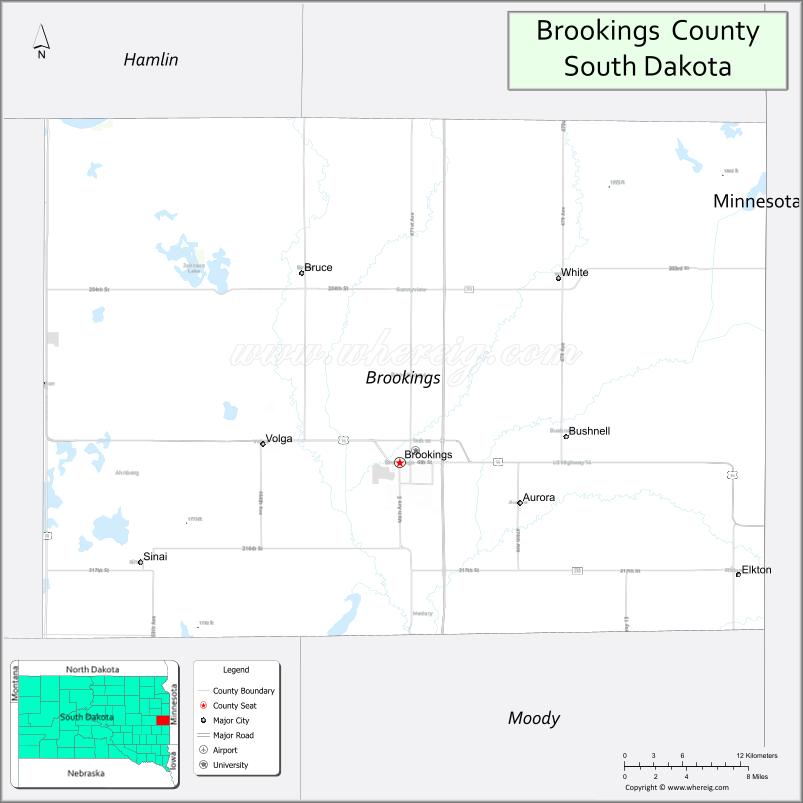
About Brookings County Map, South Dakota: The map showing the county boundary, county seat, major cities, highways, water bodies and neighbouring counties.
More South Dakota Maps & Info
About Brookings County, South Dakota
Brookings County is a county located in the U.S. state of South Dakota. It's county seat is Brookings. As per 2020 census, the population of Brookings County is 34639 people and population density is square miles. According to the United States Census Bureau, the county has a total area of 794 sq mi (2,056 km2). Brookings County was established on 1862.
Brookings County Facts
| Continent | North America |
| Country | United States |
| State | South Dakota |
| County Seat | Brookings |
| Largest City/Town | Brookings |
| Established | 1862 |
| Total Area | 807 sq mi (2,090 sq km) |
| Land Area | 792 sq mi (2,051 sq km) |
| Water Area | 15 sq mi (39 sq km) |
| Population | 34,375 (Census 2020) |
| Population Density | 43.4 people per sq mi |
| Time Zone | Central Time Zone (CT) |
| Major Highways | Interstate 29, US 14, SD 324 |
| Major Rivers | Big Sioux River |
| Neighboring Counties | Deuel County, Hamlin County, Kingsbury County, Lake County, Moody County |
| Famous For | South Dakota State University, agriculture, research, education, college athletics |
| Top Attractions | South Dakota State University, McCrory Gardens, Children's Museum of South Dakota, Daktronics |
| Official Website | Official Website |
About Brookings County, South Dakota
Brookings County is located in eastern South Dakota in the United States and was established in 1862. The county seat and largest city is Brookings. The county is known for higher education, agricultural research, technology industries, and being home to South Dakota State University.
Cities and Towns in Brookings County, South Dakota
| City/Town | Population (Census 2020) | Latitude & Longitude |
|---|---|---|
| Brookings (county seat) | 24,509 | 44.3114°N, 96.7984°W |
| Volga | 2,113 | 44.3230°N, 96.9265°W |
| Aurora | 1,058 | 44.2891°N, 96.6840°W |
| White | 448 | 44.4436°N, 96.6506°W |
| Elkton | 736 | 44.2369°N, 96.4862°W |
| Bruce | 204 | 44.4402°N, 96.8862°W |
| Bushnell | 13 | 44.3275°N, 96.5753°W |
Golf Courses in Brookings County, South Dakota
| Golf Course | Location | Latitude & Longitude |
|---|---|---|
| Brookings Country Club | Brookings | 44.2968°N, 96.7724°W |
| Edgebrook Golf Course | Brookings | 44.3221°N, 96.7742°W |
| Volga Golf Course | Volga | 44.3246°N, 96.9255°W |
| Lake Region Golf Club nearby | Arlington | 44.3642°N, 97.1315°W |
Roads and Highways in Brookings County, South Dakota
Major highways connect the county to Sioux Falls, North Dakota, and Minnesota.
- Interstate 29 - major north-south interstate linking Brookings with Fargo and Sioux Falls
- US Highway 14 - east-west route through Brookings and eastern South Dakota
- South Dakota Highway 324 - connector route serving local transportation needs
What are Neighboring Counties of Brookings County
- Deuel County (north)
- Hamlin County (west)
- Kingsbury County (southwest)
- Lake County (south)
- Moody County (southeast)
What are the Top Attractions in Brookings County, South Dakota
The county offers a mix of educational, recreational, and cultural attractions.
- South Dakota State University - major public university known for agriculture, engineering, and athletics
- McCrory Gardens - botanical gardens and arboretum operated by SDSU
- Children's Museum of South Dakota - interactive educational attraction for families
- Daktronics headquarters - leading electronic scoreboard and display technology company
- South Dakota Art Museum - regional art collections and exhibitions
- Edgebrook Golf Course - public golf destination in Brookings
- Brookings Summer Arts Festival - annual arts and cultural event
- Nickelodeon Universe nearby in Minnesota region - family entertainment attraction
- Oakwood Lakes State Park nearby - camping, fishing, and boating destination
- Brookings County Outdoor Adventure Center - recreation and environmental education
- Downtown Brookings - restaurants, shopping, and entertainment district
- SDSU athletic events - college football and basketball attractions
- Big Sioux River recreation areas - trails, fishing, and wildlife viewing
- Local breweries and dining venues - growing food and beverage scene
What is the Distance from Brookings County to Nearby Cities
The following distances are measured by road (driving).
- Brookings to Sioux Falls (Minnehaha County), South Dakota - 57 mi (92 km)
- Brookings to Watertown (Codington County), South Dakota - 53 mi (85 km)
- Brookings to Huron (Beadle County), South Dakota - 91 mi (146 km)
- Brookings to Fargo (Cass County), North Dakota - 191 mi (307 km)
- Brookings to Minneapolis (Hennepin County), Minnesota - 222 mi (357 km)
- Brookings to Pierre (Hughes County), South Dakota - 198 mi (319 km)
- Brookings to Omaha (Douglas County), Nebraska - 210 mi (338 km)
- Brookings to Aberdeen (Brown County), South Dakota - 122 mi (196 km)
- Brookings to Rapid City (Pennington County), South Dakota - 404 mi (650 km)
- Brookings to Sioux City (Woodbury County), Iowa - 128 mi (206 km)
- Brookings to Bismarck (Burleigh County), North Dakota - 343 mi (552 km)
- Brookings to Kansas City (Jackson County), Missouri - 423 mi (681 km)
FAQs about Brookings County
Brookings County is located in eastern South Dakota near the Minnesota border.
Brookings County had a population of 34,375 according to the 2020 United States Census.
Brookings County is known for South Dakota State University, agricultural research, education, and technology industries.
The major highways include Interstate 29, US Highway 14, and South Dakota Highway 324.
Yes, Brookings County has golf facilities including Brookings Country Club and Edgebrook Golf Course.
References
- QuickFacts - U.S. Census Bureau
- United States Census Bureau
- United States Geological Survey (USGS)
- National Geodetic Survey
- Official Website
- Aurora County Map
- Beadle County Map
- Bennett County Map
- Bon Homme County Map
- Brookings County Map
- Brown County Map
- Brule County Map
- Buffalo County Map
- Butte County Map
- Campbell County Map
- Charles Mix County Map
- Clark County Map
- Clay County Map
- Codington County Map
- Corson County Map
- Custer County Map
- Davison County Map
- Day County Map
- Deuel County Map
- Dewey County Map
- Douglas County Map
- Edmunds County Map
- Fall River County Map
- Faulk County Map
- Grant County Map
- Gregory County Map
- Haakon County Map
- Hamlin County Map
- Hand County Map
- Hanson County Map
- Harding County Map
- Hughes County Map
- Hutchinson County Map
- Hyde County Map
- Jackson County Map
- Jerauld County Map
- Jones County Map
- Kingsbury County Map
- Lake County Map
- Lawrence County Map
- Lincoln County Map
- Lyman County Map
- McCook County Map
- McPherson County Map
- Marshall County Map
- Meade County Map
- Mellette County Map
- Miner County Map
- Minnehaha County Map
- Moody County Map
- Oglala Lakota County Map
- Pennington County Map
- Perkins County Map
- Potter County Map
- Roberts County Map
- Sanborn County Map
- Spink County Map
- Stanley County Map
- Sully County Map
- Todd County Map
- Tripp County Map
- Turner County Map
- Union County Map
- Walworth County Map
- Yankton County Map
- Ziebach County Map
- Alabama Counties
- Alaska boroughs
- Arizona Counties
- Arkansas Counties
- California County Map
- Colorado Counties
- Connecticut Counties
- Delaware Counties
- Florida County Map
- Georgia County Map
- Hawaii Counties
- Idaho Counties
- Illinois Counties
- Indiana Counties
- Iowa Counties
- Kansas Counties
- Kentucky Counties
- Louisiana Counties
- Maine Counties
- Maryland Counties
- Massachusetts Counties
- Michigan County Map
- Minnesota Counties
- Mississippi Counties
- Missouri Counties
- Montana Counties
- Nebraska Counties
- Nevada Counties
- New York Counties
- New Hampshire Counties
- New Jersey Counties
- New Mexico Counties
- North Carolina Counties
- North Dakota Counties
- Ohio County Map
- Oklahoma Counties
- Oregon Counties
- Pennsylvania Counties
- Rhode Island Counties
- South Carolina Counties
- South Dakota Counties
- Map of Tennessee
- Texas County Map
- Utah Counties
- Vermont Counties
- Virginia Counties
- Washington Counties
- West Virginia Counties
- Wisconsin Counties
- Wyoming Counties