Written and Fact-checked by Whereig Editors, Reviewed by Mukesh Kumar| Last Updated On: May 11, 2026
Map of Custer County - Custer County is a county located in the U.S. state of South Dakota. Custer County Map showing cities, highways, important places and water bodies. Get Where is Custer County located in the map, major cities in Custer county, population, areas, and places of interest.
Map of Custer County, South Dakota
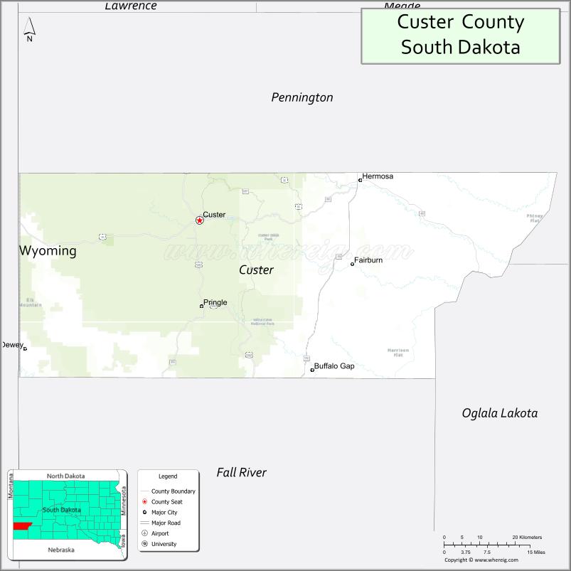
About Custer County Map, South Dakota: The map showing the county boundary, county seat, major cities, highways, water bodies and neighbouring counties.
More South Dakota Maps & Info
About Custer County, South Dakota
Custer County is a county located in the U.S. state of South Dakota. It's county seat is Custer. As per 2020 census, the population of Custer County is 8609 people and population density is square miles. According to the United States Census Bureau, the county has a total area of 1,558 sq mi (4,035 km2). Custer County was established on 1875.
Custer County Facts
| Continent | North America |
| Country | United States |
| State | South Dakota |
| County Seat | Custer |
| Largest City/Town | Custer |
| Established | 1875 |
| Total Area | 1,557 sq mi (4,033 sq km) |
| Land Area | 1,554 sq mi (4,024 sq km) |
| Water Area | 3 sq mi (9 sq km) |
| Population | 8,318 (Census 2020) |
| Population Density | 5.4 people per sq mi |
| Time Zone | Mountain Time Zone (MT) |
| Major Highways | US 16, US 385, SD 36, SD 87 |
| Major Rivers | French Creek |
| Neighboring Counties | Fall River County, Pennington County, Oglala Lakota County, Weston County (WY), Niobrara County (WY) |
| Famous For | Black Hills, Custer State Park, Mount Rushmore nearby, outdoor recreation |
| Top Attractions | Custer State Park, Crazy Horse Memorial, Needles Highway, Jewel Cave National Monument |
| Official Website | Official Website |
About Custer County, South Dakota
Custer County is located in southwestern South Dakota in the United States and was established in 1875. The county seat and largest city is Custer. The county is known for the Black Hills, scenic mountain landscapes, wildlife, tourism, and outdoor recreation destinations including Custer State Park.
Cities and Towns in Custer County, South Dakota
| City/Town | Population (Census 2020) | Latitude & Longitude |
|---|---|---|
| Custer (county seat) | 1,919 | 43.7667°N, 103.5988°W |
| Buffalo Gap | 126 | 43.4908°N, 103.3157°W |
| Hermosa nearby | 398 | 43.8397°N, 103.1885°W |
| Pringle | 112 | 43.6086°N, 103.5921°W |
| Fairburn | 85 | 43.6928°N, 103.2146°W |
| Hot Springs nearby | 3,395 | 43.4316°N, 103.4744°W |
Golf Courses in Custer County, South Dakota
| Golf Course | Location | Latitude & Longitude |
|---|---|---|
| Rocky Knolls Golf Course | Custer | 43.7605°N, 103.6052°W |
| Southern Hills Golf Course nearby | Hot Springs | 43.4329°N, 103.4832°W |
| Hart Ranch Golf Club nearby | Rapid City | 43.9778°N, 103.3112°W |
| Elkhorn Ridge Golf Club nearby | Spearfish | 44.4374°N, 103.8145°W |
Roads and Highways in Custer County, South Dakota
Major highways connect the county to the Black Hills region, Wyoming, and western South Dakota attractions.
- US Highway 16 - scenic route through the Black Hills connecting Rapid City and Wyoming
- US Highway 385 - major north-south route through the Black Hills National Forest
- South Dakota Highway 36 - regional highway serving recreation and tourism destinations
- South Dakota Highway 87 - scenic route including the Needles Highway
What are Neighboring Counties of Custer County
- Pennington County (north)
- Fall River County (south)
- Oglala Lakota County (east)
- Weston County, Wyoming (west)
- Niobrara County, Wyoming (southwest)
What are the Top Attractions in Custer County, South Dakota
The county offers a mix of mountain scenery, wildlife, and world-famous tourist attractions.
- Custer State Park - one of the largest state parks in the United States with bison herds and scenic drives
- Crazy Horse Memorial - massive mountain carving honoring Lakota leader Crazy Horse
- Needles Highway - scenic mountain road featuring tunnels and granite spires
- Jewel Cave National Monument - one of the longest cave systems in the world
- Black Hills National Forest - hiking, camping, fishing, and wildlife viewing destination
- Mount Rushmore National Memorial nearby - iconic presidential mountain sculpture
- Sylvan Lake - boating, kayaking, hiking, and photography hotspot
- Wildlife Loop Road - famous for viewing bison, elk, deer, and wild burros
- Wind Cave National Park nearby - cave tours and prairie wildlife habitats
- Historic downtown Custer - shops, restaurants, and western heritage attractions
- Mickelson Trail - biking and hiking trail through the Black Hills
- French Creek recreation areas - fishing and scenic outdoor destinations
- Rock climbing and hiking trails - outdoor adventure throughout the Black Hills
- Annual Buffalo Roundup - major tourism and cultural event in Custer State Park
What is the Distance from Custer County to Nearby Cities
The following distances are measured by road (driving).
- Custer to Rapid City (Pennington County), South Dakota - 40 mi (64 km)
- Custer to Hot Springs (Fall River County), South Dakota - 27 mi (43 km)
- Custer to Deadwood (Lawrence County), South Dakota - 67 mi (108 km)
- Custer to Spearfish (Lawrence County), South Dakota - 83 mi (134 km)
- Custer to Chadron (Dawes County), Nebraska - 83 mi (134 km)
- Custer to Casper (Natrona County), Wyoming - 217 mi (349 km)
- Custer to Pierre (Hughes County), South Dakota - 210 mi (338 km)
- Custer to Sioux Falls (Minnehaha County), South Dakota - 360 mi (579 km)
- Custer to Denver (Denver County), Colorado - 382 mi (615 km)
- Custer to Billings (Yellowstone County), Montana - 329 mi (529 km)
- Custer to Bismarck (Burleigh County), North Dakota - 370 mi (595 km)
- Custer to Minneapolis (Hennepin County), Minnesota - 639 mi (1,028 km)
FAQs about Custer County
Custer County is located in southwestern South Dakota in the Black Hills region.
Custer County had a population of 8,318 according to the 2020 United States Census.
Custer County is known for Custer State Park, the Black Hills, outdoor recreation, and scenic tourism attractions.
The major highways include US Highway 16, US Highway 385, South Dakota Highway 36, and Highway 87.
Yes, Custer County has golf facilities including Rocky Knolls Golf Course and nearby Black Hills golf clubs.
References
- QuickFacts - U.S. Census Bureau
- United States Census Bureau
- United States Geological Survey (USGS)
- National Geodetic Survey
- Official Website
- Aurora County Map
- Beadle County Map
- Bennett County Map
- Bon Homme County Map
- Brookings County Map
- Brown County Map
- Brule County Map
- Buffalo County Map
- Butte County Map
- Campbell County Map
- Charles Mix County Map
- Clark County Map
- Clay County Map
- Codington County Map
- Corson County Map
- Custer County Map
- Davison County Map
- Day County Map
- Deuel County Map
- Dewey County Map
- Douglas County Map
- Edmunds County Map
- Fall River County Map
- Faulk County Map
- Grant County Map
- Gregory County Map
- Haakon County Map
- Hamlin County Map
- Hand County Map
- Hanson County Map
- Harding County Map
- Hughes County Map
- Hutchinson County Map
- Hyde County Map
- Jackson County Map
- Jerauld County Map
- Jones County Map
- Kingsbury County Map
- Lake County Map
- Lawrence County Map
- Lincoln County Map
- Lyman County Map
- McCook County Map
- McPherson County Map
- Marshall County Map
- Meade County Map
- Mellette County Map
- Miner County Map
- Minnehaha County Map
- Moody County Map
- Oglala Lakota County Map
- Pennington County Map
- Perkins County Map
- Potter County Map
- Roberts County Map
- Sanborn County Map
- Spink County Map
- Stanley County Map
- Sully County Map
- Todd County Map
- Tripp County Map
- Turner County Map
- Union County Map
- Walworth County Map
- Yankton County Map
- Ziebach County Map
- Alabama Counties
- Alaska boroughs
- Arizona Counties
- Arkansas Counties
- California County Map
- Colorado Counties
- Connecticut Counties
- Delaware Counties
- Florida County Map
- Georgia County Map
- Hawaii Counties
- Idaho Counties
- Illinois Counties
- Indiana Counties
- Iowa Counties
- Kansas Counties
- Kentucky Counties
- Louisiana Counties
- Maine Counties
- Maryland Counties
- Massachusetts Counties
- Michigan County Map
- Minnesota Counties
- Mississippi Counties
- Missouri Counties
- Montana Counties
- Nebraska Counties
- Nevada Counties
- New York Counties
- New Hampshire Counties
- New Jersey Counties
- New Mexico Counties
- North Carolina Counties
- North Dakota Counties
- Ohio County Map
- Oklahoma Counties
- Oregon Counties
- Pennsylvania Counties
- Rhode Island Counties
- South Carolina Counties
- South Dakota Counties
- Map of Tennessee
- Texas County Map
- Utah Counties
- Vermont Counties
- Virginia Counties
- Washington Counties
- West Virginia Counties
- Wisconsin Counties
- Wyoming Counties