Written and Fact-checked by Whereig Editors, Reviewed by Mukesh Kumar| Last Updated On: May 11, 2026
Map of Hughes County - Hughes County is a county located in the U.S. state of South Dakota. Hughes County Map showing cities, highways, important places and water bodies. Get Where is Hughes County located in the map, major cities in Hughes county, population, areas, and places of interest.
Map of Hughes County, South Dakota
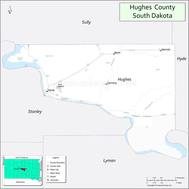
About Hughes County Map, South Dakota: The map showing the county boundary, county seat, major cities, highways, water bodies and neighbouring counties.
More South Dakota Maps & Info
About Hughes County, South Dakota
Hughes County is a county located in the U.S. state of South Dakota. It's county seat is Pierre. As per 2020 census, the population of Hughes County is 17694 people and population density is square miles. According to the United States Census Bureau, the county has a total area of 741 sq mi (1,919 km2). Hughes County was established on 1880.
Hughes County Facts
| Continent | North America |
| Country | United States |
| State | South Dakota |
| County Seat | Pierre |
| Largest City/Town | Pierre |
| Established | 1873 |
| Total Area | 814 sq mi (2,108 sq km) |
| Land Area | 741 sq mi (1,919 sq km) |
| Water Area | 73 sq mi (189 sq km) |
| Population | 17,765 (Census 2020) |
| Population Density | 24.0 people per sq mi |
| Time Zone | Central Time Zone (CT) |
| Major Highways | US 14, US 83, SD 34 |
| Major Rivers | Missouri River |
| Neighboring Counties | Sully County, Hyde County, Stanley County, Lyman County |
| Famous For | South Dakota State Capitol, Missouri River, Lake Oahe recreation, government center |
| Top Attractions | South Dakota State Capitol, Oahe Dam, Missouri River recreation, Cultural Heritage Center |
| Official Website | Official Website |
About Hughes County, South Dakota
Hughes County is located in central South Dakota in the United States and was established in 1873. The county seat and largest city is Pierre, which also serves as the capital city of South Dakota. The county is known for government institutions, Missouri River recreation, outdoor activities, and scenic prairie landscapes.
Cities and Towns in Hughes County, South Dakota
| City/Town | Population (Census 2020) | Latitude & Longitude |
|---|---|---|
| Pierre (county seat) | 14,091 | 44.3683°N, 100.3510°W |
| Blunt | 354 | 44.5291°N, 99.9890°W |
| Harrold | 112 | 44.5258°N, 99.7401°W |
| Fort Pierre nearby | 2,404 | 44.3650°N, 100.3735°W |
| Onida nearby | 698 | 44.7086°N, 100.0673°W |
| Okobojo nearby | 18 | 44.6820°N, 99.9942°W |
Golf Courses in Hughes County, South Dakota
| Golf Course | Location | Latitude & Longitude |
|---|---|---|
| Hillsview Golf Course | Pierre | 44.3784°N, 100.3389°W |
| Spring Creek Country Club | Pierre | 44.3757°N, 100.3126°W |
| Fisher Grove Country Club nearby | Miller | 44.5208°N, 98.9963°W |
| Gettysburg Country Club nearby | Gettysburg | 44.9992°N, 99.9511°W |
Roads and Highways in Hughes County, South Dakota
Major highways connect the county to central South Dakota communities and Missouri River recreation areas.
- US Highway 14 - major east-west highway across central South Dakota
- US Highway 83 - north-south route linking the Dakotas and central plains
- South Dakota Highway 34 - scenic route connecting Pierre to western South Dakota
What are Neighboring Counties of Hughes County
- Sully County (north)
- Hyde County (east)
- Lyman County (south)
- Stanley County (west)
What are the Top Attractions in Hughes County, South Dakota
The county offers a mix of government landmarks, river recreation, and cultural attractions.
- South Dakota State Capitol - historic government building with beautiful architecture and grounds
- Oahe Dam - major Missouri River dam and hydroelectric facility
- Missouri River recreation - boating, fishing, kayaking, and scenic river activities
- South Dakota Cultural Heritage Center - museum showcasing state history and culture
- Hillsview Golf Course - popular golf and recreation destination in Pierre
- Lake Oahe recreation areas - camping, fishing, and outdoor adventure opportunities
- Pierre riverfront parks - walking trails, picnic areas, and river scenery
- Fishing destinations near Pierre - famous walleye and northern pike fishing waters
- Fort Pierre historic attractions nearby - western history and pioneer heritage
- Casey Tibbs South Dakota Rodeo Center - celebrating rodeo history and western culture
- Prairie scenic drives - panoramic Great Plains landscapes surrounding the capital city
- Birdwatching and wildlife viewing areas - migratory birds and river habitats
- Community festivals and state events - entertainment and seasonal celebrations
- Camping and RV parks along Lake Oahe - family-friendly outdoor recreation destinations
What is the Distance from Hughes County to Nearby Cities
The following distances are measured by road (driving).
- Pierre to Rapid City (Pennington County), South Dakota - 188 mi (303 km)
- Pierre to Aberdeen (Brown County), South Dakota - 172 mi (277 km)
- Pierre to Sioux Falls (Minnehaha County), South Dakota - 224 mi (360 km)
- Pierre to Bismarck (Burleigh County), North Dakota - 221 mi (356 km)
- Pierre to Fargo (Cass County), North Dakota - 345 mi (555 km)
- Pierre to Omaha (Douglas County), Nebraska - 390 mi (628 km)
- Pierre to Minneapolis (Hennepin County), Minnesota - 438 mi (705 km)
- Pierre to Casper (Natrona County), Wyoming - 350 mi (563 km)
- Pierre to Billings (Yellowstone County), Montana - 440 mi (708 km)
- Pierre to Denver (Denver County), Colorado - 560 mi (901 km)
- Pierre to Kansas City (Jackson County), Missouri - 595 mi (958 km)
- Pierre to Chicago (Cook County), Illinois - 862 mi (1,387 km)
FAQs about Hughes County
Hughes County is located in central South Dakota along the Missouri River.
Hughes County had a population of 17,765 according to the 2020 United States Census.
Hughes County is known for the South Dakota State Capitol, Missouri River recreation, and Lake Oahe attractions.
The major highways include US Highway 14, US Highway 83, and South Dakota Highway 34.
Yes, Hughes County has golf facilities including Hillsview Golf Course and Spring Creek Country Club.
References
- QuickFacts - U.S. Census Bureau
- United States Census Bureau
- United States Geological Survey (USGS)
- National Geodetic Survey
- Official Website
- Aurora County Map
- Beadle County Map
- Bennett County Map
- Bon Homme County Map
- Brookings County Map
- Brown County Map
- Brule County Map
- Buffalo County Map
- Butte County Map
- Campbell County Map
- Charles Mix County Map
- Clark County Map
- Clay County Map
- Codington County Map
- Corson County Map
- Custer County Map
- Davison County Map
- Day County Map
- Deuel County Map
- Dewey County Map
- Douglas County Map
- Edmunds County Map
- Fall River County Map
- Faulk County Map
- Grant County Map
- Gregory County Map
- Haakon County Map
- Hamlin County Map
- Hand County Map
- Hanson County Map
- Harding County Map
- Hughes County Map
- Hutchinson County Map
- Hyde County Map
- Jackson County Map
- Jerauld County Map
- Jones County Map
- Kingsbury County Map
- Lake County Map
- Lawrence County Map
- Lincoln County Map
- Lyman County Map
- McCook County Map
- McPherson County Map
- Marshall County Map
- Meade County Map
- Mellette County Map
- Miner County Map
- Minnehaha County Map
- Moody County Map
- Oglala Lakota County Map
- Pennington County Map
- Perkins County Map
- Potter County Map
- Roberts County Map
- Sanborn County Map
- Spink County Map
- Stanley County Map
- Sully County Map
- Todd County Map
- Tripp County Map
- Turner County Map
- Union County Map
- Walworth County Map
- Yankton County Map
- Ziebach County Map
- Alabama Counties
- Alaska boroughs
- Arizona Counties
- Arkansas Counties
- California County Map
- Colorado Counties
- Connecticut Counties
- Delaware Counties
- Florida County Map
- Georgia County Map
- Hawaii Counties
- Idaho Counties
- Illinois Counties
- Indiana Counties
- Iowa Counties
- Kansas Counties
- Kentucky Counties
- Louisiana Counties
- Maine Counties
- Maryland Counties
- Massachusetts Counties
- Michigan County Map
- Minnesota Counties
- Mississippi Counties
- Missouri Counties
- Montana Counties
- Nebraska Counties
- Nevada Counties
- New York Counties
- New Hampshire Counties
- New Jersey Counties
- New Mexico Counties
- North Carolina Counties
- North Dakota Counties
- Ohio County Map
- Oklahoma Counties
- Oregon Counties
- Pennsylvania Counties
- Rhode Island Counties
- South Carolina Counties
- South Dakota Counties
- Map of Tennessee
- Texas County Map
- Utah Counties
- Vermont Counties
- Virginia Counties
- Washington Counties
- West Virginia Counties
- Wisconsin Counties
- Wyoming Counties