Written and Fact-checked by Whereig Editors, Reviewed by Mukesh Kumar| Last Updated On: May 11, 2026
Map of Sully County - Sully County is a county located in the U.S. state of South Dakota. Sully County Map showing cities, highways, important places and water bodies. Get Where is Sully County located in the map, major cities in Sully county, population, areas, and places of interest.
Map of Sully County, South Dakota
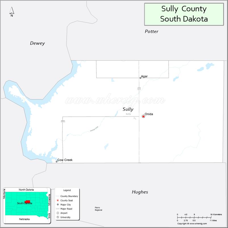
About Sully County Map, South Dakota: The map showing the county boundary, county seat, major cities, highways, water bodies and neighbouring counties.
More South Dakota Maps & Info
About Sully County, South Dakota
Sully County is a county located in the U.S. state of South Dakota. It's county seat is Onida. As per 2020 census, the population of Sully County is 1476 people and population density is square miles. According to the United States Census Bureau, the county has a total area of 1,007 sq mi (2,608 km2). Sully County was established on 1873.
Sully County Facts
| Continent | North America |
| Country | United States |
| State | South Dakota |
| County Seat | Onida |
| Largest City/Town | Onida |
| Established | 1873 |
| Total Area | 1,070 sq mi (2,771 sq km) |
| Land Area | 1,007 sq mi (2,608 sq km) |
| Water Area | 63 sq mi (163 sq km) |
| Population | 1,446 (Census 2020) |
| Population Density | 1.4 people per sq mi |
| Time Zone | Central Time Zone (CT) |
| Major Highways | US 83, SD 1804, SD 34 |
| Major Rivers | Missouri River |
| Neighboring Counties | Potter County, Walworth County, Hughes County, Stanley County, Hyde County |
| Famous For | Missouri River recreation, fishing and hunting, ranching, prairie landscapes |
| Top Attractions | Lake Oahe recreation, Onida attractions, fishing and hunting areas, prairie scenic drives |
| Official Website | Official Website |
About Sully County, South Dakota
Sully County is located in central South Dakota in the United States and was established in 1873. The county seat and largest town is Onida. The county is known for Missouri River recreation, ranching heritage, fishing and hunting opportunities, and scenic prairie landscapes.
Cities and Towns in Sully County, South Dakota
| City/Town | Population (Census 2020) | Latitude & Longitude |
|---|---|---|
| Onida (county seat) | 658 | 44.7083°N, 100.0585°W |
| Harrold | 84 | 44.5258°N, 99.7387°W |
| Agar nearby | 76 | 44.8397°N, 100.0709°W |
| Gettysburg nearby | 1,104 | 45.0111°N, 99.9554°W |
| Pierre nearby | 14,091 | 44.3683°N, 100.3510°W |
| Selby nearby | 642 | 45.5050°N, 100.0323°W |
Golf Courses in Sully County, South Dakota
| Golf Course | Location | Latitude & Longitude |
|---|---|---|
| Onida Golf Course | Onida | 44.7142°N, 100.0649°W |
| Gettysburg Country Club nearby | Gettysburg | 45.0158°N, 99.9647°W |
| Hillsview Golf Course nearby | Pierre | 44.3784°N, 100.3389°W |
| Mobridge Country Club nearby | Mobridge | 45.5386°N, 100.4234°W |
Roads and Highways in Sully County, South Dakota
Major highways connect the county to central South Dakota communities and Missouri River recreation regions.
- US Highway 83 - major north-south highway through central South Dakota
- South Dakota Highway 1804 - scenic route following the Missouri River
- South Dakota Highway 34 - regional roadway serving prairie communities
What are Neighboring Counties of Sully County
- Potter County (north)
- Walworth County (northwest)
- Hughes County (south)
- Stanley County (southwest)
- Hyde County (east)
What are the Top Attractions in Sully County, South Dakota
The county offers a mix of Missouri River recreation, prairie landscapes, and outdoor adventure opportunities.
- Lake Oahe recreation - boating, fishing, camping, and water sports activities
- Onida attractions - local restaurants, shops, museums, and community events
- Fishing and hunting destinations - walleye fishing, pheasant hunting, and wildlife recreation
- Prairie scenic drives - rolling ranchland and Missouri River Valley landscapes
- Onida Golf Course - golf and recreation facility
- Birdwatching and wildlife habitats - prairie wetlands and migratory birds
- Camping and RV parks nearby - outdoor recreation and travel destinations
- Photography and sunset viewing along the Missouri River - scenic outdoor experiences
- Historic ranching communities - cowboy culture and western heritage
- Regional rodeos and county fairs - celebrating ranching and agriculture traditions
- Boating marinas and recreation access points - Missouri River adventure opportunities
- Winter ice fishing and snowmobiling activities - seasonal outdoor recreation
- Historic churches and prairie landmarks - reflecting pioneer settlement history
- Nearby Pierre attractions - museums, shopping, and South Dakota State Capitol tours
What is the Distance from Sully County to Nearby Cities
The following distances are measured by road (driving).
- Onida to Pierre (Hughes County), South Dakota - 42 mi (68 km)
- Onida to Gettysburg (Potter County), South Dakota - 32 mi (51 km)
- Onida to Mobridge (Walworth County), South Dakota - 101 mi (163 km)
- Onida to Aberdeen (Brown County), South Dakota - 140 mi (225 km)
- Onida to Rapid City (Pennington County), South Dakota - 218 mi (351 km)
- Onida to Sioux Falls (Minnehaha County), South Dakota - 247 mi (398 km)
- Onida to Bismarck (Burleigh County), North Dakota - 201 mi (323 km)
- Onida to Fargo (Cass County), North Dakota - 327 mi (526 km)
- Onida to Omaha (Douglas County), Nebraska - 412 mi (663 km)
- Onida to Billings (Yellowstone County), Montana - 438 mi (705 km)
- Onida to Minneapolis (Hennepin County), Minnesota - 455 mi (732 km)
- Onida to Denver (Denver County), Colorado - 581 mi (935 km)
FAQs about Sully County
Sully County is located in central South Dakota along the Missouri River and Lake Oahe region.
Sully County had a population of 1,446 according to the 2020 United States Census.
Sully County is known for Missouri River recreation, fishing and hunting, ranching, and scenic prairie landscapes.
The major highways include US Highway 83, South Dakota Highway 1804, and South Dakota Highway 34.
Popular attractions include Lake Oahe recreation areas, Missouri River fishing destinations, and scenic prairie drives.
References
- QuickFacts - U.S. Census Bureau
- United States Census Bureau
- United States Geological Survey (USGS)
- National Geodetic Survey
- Official Website
- Aurora County Map
- Beadle County Map
- Bennett County Map
- Bon Homme County Map
- Brookings County Map
- Brown County Map
- Brule County Map
- Buffalo County Map
- Butte County Map
- Campbell County Map
- Charles Mix County Map
- Clark County Map
- Clay County Map
- Codington County Map
- Corson County Map
- Custer County Map
- Davison County Map
- Day County Map
- Deuel County Map
- Dewey County Map
- Douglas County Map
- Edmunds County Map
- Fall River County Map
- Faulk County Map
- Grant County Map
- Gregory County Map
- Haakon County Map
- Hamlin County Map
- Hand County Map
- Hanson County Map
- Harding County Map
- Hughes County Map
- Hutchinson County Map
- Hyde County Map
- Jackson County Map
- Jerauld County Map
- Jones County Map
- Kingsbury County Map
- Lake County Map
- Lawrence County Map
- Lincoln County Map
- Lyman County Map
- McCook County Map
- McPherson County Map
- Marshall County Map
- Meade County Map
- Mellette County Map
- Miner County Map
- Minnehaha County Map
- Moody County Map
- Oglala Lakota County Map
- Pennington County Map
- Perkins County Map
- Potter County Map
- Roberts County Map
- Sanborn County Map
- Spink County Map
- Stanley County Map
- Sully County Map
- Todd County Map
- Tripp County Map
- Turner County Map
- Union County Map
- Walworth County Map
- Yankton County Map
- Ziebach County Map
- Alabama Counties
- Alaska boroughs
- Arizona Counties
- Arkansas Counties
- California County Map
- Colorado Counties
- Connecticut Counties
- Delaware Counties
- Florida County Map
- Georgia County Map
- Hawaii Counties
- Idaho Counties
- Illinois Counties
- Indiana Counties
- Iowa Counties
- Kansas Counties
- Kentucky Counties
- Louisiana Counties
- Maine Counties
- Maryland Counties
- Massachusetts Counties
- Michigan County Map
- Minnesota Counties
- Mississippi Counties
- Missouri Counties
- Montana Counties
- Nebraska Counties
- Nevada Counties
- New York Counties
- New Hampshire Counties
- New Jersey Counties
- New Mexico Counties
- North Carolina Counties
- North Dakota Counties
- Ohio County Map
- Oklahoma Counties
- Oregon Counties
- Pennsylvania Counties
- Rhode Island Counties
- South Carolina Counties
- South Dakota Counties
- Map of Tennessee
- Texas County Map
- Utah Counties
- Vermont Counties
- Virginia Counties
- Washington Counties
- West Virginia Counties
- Wisconsin Counties
- Wyoming Counties