Written and Fact-checked by Whereig Editors, Reviewed by Mukesh Kumar| Last Updated On: May 11, 2026
Map of Meade County - Meade County is a county located in the U.S. state of South Dakota. Meade County Map showing cities, highways, important places and water bodies. Get Where is Meade County located in the map, major cities in Meade county, population, areas, and places of interest.
Map of Meade County, South Dakota
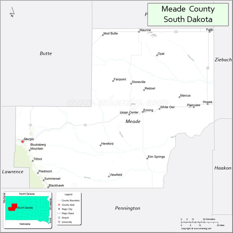
About Meade County Map, South Dakota: The map showing the county boundary, county seat, major cities, highways, water bodies and neighbouring counties.
More South Dakota Maps & Info
About Meade County, South Dakota
Meade County is a county located in the U.S. state of South Dakota. It's county seat is Sturgis. As per 2020 census, the population of Meade County is 30173 people and population density is square miles. According to the United States Census Bureau, the county has a total area of 3,471 sq mi (8,990 km2). Meade County was established on 1889.
Meade County Facts
| Continent | North America |
| Country | United States |
| State | South Dakota |
| County Seat | Sturgis |
| Largest City/Town | Sturgis |
| Established | 1889 |
| Total Area | 3,482 sq mi (9,018 sq km) |
| Land Area | 3,471 sq mi (8,990 sq km) |
| Water Area | 11 sq mi (28 sq km) |
| Population | 29,852 (Census 2020) |
| Population Density | 8.6 people per sq mi |
| Time Zone | Mountain Time Zone (MT) |
| Major Highways | Interstate 90, US 14A, US 85 |
| Major Rivers | Belle Fourche River, Cheyenne River |
| Neighboring Counties | Butte County, Lawrence County, Pennington County, Haakon County, Ziebach County, Perkins County |
| Famous For | Sturgis Motorcycle Rally, Black Hills recreation, ranching, military history |
| Top Attractions | Sturgis Motorcycle Museum, Bear Butte State Park, Fort Meade Museum, Black Hills recreation areas |
| Official Website | Official Website |
About Meade County, South Dakota
Meade County is located in western South Dakota in the United States and was established in 1889. The county seat and largest city is Sturgis. Meade County is the largest county in South Dakota by area and is famous for the annual Sturgis Motorcycle Rally, Black Hills scenery, ranching heritage, and outdoor recreation opportunities.
Cities and Towns in Meade County, South Dakota
| City/Town | Population (Census 2020) | Latitude & Longitude |
|---|---|---|
| Sturgis (county seat) | 7,020 | 44.4097°N, 103.5091°W |
| Piedmont | 971 | 44.2311°N, 103.3896°W |
| Summerset | 2,814 | 44.1972°N, 103.2835°W |
| Union Center | 11 | 44.6531°N, 102.5654°W |
| Black Hawk nearby | 2,892 | 44.1517°N, 103.3074°W |
| Nisland nearby | 204 | 44.6630°N, 103.5427°W |
Golf Courses in Meade County, South Dakota
| Golf Course | Location | Latitude & Longitude |
|---|---|---|
| Sturgis Country Club | Sturgis | 44.4118°N, 103.5204°W |
| Elkhorn Ridge Golf Club nearby | Spearfish | 44.5274°N, 103.8968°W |
| Hart Ranch Golf Club nearby | Rapid City | 43.9778°N, 103.3112°W |
| Belle Fourche Country Club nearby | Belle Fourche | 44.6713°N, 103.8528°W |
Roads and Highways in Meade County, South Dakota
Major highways connect the county to the Black Hills region, western South Dakota communities, and Interstate travel corridors.
- Interstate 90 - major east-west interstate highway through western South Dakota
- US Highway 14A - scenic route connecting Black Hills communities
- US Highway 85 - important north-south highway linking South Dakota and Wyoming
What are Neighboring Counties of Meade County
- Butte County (north)
- Lawrence County (west)
- Pennington County (south)
- Haakon County (east)
- Ziebach County (northeast)
- Perkins County (northwest)
What are the Top Attractions in Meade County, South Dakota
The county offers a mix of Black Hills scenery, motorcycle culture, western history, and outdoor recreation.
- Sturgis Motorcycle Museum - exhibits celebrating motorcycle history and the famous rally
- Bear Butte State Park - hiking, wildlife viewing, and sacred cultural landmark
- Fort Meade Museum - military history and frontier heritage attractions
- Black Hills recreation areas - hiking, camping, mountain biking, and scenic drives
- Sturgis Motorcycle Rally - internationally famous annual motorcycle event
- Sturgis attractions - restaurants, shopping, entertainment, and local museums
- Cheyenne River and Belle Fourche River recreation - fishing and outdoor activities
- Camping and RV parks throughout the county - popular travel and recreation destinations
- Photography and wildlife viewing - forests, grasslands, and mountain scenery
- Off-road trails and ATV recreation - outdoor adventure opportunities
- Historic ranching communities - western South Dakota heritage and culture
- Golf and recreation facilities - local and regional golf destinations
- Scenic motorcycle routes through the Black Hills - popular travel experiences
- Winter snowmobiling and outdoor recreation - seasonal Black Hills adventures
What is the Distance from Meade County to Nearby Cities
The following distances are measured by road (driving).
- Sturgis to Rapid City (Pennington County), South Dakota - 31 mi (50 km)
- Sturgis to Spearfish (Lawrence County), South Dakota - 19 mi (31 km)
- Sturgis to Belle Fourche (Butte County), South Dakota - 25 mi (40 km)
- Sturgis to Deadwood (Lawrence County), South Dakota - 14 mi (23 km)
- Sturgis to Gillette (Campbell County), Wyoming - 118 mi (190 km)
- Sturgis to Casper (Natrona County), Wyoming - 201 mi (323 km)
- Sturgis to Pierre (Hughes County), South Dakota - 180 mi (290 km)
- Sturgis to Billings (Yellowstone County), Montana - 282 mi (454 km)
- Sturgis to Sioux Falls (Minnehaha County), South Dakota - 347 mi (558 km)
- Sturgis to Denver (Denver County), Colorado - 392 mi (631 km)
- Sturgis to Bismarck (Burleigh County), North Dakota - 291 mi (468 km)
- Sturgis to Omaha (Douglas County), Nebraska - 519 mi (835 km)
FAQs about Meade County
Meade County is located in western South Dakota in the Black Hills region.
Meade County had a population of 29,852 according to the 2020 United States Census.
Meade County is known for the Sturgis Motorcycle Rally, Black Hills recreation, ranching, and western heritage.
The major highways include Interstate 90, US Highway 14A, and US Highway 85.
Yes, Meade County has golf facilities including Sturgis Country Club and nearby Black Hills golf courses.
References
- QuickFacts - U.S. Census Bureau
- United States Census Bureau
- United States Geological Survey (USGS)
- National Geodetic Survey
- Official Website
- Aurora County Map
- Beadle County Map
- Bennett County Map
- Bon Homme County Map
- Brookings County Map
- Brown County Map
- Brule County Map
- Buffalo County Map
- Butte County Map
- Campbell County Map
- Charles Mix County Map
- Clark County Map
- Clay County Map
- Codington County Map
- Corson County Map
- Custer County Map
- Davison County Map
- Day County Map
- Deuel County Map
- Dewey County Map
- Douglas County Map
- Edmunds County Map
- Fall River County Map
- Faulk County Map
- Grant County Map
- Gregory County Map
- Haakon County Map
- Hamlin County Map
- Hand County Map
- Hanson County Map
- Harding County Map
- Hughes County Map
- Hutchinson County Map
- Hyde County Map
- Jackson County Map
- Jerauld County Map
- Jones County Map
- Kingsbury County Map
- Lake County Map
- Lawrence County Map
- Lincoln County Map
- Lyman County Map
- McCook County Map
- McPherson County Map
- Marshall County Map
- Meade County Map
- Mellette County Map
- Miner County Map
- Minnehaha County Map
- Moody County Map
- Oglala Lakota County Map
- Pennington County Map
- Perkins County Map
- Potter County Map
- Roberts County Map
- Sanborn County Map
- Spink County Map
- Stanley County Map
- Sully County Map
- Todd County Map
- Tripp County Map
- Turner County Map
- Union County Map
- Walworth County Map
- Yankton County Map
- Ziebach County Map
- Alabama Counties
- Alaska boroughs
- Arizona Counties
- Arkansas Counties
- California County Map
- Colorado Counties
- Connecticut Counties
- Delaware Counties
- Florida County Map
- Georgia County Map
- Hawaii Counties
- Idaho Counties
- Illinois Counties
- Indiana Counties
- Iowa Counties
- Kansas Counties
- Kentucky Counties
- Louisiana Counties
- Maine Counties
- Maryland Counties
- Massachusetts Counties
- Michigan County Map
- Minnesota Counties
- Mississippi Counties
- Missouri Counties
- Montana Counties
- Nebraska Counties
- Nevada Counties
- New York Counties
- New Hampshire Counties
- New Jersey Counties
- New Mexico Counties
- North Carolina Counties
- North Dakota Counties
- Ohio County Map
- Oklahoma Counties
- Oregon Counties
- Pennsylvania Counties
- Rhode Island Counties
- South Carolina Counties
- South Dakota Counties
- Map of Tennessee
- Texas County Map
- Utah Counties
- Vermont Counties
- Virginia Counties
- Washington Counties
- West Virginia Counties
- Wisconsin Counties
- Wyoming Counties