Written and Fact-checked by Whereig Editors, Reviewed by Mukesh Kumar| Last Updated On: May 11, 2026
Map of Codington County - Codington County is a county located in the U.S. state of South Dakota. Codington County Map showing cities, highways, important places and water bodies. Get Where is Codington County located in the map, major cities in Codington county, population, areas, and places of interest.
Map of Codington County, South Dakota
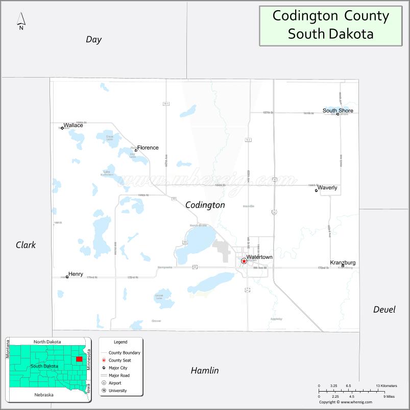
About Codington County Map, South Dakota: The map showing the county boundary, county seat, major cities, highways, water bodies and neighbouring counties.
More South Dakota Maps & Info
About Codington County, South Dakota
Codington County is a county located in the U.S. state of South Dakota. It's county seat is Watertown. As per 2020 census, the population of Codington County is 28427 people and population density is square miles. According to the United States Census Bureau, the county has a total area of 688 sq mi (1,782 km2). Codington County was established on 1877.
Codington County Facts
| Continent | North America |
| Country | United States |
| State | South Dakota |
| County Seat | Watertown |
| Largest City/Town | Watertown |
| Established | 1877 |
| Total Area | 717 sq mi (1,857 sq km) |
| Land Area | 688 sq mi (1,782 sq km) |
| Water Area | 29 sq mi (75 sq km) |
| Population | 28,325 (Census 2020) |
| Population Density | 41.2 people per sq mi |
| Time Zone | Central Time Zone (CT) |
| Major Highways | Interstate 29, US 81, US 212, SD 20 |
| Major Rivers | Big Sioux River nearby |
| Neighboring Counties | Deuel County, Grant County, Hamlin County, Day County, Clark County |
| Famous For | Watertown, Lake Kampeska, manufacturing, outdoor recreation |
| Top Attractions | Lake Kampeska, Bramble Park Zoo, Redlin Art Center, Watertown Family Aquatic Center |
| Official Website | Official Website |
About Codington County, South Dakota
Codington County is located in northeastern South Dakota in the United States and was established in 1877. The county seat and largest city is Watertown. The county is known for lakes and outdoor recreation, manufacturing industries, tourism, and serving as an economic center for northeastern South Dakota.
Cities and Towns in Codington County, South Dakota
| City/Town | Population (Census 2020) | Latitude & Longitude |
|---|---|---|
| Watertown (county seat) | 22,655 | 44.8994°N, 97.1151°W |
| Henry | 267 | 44.8780°N, 97.4712°W |
| Kranzburg | 163 | 44.8936°N, 96.9598°W |
| South Shore | 177 | 45.1036°N, 96.9206°W |
| Florence nearby | 372 | 44.9519°N, 97.3237°W |
| Waverly nearby | 1,357 | 44.9819°N, 97.2140°W |
Golf Courses in Codington County, South Dakota
| Golf Course | Location | Latitude & Longitude |
|---|---|---|
| Watertown Country Club | Watertown | 44.8875°N, 97.1156°W |
| Cattail Crossing Golf Course | Watertown | 44.8899°N, 97.1457°W |
| Prairie Winds Golf Club nearby | Milbank | 45.2185°N, 96.6334°W |
| Lake Region Golf Club nearby | Arlington | 44.3642°N, 97.1315°W |
Roads and Highways in Codington County, South Dakota
Major highways connect the county to Minnesota, North Dakota, and eastern South Dakota communities.
- Interstate 29 - major north-south interstate through eastern South Dakota
- US Highway 81 - regional route linking Watertown with Nebraska and North Dakota
- US Highway 212 - east-west route serving northeastern South Dakota
- South Dakota Highway 20 - highway connecting local communities and recreation areas
What are Neighboring Counties of Codington County
- Grant County (north)
- Deuel County (east)
- Hamlin County (south)
- Clark County (west)
- Day County (northwest)
What are the Top Attractions in Codington County, South Dakota
The county offers a mix of lake recreation, cultural attractions, and family entertainment.
- Lake Kampeska - popular boating, fishing, swimming, and lakeside recreation destination
- Bramble Park Zoo - family-friendly zoo featuring native and exotic animals
- Redlin Art Center - museum showcasing the artwork of Terry Redlin
- Watertown Family Aquatic Center - water slides, pools, and recreation facilities
- Mellette House Museum - historic Victorian-era home and museum
- Cattail Crossing Golf Course - scenic public golf course in Watertown
- Downtown Watertown - restaurants, shopping, and entertainment venues
- Fishing and hunting areas - walleye fishing and pheasant hunting destinations
- Lake Pelican and nearby lakes - camping and outdoor recreation opportunities
- Terry Redlin Environmental Center - wildlife viewing and educational exhibits
- Codington County Heritage Museum - local history and pioneer exhibits
- Prairie Wetlands Learning Center nearby - birdwatching and environmental education
- Seasonal fairs and festivals - celebrating local agriculture and culture
- Snowmobiling and winter recreation trails - outdoor activities during winter months
What is the Distance from Codington County to Nearby Cities
The following distances are measured by road (driving).
- Watertown to Brookings (Brookings County), South Dakota - 53 mi (85 km)
- Watertown to Aberdeen (Brown County), South Dakota - 105 mi (169 km)
- Watertown to Sioux Falls (Minnehaha County), South Dakota - 102 mi (164 km)
- Watertown to Fargo (Cass County), North Dakota - 164 mi (264 km)
- Watertown to Minneapolis (Hennepin County), Minnesota - 209 mi (336 km)
- Watertown to Pierre (Hughes County), South Dakota - 221 mi (356 km)
- Watertown to Omaha (Douglas County), Nebraska - 257 mi (414 km)
- Watertown to Rapid City (Pennington County), South Dakota - 426 mi (686 km)
- Watertown to Sioux City (Woodbury County), Iowa - 172 mi (277 km)
- Watertown to Bismarck (Burleigh County), North Dakota - 327 mi (526 km)
- Watertown to Kansas City (Jackson County), Missouri - 484 mi (779 km)
- Watertown to Denver (Denver County), Colorado - 647 mi (1,041 km)
FAQs about Codington County
Codington County is located in northeastern South Dakota near the Minnesota border.
Codington County had a population of 28,325 according to the 2020 United States Census.
Codington County is known for Watertown, Lake Kampeska, outdoor recreation, and manufacturing industries.
The major highways include Interstate 29, US Highway 81, US Highway 212, and South Dakota Highway 20.
Yes, Codington County has golf facilities including Watertown Country Club and Cattail Crossing Golf Course.
References
- QuickFacts - U.S. Census Bureau
- United States Census Bureau
- United States Geological Survey (USGS)
- National Geodetic Survey
- Official Website
- Aurora County Map
- Beadle County Map
- Bennett County Map
- Bon Homme County Map
- Brookings County Map
- Brown County Map
- Brule County Map
- Buffalo County Map
- Butte County Map
- Campbell County Map
- Charles Mix County Map
- Clark County Map
- Clay County Map
- Codington County Map
- Corson County Map
- Custer County Map
- Davison County Map
- Day County Map
- Deuel County Map
- Dewey County Map
- Douglas County Map
- Edmunds County Map
- Fall River County Map
- Faulk County Map
- Grant County Map
- Gregory County Map
- Haakon County Map
- Hamlin County Map
- Hand County Map
- Hanson County Map
- Harding County Map
- Hughes County Map
- Hutchinson County Map
- Hyde County Map
- Jackson County Map
- Jerauld County Map
- Jones County Map
- Kingsbury County Map
- Lake County Map
- Lawrence County Map
- Lincoln County Map
- Lyman County Map
- McCook County Map
- McPherson County Map
- Marshall County Map
- Meade County Map
- Mellette County Map
- Miner County Map
- Minnehaha County Map
- Moody County Map
- Oglala Lakota County Map
- Pennington County Map
- Perkins County Map
- Potter County Map
- Roberts County Map
- Sanborn County Map
- Spink County Map
- Stanley County Map
- Sully County Map
- Todd County Map
- Tripp County Map
- Turner County Map
- Union County Map
- Walworth County Map
- Yankton County Map
- Ziebach County Map
- Alabama Counties
- Alaska boroughs
- Arizona Counties
- Arkansas Counties
- California County Map
- Colorado Counties
- Connecticut Counties
- Delaware Counties
- Florida County Map
- Georgia County Map
- Hawaii Counties
- Idaho Counties
- Illinois Counties
- Indiana Counties
- Iowa Counties
- Kansas Counties
- Kentucky Counties
- Louisiana Counties
- Maine Counties
- Maryland Counties
- Massachusetts Counties
- Michigan County Map
- Minnesota Counties
- Mississippi Counties
- Missouri Counties
- Montana Counties
- Nebraska Counties
- Nevada Counties
- New York Counties
- New Hampshire Counties
- New Jersey Counties
- New Mexico Counties
- North Carolina Counties
- North Dakota Counties
- Ohio County Map
- Oklahoma Counties
- Oregon Counties
- Pennsylvania Counties
- Rhode Island Counties
- South Carolina Counties
- South Dakota Counties
- Map of Tennessee
- Texas County Map
- Utah Counties
- Vermont Counties
- Virginia Counties
- Washington Counties
- West Virginia Counties
- Wisconsin Counties
- Wyoming Counties