Written and Fact-checked by Whereig Editors, Reviewed by Mukesh Kumar| Last Updated On: May 11, 2026
Map of Yankton County - Yankton County is a county located in the U.S. state of South Dakota. Yankton County Map showing cities, highways, important places and water bodies. Get Where is Yankton County located in the map, major cities in Yankton county, population, areas, and places of interest.
Map of Yankton County, South Dakota
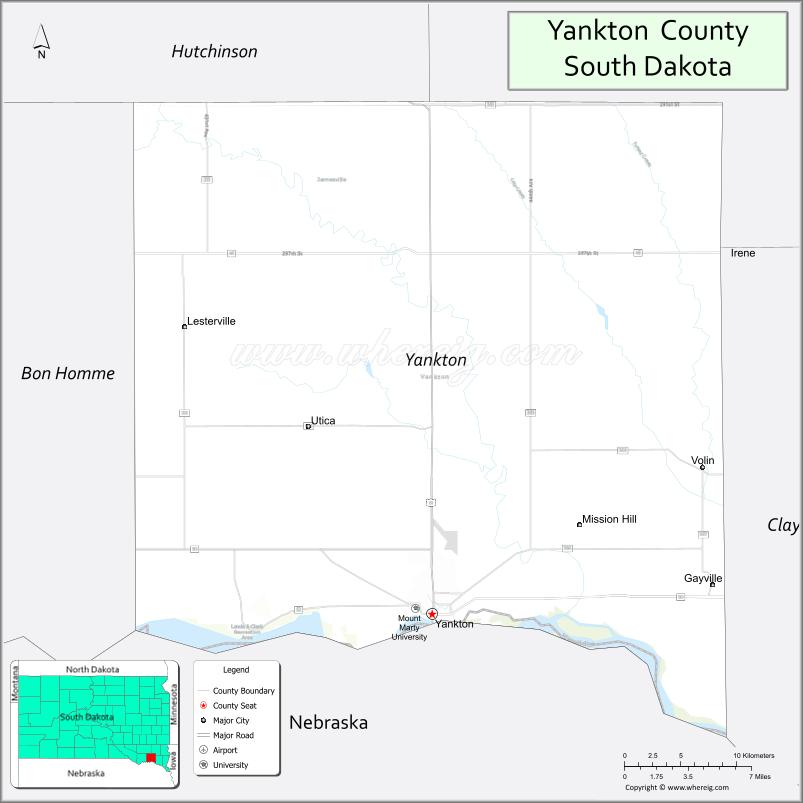
About Yankton County Map, South Dakota: The map showing the county boundary, county seat, major cities, highways, water bodies and neighbouring counties.
More South Dakota Maps & Info
About Yankton County, South Dakota
Yankton County is a county located in the U.S. state of South Dakota. It's county seat is Yankton. As per 2020 census, the population of Yankton County is 23297 people and population density is square miles. According to the United States Census Bureau, the county has a total area of 522 sq mi (1,352 km2). Yankton County was established on 1862.
Yankton County Facts
| Continent | North America |
| Country | United States |
| State | South Dakota |
| County Seat | Yankton |
| Largest City/Town | Yankton |
| Established | 1862 |
| Total Area | 532 sq mi (1,378 sq km) |
| Land Area | 521 sq mi (1,349 sq km) |
| Water Area | 11 sq mi (29 sq km) |
| Population | 23,310 (Census 2020) |
| Population Density | 44.7 people per sq mi |
| Time Zone | Central Time Zone (CT) |
| Major Highways | US 81, US 50, SD 52 |
| Major Rivers | Missouri River |
| Neighboring Counties | Bon Homme County, Clay County, Hutchinson County, Cedar County (NE), Knox County (NE), Union County |
| Famous For | Lewis and Clark Lake, Yankton history, Missouri River recreation, Gavins Point Dam |
| Top Attractions | Lewis and Clark Recreation Area, Gavins Point Dam, historic Yankton, Missouri National Recreational River |
| Official Website | Official Website |
About Yankton County, South Dakota
Yankton County is located in southeastern South Dakota in the United States and was established in 1862. The county seat and largest city is Yankton, which served as the first capital of Dakota Territory. The county is known for Missouri River recreation, historic attractions, Lewis and Clark Lake, and outdoor adventure opportunities.
Cities and Towns in Yankton County, South Dakota
| City/Town | Population (Census 2020) | Latitude & Longitude |
|---|---|---|
| Yankton (county seat) | 15,411 | 42.8711°N, 97.3973°W |
| Volin | 161 | 42.9564°N, 97.1806°W |
| Lesterville | 85 | 43.0381°N, 97.5815°W |
| Mission Hill | 177 | 42.9633°N, 97.2995°W |
| Gayville | 418 | 42.8894°N, 97.1731°W |
| Utica | 65 | 43.0097°N, 97.5034°W |
Golf Courses in Yankton County, South Dakota
| Golf Course | Location | Latitude & Longitude |
|---|---|---|
| Fox Run Golf Course | Yankton | 42.8875°N, 97.4028°W |
| Hillcrest Golf & Country Club | Yankton | 42.8847°N, 97.3890°W |
| Lewis and Clark Golf Course nearby | Crofton, Nebraska | 42.7386°N, 97.4974°W |
| Turkey Ridge Creek Golf Course nearby | Centerville | 43.1097°N, 96.9636°W |
Roads and Highways in Yankton County, South Dakota
Major highways connect the county to southeastern South Dakota, Nebraska, and regional Missouri River destinations.
- US Highway 81 - major north-south highway connecting South Dakota and Nebraska
- US Highway 50 - important east-west route through the Missouri River region
- South Dakota Highway 52 - regional roadway serving local communities
What are Neighboring Counties of Yankton County
- Hutchinson County (north)
- Clay County (east)
- Union County (southeast)
- Bon Homme County (west)
- Cedar County, Nebraska (south)
- Knox County, Nebraska (southwest)
What are the Top Attractions in Yankton County, South Dakota
The county offers a mix of Missouri River recreation, historical attractions, and outdoor adventure destinations.
- Lewis and Clark Recreation Area - camping, boating, beaches, and outdoor recreation
- Gavins Point Dam - Missouri River landmark and hydroelectric facility
- Historic downtown Yankton - shops, museums, restaurants, and cultural attractions
- Missouri National Recreational River - kayaking, fishing, wildlife viewing, and scenic river experiences
- Fox Run Golf Course - golf and recreation destination
- Lewis and Clark Lake recreation - boating, fishing, swimming, and camping opportunities
- Dakota Territorial Museum - regional history and pioneer exhibits
- Chief White Crane Recreation Area - camping and lakeside outdoor activities
- Birdwatching and wildlife habitats - river ecosystems and migratory birds
- Photography and sunset viewing along the Missouri River - scenic outdoor experiences
- Fishing and hunting destinations - walleye fishing and waterfowl recreation
- Regional festivals and community events - celebrating local culture and heritage
- Historic churches and territorial landmarks - reflecting Dakota Territory history
- Nearby Nebraska recreation areas - additional river and lake destinations
What is the Distance from Yankton County to Nearby Cities
The following distances are measured by road (driving).
- Yankton to Sioux City (Woodbury County), Iowa - 61 mi (98 km)
- Yankton to Sioux Falls (Minnehaha County), South Dakota - 83 mi (134 km)
- Yankton to Omaha (Douglas County), Nebraska - 162 mi (261 km)
- Yankton to Lincoln (Lancaster County), Nebraska - 182 mi (293 km)
- Yankton to Brookings (Brookings County), South Dakota - 136 mi (219 km)
- Yankton to Pierre (Hughes County), South Dakota - 227 mi (365 km)
- Yankton to Des Moines (Polk County), Iowa - 252 mi (406 km)
- Yankton to Fargo (Cass County), North Dakota - 325 mi (523 km)
- Yankton to Minneapolis (Hennepin County), Minnesota - 308 mi (496 km)
- Yankton to Rapid City (Pennington County), South Dakota - 409 mi (658 km)
- Yankton to Denver (Denver County), Colorado - 647 mi (1,041 km)
- Yankton to Kansas City (Jackson County), Missouri - 322 mi (518 km)
FAQs about Yankton County
Yankton County is located in southeastern South Dakota along the Missouri River and the Nebraska border.
Yankton County had a population of 23,310 according to the 2020 United States Census.
Yankton County is known for Lewis and Clark Lake, Missouri River recreation, historic Yankton, and Gavins Point Dam.
The major highways include US Highway 81, US Highway 50, and South Dakota Highway 52.
Popular attractions include Lewis and Clark Recreation Area, Gavins Point Dam, Missouri National Recreational River, and historic Yankton.
References
- QuickFacts - U.S. Census Bureau
- United States Census Bureau
- United States Geological Survey (USGS)
- National Geodetic Survey
- Official Website
- Aurora County Map
- Beadle County Map
- Bennett County Map
- Bon Homme County Map
- Brookings County Map
- Brown County Map
- Brule County Map
- Buffalo County Map
- Butte County Map
- Campbell County Map
- Charles Mix County Map
- Clark County Map
- Clay County Map
- Codington County Map
- Corson County Map
- Custer County Map
- Davison County Map
- Day County Map
- Deuel County Map
- Dewey County Map
- Douglas County Map
- Edmunds County Map
- Fall River County Map
- Faulk County Map
- Grant County Map
- Gregory County Map
- Haakon County Map
- Hamlin County Map
- Hand County Map
- Hanson County Map
- Harding County Map
- Hughes County Map
- Hutchinson County Map
- Hyde County Map
- Jackson County Map
- Jerauld County Map
- Jones County Map
- Kingsbury County Map
- Lake County Map
- Lawrence County Map
- Lincoln County Map
- Lyman County Map
- McCook County Map
- McPherson County Map
- Marshall County Map
- Meade County Map
- Mellette County Map
- Miner County Map
- Minnehaha County Map
- Moody County Map
- Oglala Lakota County Map
- Pennington County Map
- Perkins County Map
- Potter County Map
- Roberts County Map
- Sanborn County Map
- Spink County Map
- Stanley County Map
- Sully County Map
- Todd County Map
- Tripp County Map
- Turner County Map
- Union County Map
- Walworth County Map
- Yankton County Map
- Ziebach County Map
- Alabama Counties
- Alaska boroughs
- Arizona Counties
- Arkansas Counties
- California County Map
- Colorado Counties
- Connecticut Counties
- Delaware Counties
- Florida County Map
- Georgia County Map
- Hawaii Counties
- Idaho Counties
- Illinois Counties
- Indiana Counties
- Iowa Counties
- Kansas Counties
- Kentucky Counties
- Louisiana Counties
- Maine Counties
- Maryland Counties
- Massachusetts Counties
- Michigan County Map
- Minnesota Counties
- Mississippi Counties
- Missouri Counties
- Montana Counties
- Nebraska Counties
- Nevada Counties
- New York Counties
- New Hampshire Counties
- New Jersey Counties
- New Mexico Counties
- North Carolina Counties
- North Dakota Counties
- Ohio County Map
- Oklahoma Counties
- Oregon Counties
- Pennsylvania Counties
- Rhode Island Counties
- South Carolina Counties
- South Dakota Counties
- Map of Tennessee
- Texas County Map
- Utah Counties
- Vermont Counties
- Virginia Counties
- Washington Counties
- West Virginia Counties
- Wisconsin Counties
- Wyoming Counties