Written and Fact-checked by Whereig Editors, Reviewed by Mukesh Kumar| Last Updated On: May 11, 2026
Map of Moody County - Moody County is a county located in the U.S. state of South Dakota. Moody County Map showing cities, highways, important places and water bodies. Get Where is Moody County located in the map, major cities in Moody county, population, areas, and places of interest.
Map of Moody County, South Dakota
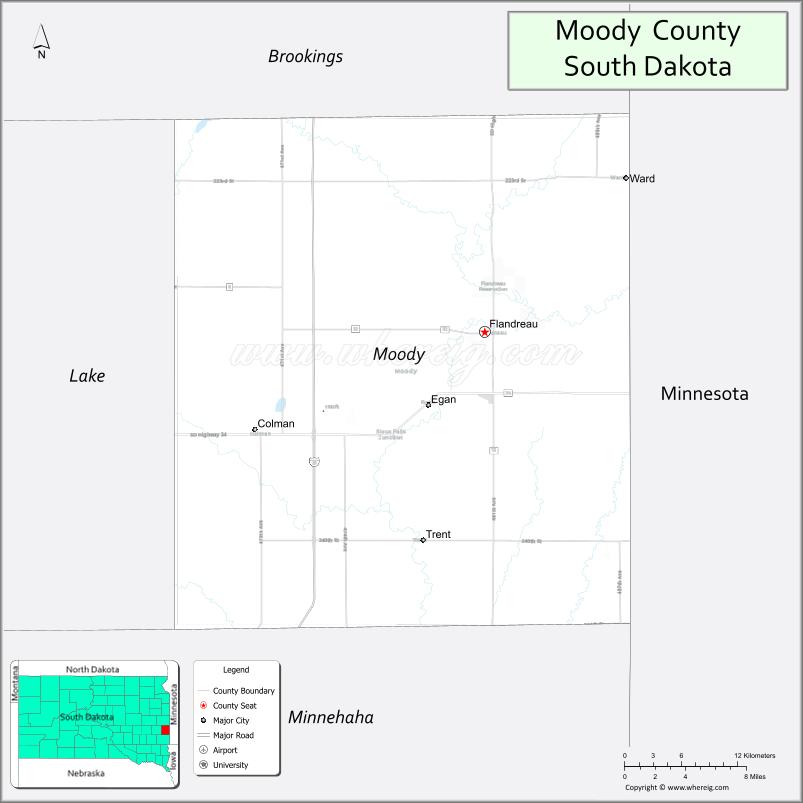
About Moody County Map, South Dakota: The map showing the county boundary, county seat, major cities, highways, water bodies and neighbouring counties.
More South Dakota Maps & Info
About Moody County, South Dakota
Moody County is a county located in the U.S. state of South Dakota. It's county seat is Flandreau. As per 2020 census, the population of Moody County is 6315 people and population density is square miles. According to the United States Census Bureau, the county has a total area of 520 sq mi (1,347 km2). Moody County was established on 1873.
Moody County Facts
| Continent | North America |
| Country | United States |
| State | South Dakota |
| County Seat | Flandreau |
| Largest City/Town | Flandreau |
| Established | 1873 |
| Total Area | 521 sq mi (1,349 sq km) |
| Land Area | 519 sq mi (1,344 sq km) |
| Water Area | 2 sq mi (5 sq km) |
| Population | 6,336 (Census 2020) |
| Population Density | 12.2 people per sq mi |
| Time Zone | Central Time Zone (CT) |
| Major Highways | Interstate 29, SD 32, SD 34 |
| Major Rivers | Big Sioux River |
| Neighboring Counties | Brookings County, Lake County, Minnehaha County, Pipestone County (MN) |
| Famous For | Flandreau Santee Sioux Tribe, agriculture, casino tourism, prairie recreation |
| Top Attractions | Royal River Casino, Flandreau attractions, Big Sioux River recreation, local parks |
| Official Website | Official Website |
About Moody County, South Dakota
Moody County is located in eastern South Dakota in the United States and was established in 1873. The county seat and largest city is Flandreau. The county is known for agriculture, the Flandreau Santee Sioux Tribe, casino tourism, and scenic prairie landscapes along the Big Sioux River.
Cities and Towns in Moody County, South Dakota
| City/Town | Population (Census 2020) | Latitude & Longitude |
|---|---|---|
| Flandreau (county seat) | 2,372 | 44.0497°N, 96.5981°W |
| Colman | 600 | 43.9800°N, 96.8106°W |
| Egan | 278 | 43.9775°N, 96.6498°W |
| Ward | 31 | 44.0511°N, 96.5570°W |
| Trent nearby | 232 | 43.9047°N, 96.6573°W |
| Dell Rapids nearby | 3,996 | 43.8247°N, 96.7120°W |
Golf Courses in Moody County, South Dakota
| Golf Course | Location | Latitude & Longitude |
|---|---|---|
| River Ridge Golf Course | Flandreau | 44.0521°N, 96.6052°W |
| Dell Rapids Golf Course nearby | Dell Rapids | 43.8242°N, 96.7078°W |
| Brookings Country Club nearby | Brookings | 44.3006°N, 96.7889°W |
| Hidden Valley Golf Club nearby | Brandon | 43.6025°N, 96.5822°W |
Roads and Highways in Moody County, South Dakota
Major highways connect the county to eastern South Dakota communities, Minnesota, and Interstate travel routes.
- Interstate 29 - major north-south interstate highway through eastern South Dakota
- South Dakota Highway 32 - east-west route connecting local communities
- South Dakota Highway 34 - regional roadway serving agricultural areas
What are Neighboring Counties of Moody County
- Brookings County (north)
- Lake County (west)
- Minnehaha County (south)
- Pipestone County, Minnesota (east)
What are the Top Attractions in Moody County, South Dakota
The county offers a mix of cultural attractions, prairie recreation, and riverfront outdoor activities.
- Royal River Casino - gaming, entertainment, dining, and hotel destination
- Flandreau attractions - local shops, restaurants, and community events
- Big Sioux River recreation - fishing, kayaking, and scenic outdoor activities
- Local parks and recreation areas - family-friendly outdoor spaces
- River Ridge Golf Course - golf and recreation facility
- Flandreau Santee Sioux cultural attractions - Native American heritage and traditions
- Prairie scenic drives - farmland and countryside landscapes
- Birdwatching and wildlife habitats - river and prairie ecosystems
- Camping and RV parks nearby - outdoor recreation destinations
- Photography and sunset viewing along the Big Sioux River - scenic experiences
- Regional fairs and festivals - celebrating agriculture and local culture
- Fishing ponds and recreation lakes nearby - outdoor relaxation opportunities
- Historic downtown Flandreau - architecture and local history attractions
- Nearby Sioux Falls and Brookings attractions - shopping, museums, and entertainment
What is the Distance from Moody County to Nearby Cities
The following distances are measured by road (driving).
- Flandreau to Brookings (Brookings County), South Dakota - 33 mi (53 km)
- Flandreau to Sioux Falls (Minnehaha County), South Dakota - 45 mi (72 km)
- Flandreau to Madison (Lake County), South Dakota - 34 mi (55 km)
- Flandreau to Watertown (Codington County), South Dakota - 72 mi (116 km)
- Flandreau to Sioux City (Woodbury County), Iowa - 111 mi (179 km)
- Flandreau to Fargo (Cass County), North Dakota - 200 mi (322 km)
- Flandreau to Minneapolis (Hennepin County), Minnesota - 218 mi (351 km)
- Flandreau to Omaha (Douglas County), Nebraska - 206 mi (332 km)
- Flandreau to Pierre (Hughes County), South Dakota - 234 mi (377 km)
- Flandreau to Rapid City (Pennington County), South Dakota - 401 mi (645 km)
- Flandreau to Kansas City (Jackson County), Missouri - 404 mi (650 km)
- Flandreau to Denver (Denver County), Colorado - 639 mi (1,028 km)
FAQs about Moody County
Moody County is located in eastern South Dakota along the Big Sioux River.
Moody County had a population of 6,336 according to the 2020 United States Census.
Moody County is known for the Flandreau Santee Sioux Tribe, agriculture, casino tourism, and prairie recreation.
The major highways include Interstate 29, South Dakota Highway 32, and South Dakota Highway 34.
Yes, Moody County has golf facilities including River Ridge Golf Course and nearby regional golf clubs.
References
- QuickFacts - U.S. Census Bureau
- United States Census Bureau
- United States Geological Survey (USGS)
- National Geodetic Survey
- Official Website
- Aurora County Map
- Beadle County Map
- Bennett County Map
- Bon Homme County Map
- Brookings County Map
- Brown County Map
- Brule County Map
- Buffalo County Map
- Butte County Map
- Campbell County Map
- Charles Mix County Map
- Clark County Map
- Clay County Map
- Codington County Map
- Corson County Map
- Custer County Map
- Davison County Map
- Day County Map
- Deuel County Map
- Dewey County Map
- Douglas County Map
- Edmunds County Map
- Fall River County Map
- Faulk County Map
- Grant County Map
- Gregory County Map
- Haakon County Map
- Hamlin County Map
- Hand County Map
- Hanson County Map
- Harding County Map
- Hughes County Map
- Hutchinson County Map
- Hyde County Map
- Jackson County Map
- Jerauld County Map
- Jones County Map
- Kingsbury County Map
- Lake County Map
- Lawrence County Map
- Lincoln County Map
- Lyman County Map
- McCook County Map
- McPherson County Map
- Marshall County Map
- Meade County Map
- Mellette County Map
- Miner County Map
- Minnehaha County Map
- Moody County Map
- Oglala Lakota County Map
- Pennington County Map
- Perkins County Map
- Potter County Map
- Roberts County Map
- Sanborn County Map
- Spink County Map
- Stanley County Map
- Sully County Map
- Todd County Map
- Tripp County Map
- Turner County Map
- Union County Map
- Walworth County Map
- Yankton County Map
- Ziebach County Map
- Alabama Counties
- Alaska boroughs
- Arizona Counties
- Arkansas Counties
- California County Map
- Colorado Counties
- Connecticut Counties
- Delaware Counties
- Florida County Map
- Georgia County Map
- Hawaii Counties
- Idaho Counties
- Illinois Counties
- Indiana Counties
- Iowa Counties
- Kansas Counties
- Kentucky Counties
- Louisiana Counties
- Maine Counties
- Maryland Counties
- Massachusetts Counties
- Michigan County Map
- Minnesota Counties
- Mississippi Counties
- Missouri Counties
- Montana Counties
- Nebraska Counties
- Nevada Counties
- New York Counties
- New Hampshire Counties
- New Jersey Counties
- New Mexico Counties
- North Carolina Counties
- North Dakota Counties
- Ohio County Map
- Oklahoma Counties
- Oregon Counties
- Pennsylvania Counties
- Rhode Island Counties
- South Carolina Counties
- South Dakota Counties
- Map of Tennessee
- Texas County Map
- Utah Counties
- Vermont Counties
- Virginia Counties
- Washington Counties
- West Virginia Counties
- Wisconsin Counties
- Wyoming Counties