Written and Fact-checked by Whereig Editors, Reviewed by Mukesh Kumar| Last Updated On: May 11, 2026
Map of Brown County - Brown County is a county located in the U.S. state of South Dakota. Brown County Map showing cities, highways, important places and water bodies. Get Where is Brown County located in the map, major cities in Brown county, population, areas, and places of interest.
Map of Brown County, South Dakota
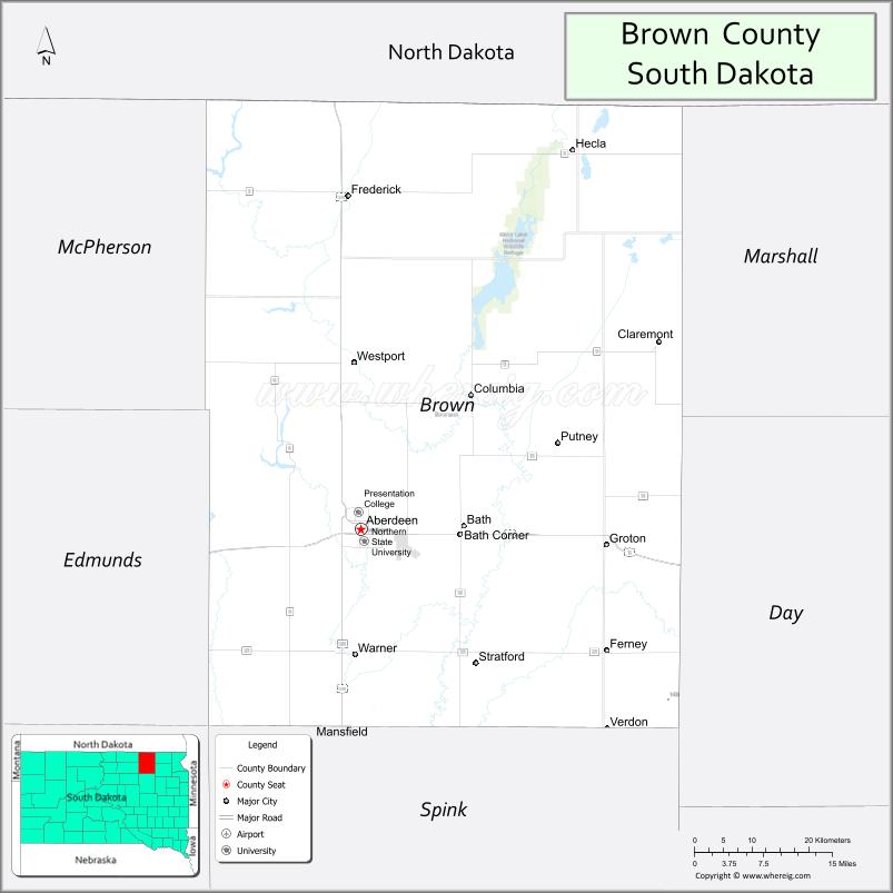
About Brown County Map, South Dakota: The map showing the county boundary, county seat, major cities, highways, water bodies and neighbouring counties.
More South Dakota Maps & Info
About Brown County, South Dakota
Brown County is a county located in the U.S. state of South Dakota. It's county seat is Aberdeen. As per 2020 census, the population of Brown County is 38101 people and population density is square miles. According to the United States Census Bureau, the county has a total area of 1,713 sq mi (4,437 km2). Brown County was established on 1879.
Brown County Facts
| Continent | North America |
| Country | United States |
| State | South Dakota |
| County Seat | Aberdeen |
| Largest City/Town | Aberdeen |
| Established | 1879 |
| Total Area | 1,731 sq mi (4,483 sq km) |
| Land Area | 1,713 sq mi (4,437 sq km) |
| Water Area | 18 sq mi (47 sq km) |
| Population | 38,301 (Census 2020) |
| Population Density | 22.4 people per sq mi |
| Time Zone | Central Time Zone (CT) |
| Major Highways | US 12, US 281, US 212, SD 37 |
| Major Rivers | James River |
| Neighboring Counties | McPherson County, Marshall County, Day County, Spink County, Edmunds County |
| Famous For | Northern State University, Aberdeen, agriculture, hunting, regional commerce |
| Top Attractions | Storybook Land, Wylie Park, Northern State University, Dacotah Prairie Museum |
| Official Website | Official Website |
About Brown County, South Dakota
Brown County is located in northeastern South Dakota in the United States and was established in 1879. The county seat and largest city is Aberdeen. The county is known for agriculture, higher education, pheasant hunting, regional healthcare, and serving as a commercial center for northeastern South Dakota.
Cities and Towns in Brown County, South Dakota
| City/Town | Population (Census 2020) | Latitude & Longitude |
|---|---|---|
| Aberdeen (county seat) | 28,495 | 45.4647°N, 98.4865°W |
| Groton | 1,358 | 45.4472°N, 98.0987°W |
| Warner | 457 | 45.3331°N, 98.4929°W |
| Frederick | 199 | 45.8325°N, 98.5056°W |
| Claremont | 104 | 45.6664°N, 98.0142°W |
| Bath | 172 | 45.4597°N, 98.3320°W |
| Columbia | 136 | 45.6328°N, 98.3118°W |
Golf Courses in Brown County, South Dakota
| Golf Course | Location | Latitude & Longitude |
|---|---|---|
| Aberdeen Golf Club | Aberdeen | 45.4421°N, 98.5094°W |
| Lee Park Golf Course | Aberdeen | 45.4667°N, 98.4795°W |
| Rolling Hills Golf Course | Aberdeen | 45.4878°N, 98.5332°W |
| Groton Country Club | Groton | 45.4460°N, 98.0932°W |
Roads and Highways in Brown County, South Dakota
Major highways connect the county to North Dakota, Minnesota, and central South Dakota.
- US Highway 12 - major east-west highway across northern South Dakota
- US Highway 281 - north-south route linking Aberdeen with North Dakota and Nebraska
- US Highway 212 - regional route serving northeastern South Dakota
- South Dakota Highway 37 - highway connecting agricultural communities
What are Neighboring Counties of Brown County
- McPherson County (northwest)
- Marshall County (northeast)
- Day County (east)
- Spink County (south)
- Edmunds County (west)
What are the Top Attractions in Brown County, South Dakota
The county offers a mix of cultural, educational, and recreational attractions.
- Storybook Land - family amusement park inspired by fairy tales and classic stories
- Wylie Park - recreation area with camping, trails, zoo attractions, and lakes
- Northern State University - public university known for education and athletics
- Dacotah Prairie Museum - exhibits covering regional history, agriculture, and pioneer heritage
- Aberdeen Aquatic Center - family water recreation facility
- Lee Park Golf Course - public golf course in Aberdeen
- Presentation College heritage sites - educational and cultural landmarks
- Richmond Lake Recreation Area nearby - boating, fishing, and camping destination
- Aberdeen Downtown District - shopping, restaurants, and entertainment venues
- Pheasant hunting areas - popular outdoor sports destination in northeastern South Dakota
- Sand Lake National Wildlife Refuge nearby - birdwatching and wildlife viewing area
- Aberdeen Community Theatre - performing arts and live entertainment venue
- Regional agricultural fairs and events - celebrating farming and rural traditions
- James River recreation areas - fishing, kayaking, and scenic prairie landscapes
What is the Distance from Brown County to Nearby Cities
The following distances are measured by road (driving).
- Aberdeen to Watertown (Codington County), South Dakota - 105 mi (169 km)
- Aberdeen to Huron (Beadle County), South Dakota - 83 mi (134 km)
- Aberdeen to Fargo (Cass County), North Dakota - 175 mi (282 km)
- Aberdeen to Pierre (Hughes County), South Dakota - 140 mi (225 km)
- Aberdeen to Sioux Falls (Minnehaha County), South Dakota - 201 mi (323 km)
- Aberdeen to Bismarck (Burleigh County), North Dakota - 211 mi (340 km)
- Aberdeen to Minneapolis (Hennepin County), Minnesota - 299 mi (481 km)
- Aberdeen to Rapid City (Pennington County), South Dakota - 352 mi (566 km)
- Aberdeen to Omaha (Douglas County), Nebraska - 352 mi (567 km)
- Aberdeen to Grand Forks (Grand Forks County), North Dakota - 251 mi (404 km)
- Aberdeen to Kansas City (Jackson County), Missouri - 545 mi (877 km)
- Aberdeen to Denver (Denver County), Colorado - 657 mi (1,057 km)
FAQs about Brown County
Brown County is located in northeastern South Dakota with Aberdeen serving as the county seat.
Brown County had a population of 38,301 according to the 2020 United States Census.
Brown County is known for Aberdeen, Northern State University, agriculture, pheasant hunting, and regional commerce.
The major highways include US Highway 12, US Highway 281, US Highway 212, and South Dakota Highway 37.
Yes, Brown County has several golf facilities including Aberdeen Golf Club and Lee Park Golf Course.
References
- QuickFacts - U.S. Census Bureau
- United States Census Bureau
- United States Geological Survey (USGS)
- National Geodetic Survey
- Official Website
- Aurora County Map
- Beadle County Map
- Bennett County Map
- Bon Homme County Map
- Brookings County Map
- Brown County Map
- Brule County Map
- Buffalo County Map
- Butte County Map
- Campbell County Map
- Charles Mix County Map
- Clark County Map
- Clay County Map
- Codington County Map
- Corson County Map
- Custer County Map
- Davison County Map
- Day County Map
- Deuel County Map
- Dewey County Map
- Douglas County Map
- Edmunds County Map
- Fall River County Map
- Faulk County Map
- Grant County Map
- Gregory County Map
- Haakon County Map
- Hamlin County Map
- Hand County Map
- Hanson County Map
- Harding County Map
- Hughes County Map
- Hutchinson County Map
- Hyde County Map
- Jackson County Map
- Jerauld County Map
- Jones County Map
- Kingsbury County Map
- Lake County Map
- Lawrence County Map
- Lincoln County Map
- Lyman County Map
- McCook County Map
- McPherson County Map
- Marshall County Map
- Meade County Map
- Mellette County Map
- Miner County Map
- Minnehaha County Map
- Moody County Map
- Oglala Lakota County Map
- Pennington County Map
- Perkins County Map
- Potter County Map
- Roberts County Map
- Sanborn County Map
- Spink County Map
- Stanley County Map
- Sully County Map
- Todd County Map
- Tripp County Map
- Turner County Map
- Union County Map
- Walworth County Map
- Yankton County Map
- Ziebach County Map
- Alabama Counties
- Alaska boroughs
- Arizona Counties
- Arkansas Counties
- California County Map
- Colorado Counties
- Connecticut Counties
- Delaware Counties
- Florida County Map
- Georgia County Map
- Hawaii Counties
- Idaho Counties
- Illinois Counties
- Indiana Counties
- Iowa Counties
- Kansas Counties
- Kentucky Counties
- Louisiana Counties
- Maine Counties
- Maryland Counties
- Massachusetts Counties
- Michigan County Map
- Minnesota Counties
- Mississippi Counties
- Missouri Counties
- Montana Counties
- Nebraska Counties
- Nevada Counties
- New York Counties
- New Hampshire Counties
- New Jersey Counties
- New Mexico Counties
- North Carolina Counties
- North Dakota Counties
- Ohio County Map
- Oklahoma Counties
- Oregon Counties
- Pennsylvania Counties
- Rhode Island Counties
- South Carolina Counties
- South Dakota Counties
- Map of Tennessee
- Texas County Map
- Utah Counties
- Vermont Counties
- Virginia Counties
- Washington Counties
- West Virginia Counties
- Wisconsin Counties
- Wyoming Counties