Written and Fact-checked by Whereig Editors, Reviewed by Mukesh Kumar| Last Updated On: May 11, 2026
Map of Deuel County - Deuel County is a county located in the U.S. state of South Dakota. Deuel County Map showing cities, highways, important places and water bodies. Get Where is Deuel County located in the map, major cities in Deuel county, population, areas, and places of interest.
Map of Deuel County, South Dakota
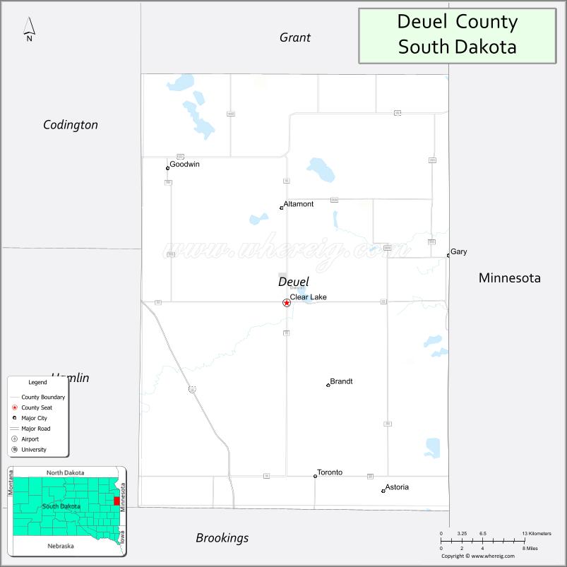
About Deuel County Map, South Dakota: The map showing the county boundary, county seat, major cities, highways, water bodies and neighbouring counties.
More South Dakota Maps & Info
About Deuel County, South Dakota
Deuel County is a county located in the U.S. state of South Dakota. It's county seat is Clear Lake. As per 2020 census, the population of Deuel County is 4272 people and population density is square miles. According to the United States Census Bureau, the county has a total area of 624 sq mi (1,616 km2). Deuel County was established on 1862.
Deuel County Facts
| Continent | North America |
| Country | United States |
| State | South Dakota |
| County Seat | Clear Lake |
| Largest City/Town | Clear Lake |
| Established | 1862 |
| Total Area | 637 sq mi (1,650 sq km) |
| Land Area | 623 sq mi (1,614 sq km) |
| Water Area | 14 sq mi (36 sq km) |
| Population | 4,295 (Census 2020) |
| Population Density | 6.9 people per sq mi |
| Time Zone | Central Time Zone (CT) |
| Major Highways | Interstate 29, US 212, SD 15 |
| Major Rivers | Big Sioux River nearby |
| Neighboring Counties | Grant County, Codington County, Hamlin County, Brookings County, Lincoln County (MN), Yellow Medicine County (MN) |
| Famous For | Clear Lake, agriculture, lakes and outdoor recreation, Interstate 29 corridor |
| Top Attractions | Clear Lake City Park, Lake Cochrane Recreation Area, fishing lakes, camping and hunting areas |
| Official Website | Official Website |
About Deuel County, South Dakota
Deuel County is located in eastern South Dakota in the United States and was established in 1862. The county seat and largest city is Clear Lake. The county is known for agriculture, scenic prairie lakes, outdoor recreation, and its location along Interstate 29 near the Minnesota border.
Cities and Towns in Deuel County, South Dakota
| City/Town | Population (Census 2020) | Latitude & Longitude |
|---|---|---|
| Clear Lake (county seat) | 1,273 | 44.7561°N, 96.6826°W |
| Gary | 227 | 44.7947°N, 96.4576°W |
| Goodwin | 143 | 44.8725°N, 96.8301°W |
| Toronto | 180 | 44.5794°N, 96.7012°W |
| Brandt | 107 | 44.6664°N, 96.7487°W |
| Astoria | 139 | 44.5603°N, 96.5601°W |
Golf Courses in Deuel County, South Dakota
| Golf Course | Location | Latitude & Longitude |
|---|---|---|
| Clear Lake Country Club | Clear Lake | 44.7604°N, 96.6908°W |
| Prairie Winds Golf Club nearby | Milbank | 45.2185°N, 96.6334°W |
| Watertown Country Club nearby | Watertown | 44.8875°N, 97.1156°W |
| Brookings Country Club nearby | Brookings | 44.3006°N, 96.7889°W |
Roads and Highways in Deuel County, South Dakota
Major highways connect the county to eastern South Dakota, Minnesota, and Interstate 29 regional routes.
- Interstate 29 - major north-south interstate through eastern South Dakota
- US Highway 212 - east-west route linking communities across northern South Dakota
- South Dakota Highway 15 - regional roadway connecting agricultural communities and recreation areas
What are Neighboring Counties of Deuel County
- Grant County (north)
- Codington County (west)
- Hamlin County (southwest)
- Brookings County (south)
- Lincoln County, Minnesota (east)
- Yellow Medicine County, Minnesota (southeast)
What are the Top Attractions in Deuel County, South Dakota
The county offers a mix of lake recreation, outdoor adventure, and prairie scenery.
- Clear Lake City Park - lakeside recreation, picnicking, and family activities
- Lake Cochrane Recreation Area - boating, camping, fishing, and swimming destination
- Fishing lakes throughout the county - walleye, perch, and northern pike fishing opportunities
- Camping and hunting areas - pheasant hunting and prairie outdoor recreation
- Clear Lake Downtown District - local restaurants, shops, and community attractions
- Big Stone Lake nearby - boating, fishing, and scenic recreation area
- Prairie landscapes and scenic drives - Great Plains views and farmland scenery
- Birdwatching and wetland habitats - migratory bird viewing opportunities
- Golf and recreation facilities - outdoor sports and family entertainment
- Community fairs and seasonal festivals - celebrating local culture and agriculture
- Snowmobiling and winter recreation trails - cold-weather outdoor activities
- Historic farming communities - reflecting South Dakota agricultural heritage
- RV parks and campgrounds - convenient stops along Interstate 29
- Regional wildlife viewing areas - prairie and wetland ecosystems
What is the Distance from Deuel County to Nearby Cities
The following distances are measured by road (driving).
- Clear Lake to Watertown (Codington County), South Dakota - 37 mi (60 km)
- Clear Lake to Brookings (Brookings County), South Dakota - 42 mi (68 km)
- Clear Lake to Sioux Falls (Minnehaha County), South Dakota - 103 mi (166 km)
- Clear Lake to Aberdeen (Brown County), South Dakota - 129 mi (208 km)
- Clear Lake to Fargo (Cass County), North Dakota - 171 mi (275 km)
- Clear Lake to Minneapolis (Hennepin County), Minnesota - 183 mi (295 km)
- Clear Lake to Pierre (Hughes County), South Dakota - 245 mi (394 km)
- Clear Lake to Omaha (Douglas County), Nebraska - 258 mi (415 km)
- Clear Lake to Rapid City (Pennington County), South Dakota - 450 mi (724 km)
- Clear Lake to Bismarck (Burleigh County), North Dakota - 333 mi (536 km)
- Clear Lake to Kansas City (Jackson County), Missouri - 486 mi (782 km)
- Clear Lake to Denver (Denver County), Colorado - 663 mi (1,067 km)
FAQs about Deuel County
Deuel County is located in eastern South Dakota near the Minnesota border along Interstate 29.
Deuel County had a population of 4,295 according to the 2020 United States Census.
Deuel County is known for Clear Lake, outdoor recreation, prairie lakes, and agricultural landscapes.
The major highways include Interstate 29, US Highway 212, and South Dakota Highway 15.
Yes, Deuel County has golf facilities including Clear Lake Country Club and nearby regional golf courses.
References
- QuickFacts - U.S. Census Bureau
- United States Census Bureau
- United States Geological Survey (USGS)
- National Geodetic Survey
- Official Website
- Aurora County Map
- Beadle County Map
- Bennett County Map
- Bon Homme County Map
- Brookings County Map
- Brown County Map
- Brule County Map
- Buffalo County Map
- Butte County Map
- Campbell County Map
- Charles Mix County Map
- Clark County Map
- Clay County Map
- Codington County Map
- Corson County Map
- Custer County Map
- Davison County Map
- Day County Map
- Deuel County Map
- Dewey County Map
- Douglas County Map
- Edmunds County Map
- Fall River County Map
- Faulk County Map
- Grant County Map
- Gregory County Map
- Haakon County Map
- Hamlin County Map
- Hand County Map
- Hanson County Map
- Harding County Map
- Hughes County Map
- Hutchinson County Map
- Hyde County Map
- Jackson County Map
- Jerauld County Map
- Jones County Map
- Kingsbury County Map
- Lake County Map
- Lawrence County Map
- Lincoln County Map
- Lyman County Map
- McCook County Map
- McPherson County Map
- Marshall County Map
- Meade County Map
- Mellette County Map
- Miner County Map
- Minnehaha County Map
- Moody County Map
- Oglala Lakota County Map
- Pennington County Map
- Perkins County Map
- Potter County Map
- Roberts County Map
- Sanborn County Map
- Spink County Map
- Stanley County Map
- Sully County Map
- Todd County Map
- Tripp County Map
- Turner County Map
- Union County Map
- Walworth County Map
- Yankton County Map
- Ziebach County Map
- Alabama Counties
- Alaska boroughs
- Arizona Counties
- Arkansas Counties
- California County Map
- Colorado Counties
- Connecticut Counties
- Delaware Counties
- Florida County Map
- Georgia County Map
- Hawaii Counties
- Idaho Counties
- Illinois Counties
- Indiana Counties
- Iowa Counties
- Kansas Counties
- Kentucky Counties
- Louisiana Counties
- Maine Counties
- Maryland Counties
- Massachusetts Counties
- Michigan County Map
- Minnesota Counties
- Mississippi Counties
- Missouri Counties
- Montana Counties
- Nebraska Counties
- Nevada Counties
- New York Counties
- New Hampshire Counties
- New Jersey Counties
- New Mexico Counties
- North Carolina Counties
- North Dakota Counties
- Ohio County Map
- Oklahoma Counties
- Oregon Counties
- Pennsylvania Counties
- Rhode Island Counties
- South Carolina Counties
- South Dakota Counties
- Map of Tennessee
- Texas County Map
- Utah Counties
- Vermont Counties
- Virginia Counties
- Washington Counties
- West Virginia Counties
- Wisconsin Counties
- Wyoming Counties