Written and Fact-checked by Whereig Editors, Reviewed by Mukesh Kumar| Last Updated On: May 11, 2026
Map of Gregory County - Gregory County is a county located in the U.S. state of South Dakota. Gregory County Map showing cities, highways, important places and water bodies. Get Where is Gregory County located in the map, major cities in Gregory county, population, areas, and places of interest.
Map of Gregory County, South Dakota
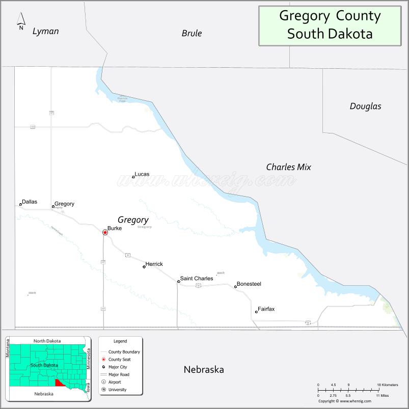
About Gregory County Map, South Dakota: The map showing the county boundary, county seat, major cities, highways, water bodies and neighbouring counties.
More South Dakota Maps & Info
About Gregory County, South Dakota
Gregory County is a county located in the U.S. state of South Dakota. It's county seat is Burke. As per 2020 census, the population of Gregory County is 3977 people and population density is square miles. According to the United States Census Bureau, the county has a total area of 1,016 sq mi (2,631 km2). Gregory County was established on 1862.
Gregory County Facts
| Continent | North America |
| Country | United States |
| State | South Dakota |
| County Seat | Burke |
| Largest City/Town | Winner |
| Established | 1862 |
| Total Area | 1,054 sq mi (2,729 sq km) |
| Land Area | 1,015 sq mi (2,629 sq km) |
| Water Area | 39 sq mi (100 sq km) |
| Population | 4,196 (Census 2020) |
| Population Density | 4.1 people per sq mi |
| Time Zone | Central Time Zone (CT) |
| Major Highways | US 18, US 183, SD 47 |
| Major Rivers | Missouri River nearby |
| Neighboring Counties | Charles Mix County, Tripp County, Lyman County, Brule County, Boyd County (NE), Keya Paha County (NE) |
| Famous For | Agriculture, pheasant hunting, Missouri River recreation, prairie landscapes |
| Top Attractions | Missouri River recreation areas, Burke attractions, hunting and fishing destinations, local museums |
| Official Website | Official Website |
About Gregory County, South Dakota
Gregory County is located in south-central South Dakota in the United States and was established in 1862. The county seat is Burke, while Winner is the largest nearby regional community serving the area. The county is known for agriculture, pheasant hunting, prairie landscapes, and outdoor recreation near the Missouri River region.
Cities and Towns in Gregory County, South Dakota
| City/Town | Population (Census 2020) | Latitude & Longitude |
|---|---|---|
| Burke (county seat) | 555 | 43.1814°N, 99.2923°W |
| Bonesteel | 258 | 43.0742°N, 98.9384°W |
| Dallas | 84 | 43.2239°N, 99.5687°W |
| Herrick | 85 | 43.1186°N, 99.1867°W |
| Fairfax | 99 | 43.0214°N, 98.8887°W |
| Parmelee nearby | 537 | 43.3211°N, 99.3148°W |
Golf Courses in Gregory County, South Dakota
| Golf Course | Location | Latitude & Longitude |
|---|---|---|
| Winner Country Club nearby | Winner | 43.3822°N, 99.8618°W |
| Springfield Golf Course nearby | Springfield | 42.8548°N, 97.9038°W |
| Lakeview Golf Course nearby | Mitchell | 43.7145°N, 98.0224°W |
| Southern Hills Golf Course nearby | Hot Springs | 43.4329°N, 103.4832°W |
Roads and Highways in Gregory County, South Dakota
Major highways connect the county to south-central South Dakota, Nebraska, and Missouri River recreation areas.
- US Highway 18 - major east-west route across southern South Dakota
- US Highway 183 - north-south highway connecting prairie communities
- South Dakota Highway 47 - regional route serving agricultural and recreation areas
What are Neighboring Counties of Gregory County
- Brule County (north)
- Lyman County (northwest)
- Tripp County (west)
- Charles Mix County (east)
- Boyd County, Nebraska (south)
- Keya Paha County, Nebraska (southwest)
What are the Top Attractions in Gregory County, South Dakota
The county offers a mix of outdoor recreation, hunting opportunities, and prairie scenery.
- Missouri River recreation areas - boating, fishing, camping, and water sports destinations
- Burke community attractions - local parks, restaurants, and seasonal events
- Hunting and fishing destinations - famous pheasant hunting and prairie recreation
- Local museums and heritage attractions - showcasing regional ranching and farming history
- Prairie scenic drives - rolling grasslands and Great Plains landscapes
- Birdwatching and wildlife habitats - migratory bird viewing opportunities
- Camping and RV parks near recreation areas - family outdoor destinations
- Fishing lakes and reservoirs nearby - walleye and catfish fishing opportunities
- Regional rodeos and county fairs - celebrating local western and agricultural culture
- Historic rural communities - reflecting South Dakota settlement heritage
- Photography and sunset viewing across prairie landscapes - scenic countryside experiences
- Nearby Winner attractions - shopping, golf, and entertainment facilities
- Snowmobiling and seasonal recreation activities - winter outdoor adventures
- Wildlife viewing areas near the Missouri River region - natural prairie ecosystems
What is the Distance from Gregory County to Nearby Cities
The following distances are measured by road (driving).
- Burke to Winner (Tripp County), South Dakota - 28 mi (45 km)
- Burke to Mitchell (Davison County), South Dakota - 112 mi (180 km)
- Burke to Pierre (Hughes County), South Dakota - 137 mi (220 km)
- Burke to Sioux Falls (Minnehaha County), South Dakota - 178 mi (286 km)
- Burke to North Platte (Lincoln County), Nebraska - 226 mi (364 km)
- Burke to Omaha (Douglas County), Nebraska - 268 mi (431 km)
- Burke to Rapid City (Pennington County), South Dakota - 273 mi (439 km)
- Burke to Fargo (Cass County), North Dakota - 416 mi (669 km)
- Burke to Denver (Denver County), Colorado - 487 mi (784 km)
- Burke to Minneapolis (Hennepin County), Minnesota - 394 mi (634 km)
- Burke to Kansas City (Jackson County), Missouri - 472 mi (760 km)
- Burke to Billings (Yellowstone County), Montana - 519 mi (835 km)
FAQs about Gregory County
Gregory County is located in south-central South Dakota near the Missouri River region.
Gregory County had a population of 4,196 according to the 2020 United States Census.
Gregory County is known for pheasant hunting, agriculture, prairie scenery, and Missouri River recreation.
The major highways include US Highway 18, US Highway 183, and South Dakota Highway 47.
Yes, Gregory County has access to nearby golf facilities including Winner Country Club and regional golf courses.
References
- QuickFacts - U.S. Census Bureau
- United States Census Bureau
- United States Geological Survey (USGS)
- National Geodetic Survey
- Official Website
- Aurora County Map
- Beadle County Map
- Bennett County Map
- Bon Homme County Map
- Brookings County Map
- Brown County Map
- Brule County Map
- Buffalo County Map
- Butte County Map
- Campbell County Map
- Charles Mix County Map
- Clark County Map
- Clay County Map
- Codington County Map
- Corson County Map
- Custer County Map
- Davison County Map
- Day County Map
- Deuel County Map
- Dewey County Map
- Douglas County Map
- Edmunds County Map
- Fall River County Map
- Faulk County Map
- Grant County Map
- Gregory County Map
- Haakon County Map
- Hamlin County Map
- Hand County Map
- Hanson County Map
- Harding County Map
- Hughes County Map
- Hutchinson County Map
- Hyde County Map
- Jackson County Map
- Jerauld County Map
- Jones County Map
- Kingsbury County Map
- Lake County Map
- Lawrence County Map
- Lincoln County Map
- Lyman County Map
- McCook County Map
- McPherson County Map
- Marshall County Map
- Meade County Map
- Mellette County Map
- Miner County Map
- Minnehaha County Map
- Moody County Map
- Oglala Lakota County Map
- Pennington County Map
- Perkins County Map
- Potter County Map
- Roberts County Map
- Sanborn County Map
- Spink County Map
- Stanley County Map
- Sully County Map
- Todd County Map
- Tripp County Map
- Turner County Map
- Union County Map
- Walworth County Map
- Yankton County Map
- Ziebach County Map
- Alabama Counties
- Alaska boroughs
- Arizona Counties
- Arkansas Counties
- California County Map
- Colorado Counties
- Connecticut Counties
- Delaware Counties
- Florida County Map
- Georgia County Map
- Hawaii Counties
- Idaho Counties
- Illinois Counties
- Indiana Counties
- Iowa Counties
- Kansas Counties
- Kentucky Counties
- Louisiana Counties
- Maine Counties
- Maryland Counties
- Massachusetts Counties
- Michigan County Map
- Minnesota Counties
- Mississippi Counties
- Missouri Counties
- Montana Counties
- Nebraska Counties
- Nevada Counties
- New York Counties
- New Hampshire Counties
- New Jersey Counties
- New Mexico Counties
- North Carolina Counties
- North Dakota Counties
- Ohio County Map
- Oklahoma Counties
- Oregon Counties
- Pennsylvania Counties
- Rhode Island Counties
- South Carolina Counties
- South Dakota Counties
- Map of Tennessee
- Texas County Map
- Utah Counties
- Vermont Counties
- Virginia Counties
- Washington Counties
- West Virginia Counties
- Wisconsin Counties
- Wyoming Counties