Written and Fact-checked by Whereig Editors, Reviewed by Mukesh Kumar| Last Updated On: May 11, 2026
Map of Butte County - Butte County is a county located in the U.S. state of South Dakota. Butte County Map showing cities, highways, important places and water bodies. Get Where is Butte County located in the map, major cities in Butte county, population, areas, and places of interest.
Map of Butte County, South Dakota
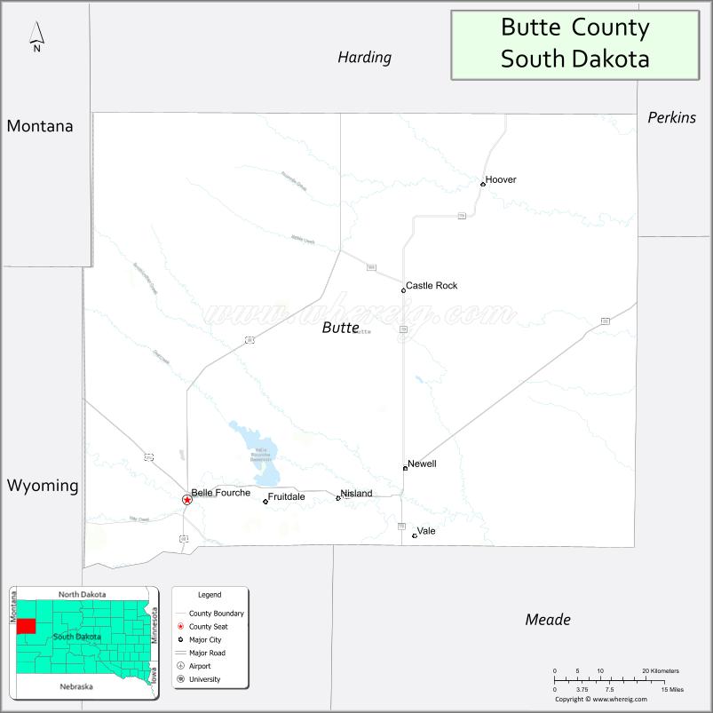
About Butte County Map, South Dakota: The map showing the county boundary, county seat, major cities, highways, water bodies and neighbouring counties.
More South Dakota Maps & Info
About Butte County, South Dakota
Butte County is a county located in the U.S. state of South Dakota. It's county seat is Belle Fourche. As per 2020 census, the population of Butte County is 10456 people and population density is square miles. According to the United States Census Bureau, the county has a total area of 2,249 sq mi (5,825 km2). Butte County was established on 1883.
Butte County Facts
| Continent | North America |
| Country | United States |
| State | South Dakota |
| County Seat | Belle Fourche |
| Largest City/Town | Belle Fourche |
| Established | 1883 |
| Total Area | 2,266 sq mi (5,869 sq km) |
| Land Area | 2,250 sq mi (5,827 sq km) |
| Water Area | 16 sq mi (41 sq km) |
| Population | 10,243 (Census 2020) |
| Population Density | 4.6 people per sq mi |
| Time Zone | Mountain Time Zone (MT) |
| Major Highways | Interstate 90, US 85, US 212, SD 34 |
| Major Rivers | Belle Fourche River |
| Neighboring Counties | Lawrence County, Meade County, Harding County, Crook County (WY), Campbell County (WY) |
| Famous For | Belle Fourche, geographic center of the United States nearby, ranching, Black Hills region |
| Top Attractions | Geographic Center Monument, Belle Fourche River, Tri-State Museum, Black Hills access |
| Official Website | Official Website |
About Butte County, South Dakota
Butte County is located in northwestern South Dakota in the United States and was established in 1883. The county seat and largest city is Belle Fourche. The county is known for ranching, western heritage, scenic prairie landscapes, and being near the geographic center of the United States.
Cities and Towns in Butte County, South Dakota
| City/Town | Population (Census 2020) | Latitude & Longitude |
|---|---|---|
| Belle Fourche (county seat) | 5,594 | 44.6714°N, 103.8521°W |
| Nisland | 232 | 44.6611°N, 103.5399°W |
| Newell | 603 | 44.7153°N, 103.4205°W |
| Vale | 134 | 44.6328°N, 103.3846°W |
| Fruitdale | 64 | 44.6831°N, 103.7490°W |
| Sturgis nearby | 7,020 | 44.4097°N, 103.5091°W |
Golf Courses in Butte County, South Dakota
| Golf Course | Location | Latitude & Longitude |
|---|---|---|
| Belle Fourche Country Club | Belle Fourche | 44.6798°N, 103.8619°W |
| Elks Golf Course nearby | Spearfish | 44.4947°N, 103.8720°W |
| Sturgis Country Club nearby | Sturgis | 44.4188°N, 103.5097°W |
| Prairie Hills Golf Course nearby | Sundance, Wyoming | 44.4078°N, 104.3724°W |
Roads and Highways in Butte County, South Dakota
Major highways connect the county to the Black Hills region, Wyoming, and Interstate 90.
- Interstate 90 - major east-west interstate serving western South Dakota
- US Highway 85 - north-south route linking Belle Fourche with Wyoming and North Dakota
- US Highway 212 - regional highway across northern South Dakota
- South Dakota Highway 34 - scenic route connecting ranching communities
What are Neighboring Counties of Butte County
- Harding County (north)
- Meade County (south)
- Lawrence County (southwest)
- Crook County, Wyoming (west)
- Campbell County, Wyoming (northwest)
What are the Top Attractions in Butte County, South Dakota
The county offers a mix of western heritage, outdoor recreation, and scenic attractions.
- Geographic Center of the Nation Monument - landmark marking the geographic center of the United States
- Belle Fourche River recreation areas - fishing, kayaking, and scenic views
- Tri-State Museum and Visitor Center - exhibits on regional western and ranching history
- Black Hills access routes - gateway to hiking, camping, and scenic drives
- Belle Fourche Downtown District - western-themed shops, restaurants, and local attractions
- Historic rodeo and ranching events - celebrating cowboy heritage and livestock traditions
- Orman Dam and Belle Fourche Reservoir nearby - boating, fishing, and camping destination
- Sturgis Motorcycle Rally nearby - major regional tourism event
- Spearfish Canyon nearby - scenic canyon drives and waterfalls
- Prairie wildlife viewing areas - habitat for deer, antelope, and birds
- Regional hunting opportunities - pheasant, deer, and upland game hunting
- Devils Tower National Monument nearby in Wyoming - famous geological landmark
- Rural scenic drives - rolling plains and ranch landscapes
- Local fairs and rodeos - seasonal community events and entertainment
What is the Distance from Butte County to Nearby Cities
The following distances are measured by road (driving).
- Belle Fourche to Spearfish (Lawrence County), South Dakota - 12 mi (19 km)
- Belle Fourche to Sturgis (Meade County), South Dakota - 28 mi (45 km)
- Belle Fourche to Rapid City (Pennington County), South Dakota - 57 mi (92 km)
- Belle Fourche to Deadwood (Lawrence County), South Dakota - 24 mi (39 km)
- Belle Fourche to Gillette (Campbell County), Wyoming - 82 mi (132 km)
- Belle Fourche to Casper (Natrona County), Wyoming - 191 mi (307 km)
- Belle Fourche to Pierre (Hughes County), South Dakota - 188 mi (303 km)
- Belle Fourche to Sioux Falls (Minnehaha County), South Dakota - 360 mi (579 km)
- Belle Fourche to Billings (Yellowstone County), Montana - 272 mi (438 km)
- Belle Fourche to Bismarck (Burleigh County), North Dakota - 291 mi (468 km)
- Belle Fourche to Denver (Denver County), Colorado - 392 mi (631 km)
- Belle Fourche to Minneapolis (Hennepin County), Minnesota - 632 mi (1,017 km)
FAQs about Butte County
Butte County is located in northwestern South Dakota near the Wyoming border and Black Hills region.
Butte County had a population of 10,243 according to the 2020 United States Census.
Butte County is known for Belle Fourche, ranching, western heritage, and the geographic center of the United States nearby.
The major highways include Interstate 90, US Highway 85, US Highway 212, and South Dakota Highway 34.
Yes, Butte County has golf facilities including Belle Fourche Country Club and nearby regional golf courses.
References
- QuickFacts - U.S. Census Bureau
- United States Census Bureau
- United States Geological Survey (USGS)
- National Geodetic Survey
- Official Website
- Aurora County Map
- Beadle County Map
- Bennett County Map
- Bon Homme County Map
- Brookings County Map
- Brown County Map
- Brule County Map
- Buffalo County Map
- Butte County Map
- Campbell County Map
- Charles Mix County Map
- Clark County Map
- Clay County Map
- Codington County Map
- Corson County Map
- Custer County Map
- Davison County Map
- Day County Map
- Deuel County Map
- Dewey County Map
- Douglas County Map
- Edmunds County Map
- Fall River County Map
- Faulk County Map
- Grant County Map
- Gregory County Map
- Haakon County Map
- Hamlin County Map
- Hand County Map
- Hanson County Map
- Harding County Map
- Hughes County Map
- Hutchinson County Map
- Hyde County Map
- Jackson County Map
- Jerauld County Map
- Jones County Map
- Kingsbury County Map
- Lake County Map
- Lawrence County Map
- Lincoln County Map
- Lyman County Map
- McCook County Map
- McPherson County Map
- Marshall County Map
- Meade County Map
- Mellette County Map
- Miner County Map
- Minnehaha County Map
- Moody County Map
- Oglala Lakota County Map
- Pennington County Map
- Perkins County Map
- Potter County Map
- Roberts County Map
- Sanborn County Map
- Spink County Map
- Stanley County Map
- Sully County Map
- Todd County Map
- Tripp County Map
- Turner County Map
- Union County Map
- Walworth County Map
- Yankton County Map
- Ziebach County Map
- Alabama Counties
- Alaska boroughs
- Arizona Counties
- Arkansas Counties
- California County Map
- Colorado Counties
- Connecticut Counties
- Delaware Counties
- Florida County Map
- Georgia County Map
- Hawaii Counties
- Idaho Counties
- Illinois Counties
- Indiana Counties
- Iowa Counties
- Kansas Counties
- Kentucky Counties
- Louisiana Counties
- Maine Counties
- Maryland Counties
- Massachusetts Counties
- Michigan County Map
- Minnesota Counties
- Mississippi Counties
- Missouri Counties
- Montana Counties
- Nebraska Counties
- Nevada Counties
- New York Counties
- New Hampshire Counties
- New Jersey Counties
- New Mexico Counties
- North Carolina Counties
- North Dakota Counties
- Ohio County Map
- Oklahoma Counties
- Oregon Counties
- Pennsylvania Counties
- Rhode Island Counties
- South Carolina Counties
- South Dakota Counties
- Map of Tennessee
- Texas County Map
- Utah Counties
- Vermont Counties
- Virginia Counties
- Washington Counties
- West Virginia Counties
- Wisconsin Counties
- Wyoming Counties