Written and Fact-checked by Whereig Editors, Reviewed by Mukesh Kumar| Last Updated On: May 11, 2026
Map of Charles Mix County - Charles Mix County is a county located in the U.S. state of South Dakota. Charles Mix County Map showing cities, highways, important places and water bodies. Get Where is Charles Mix County located in the map, major cities in Charles Mix county, population, areas, and places of interest.
Map of Charles Mix County, South Dakota
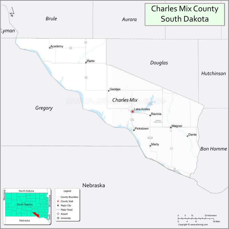
About Charles Mix County Map, South Dakota: The map showing the county boundary, county seat, major cities, highways, water bodies and neighbouring counties.
More South Dakota Maps & Info
About Charles Mix County, South Dakota
Charles Mix County is a county located in the U.S. state of South Dakota. It's county seat is Lake Andes. As per 2020 census, the population of Charles Mix County is 9163 people and population density is square miles. According to the United States Census Bureau, the county has a total area of 1,098 sq mi (2,844 km2). Charles Mix County was established on 1862.
Charles Mix County Facts
| Continent | North America |
| Country | United States |
| State | South Dakota |
| County Seat | Lake Andes |
| Largest City/Town | Wagner |
| Established | 1862 |
| Total Area | 1,150 sq mi (2,979 sq km) |
| Land Area | 1,097 sq mi (2,841 sq km) |
| Water Area | 53 sq mi (137 sq km) |
| Population | 9,373 (Census 2020) |
| Population Density | 8.5 people per sq mi |
| Time Zone | Central Time Zone (CT) |
| Major Highways | US 18, US 281, SD 46, SD 50 |
| Major Rivers | Missouri River |
| Neighboring Counties | Brule County, Douglas County, Gregory County, Hutchinson County, Bon Homme County, Knox County (NE) |
| Famous For | Missouri River recreation, Yankton Sioux Tribe, fishing, Native American heritage |
| Top Attractions | Fort Randall Dam nearby, Lake Andes National Wildlife Refuge, Missouri River recreation, Wagner community attractions |
| Official Website | Official Website |
About Charles Mix County, South Dakota
Charles Mix County is located in southeastern South Dakota in the United States and was established in 1862. The county seat is Lake Andes, while Wagner is the largest city in the county. The county is known for Missouri River recreation, Native American heritage, wildlife refuges, and agricultural communities.
Cities and Towns in Charles Mix County, South Dakota
| City/Town | Population (Census 2020) | Latitude & Longitude |
|---|---|---|
| Wagner | 1,566 | 43.0797°N, 98.2934°W |
| Lake Andes (county seat) | 879 | 43.1542°N, 98.5412°W |
| Geddes | 252 | 43.2675°N, 98.6995°W |
| Platte nearby | 1,222 | 43.3875°N, 98.8448°W |
| Pickstown | 230 | 43.0675°N, 98.5201°W |
| Marty | 634 | 43.0919°N, 98.4273°W |
Golf Courses in Charles Mix County, South Dakota
| Golf Course | Location | Latitude & Longitude |
|---|---|---|
| Lakeview Golf Course | Lake Andes | 43.1560°N, 98.5450°W |
| Platte Golf Club nearby | Platte | 43.3892°N, 98.8456°W |
| Springfield Golf Course nearby | Springfield | 42.8548°N, 97.9038°W |
| Winner Country Club nearby | Winner | 43.3765°N, 99.8598°W |
Roads and Highways in Charles Mix County, South Dakota
Major highways connect the county to southeastern South Dakota and Missouri River recreation areas.
- US Highway 18 - major east-west route across southern South Dakota
- US Highway 281 - north-south highway serving agricultural and river communities
- South Dakota Highway 46 - regional route connecting local towns
- South Dakota Highway 50 - roadway linking nearby recreation areas and communities
What are Neighboring Counties of Charles Mix County
- Brule County (north)
- Douglas County (northeast)
- Hutchinson County (east)
- Bon Homme County (southeast)
- Gregory County (west)
- Knox County, Nebraska (south)
What are the Top Attractions in Charles Mix County, South Dakota
The county offers a mix of outdoor recreation, cultural heritage, and wildlife attractions.
- Fort Randall Dam nearby - major Missouri River dam with scenic overlooks and recreation
- Lake Andes National Wildlife Refuge - birdwatching, wildlife viewing, and nature trails
- Missouri River recreation areas - boating, fishing, kayaking, and camping opportunities
- Wagner community attractions - local parks, shops, and cultural events
- Yankton Sioux Tribe heritage sites - Native American history and cultural experiences
- Lake Francis Case nearby - reservoir recreation and fishing destination
- Fishing and hunting areas - popular for walleye fishing and pheasant hunting
- Pickstown recreation areas - riverfront camping and boating access
- Marty community cultural attractions - tribal heritage and local events
- Scenic prairie and river valley drives - panoramic South Dakota landscapes
- Bird migration viewing areas - wetlands and waterfowl habitats
- Regional rodeos and fairs - celebrating ranching and agricultural traditions
- Fort Randall Casino nearby - entertainment and gaming destination
- Camping and RV parks - outdoor recreation near the Missouri River
What is the Distance from Charles Mix County to Nearby Cities
The following distances are measured by road (driving).
- Wagner to Mitchell (Davison County), South Dakota - 82 mi (132 km)
- Wagner to Yankton (Yankton County), South Dakota - 53 mi (85 km)
- Lake Andes to Chamberlain (Brule County), South Dakota - 61 mi (98 km)
- Wagner to Sioux Falls (Minnehaha County), South Dakota - 121 mi (195 km)
- Wagner to Pierre (Hughes County), South Dakota - 166 mi (267 km)
- Wagner to Omaha (Douglas County), Nebraska - 207 mi (333 km)
- Wagner to Sioux City (Woodbury County), Iowa - 116 mi (187 km)
- Wagner to Rapid City (Pennington County), South Dakota - 345 mi (555 km)
- Wagner to Lincoln (Lancaster County), Nebraska - 221 mi (356 km)
- Wagner to Fargo (Cass County), North Dakota - 368 mi (592 km)
- Wagner to Minneapolis (Hennepin County), Minnesota - 331 mi (533 km)
- Wagner to Denver (Denver County), Colorado - 551 mi (887 km)
FAQs about Charles Mix County
Charles Mix County is located in southeastern South Dakota along the Missouri River.
Charles Mix County had a population of 9,373 according to the 2020 United States Census.
Charles Mix County is known for Missouri River recreation, Native American heritage, wildlife refuges, and fishing.
The major highways include US Highway 18, US Highway 281, South Dakota Highway 46, and Highway 50.
Yes, Charles Mix County has golf facilities including Lakeview Golf Course and nearby regional golf clubs.
References
- QuickFacts - U.S. Census Bureau
- United States Census Bureau
- United States Geological Survey (USGS)
- National Geodetic Survey
- Official Website
- Aurora County Map
- Beadle County Map
- Bennett County Map
- Bon Homme County Map
- Brookings County Map
- Brown County Map
- Brule County Map
- Buffalo County Map
- Butte County Map
- Campbell County Map
- Charles Mix County Map
- Clark County Map
- Clay County Map
- Codington County Map
- Corson County Map
- Custer County Map
- Davison County Map
- Day County Map
- Deuel County Map
- Dewey County Map
- Douglas County Map
- Edmunds County Map
- Fall River County Map
- Faulk County Map
- Grant County Map
- Gregory County Map
- Haakon County Map
- Hamlin County Map
- Hand County Map
- Hanson County Map
- Harding County Map
- Hughes County Map
- Hutchinson County Map
- Hyde County Map
- Jackson County Map
- Jerauld County Map
- Jones County Map
- Kingsbury County Map
- Lake County Map
- Lawrence County Map
- Lincoln County Map
- Lyman County Map
- McCook County Map
- McPherson County Map
- Marshall County Map
- Meade County Map
- Mellette County Map
- Miner County Map
- Minnehaha County Map
- Moody County Map
- Oglala Lakota County Map
- Pennington County Map
- Perkins County Map
- Potter County Map
- Roberts County Map
- Sanborn County Map
- Spink County Map
- Stanley County Map
- Sully County Map
- Todd County Map
- Tripp County Map
- Turner County Map
- Union County Map
- Walworth County Map
- Yankton County Map
- Ziebach County Map
- Alabama Counties
- Alaska boroughs
- Arizona Counties
- Arkansas Counties
- California County Map
- Colorado Counties
- Connecticut Counties
- Delaware Counties
- Florida County Map
- Georgia County Map
- Hawaii Counties
- Idaho Counties
- Illinois Counties
- Indiana Counties
- Iowa Counties
- Kansas Counties
- Kentucky Counties
- Louisiana Counties
- Maine Counties
- Maryland Counties
- Massachusetts Counties
- Michigan County Map
- Minnesota Counties
- Mississippi Counties
- Missouri Counties
- Montana Counties
- Nebraska Counties
- Nevada Counties
- New York Counties
- New Hampshire Counties
- New Jersey Counties
- New Mexico Counties
- North Carolina Counties
- North Dakota Counties
- Ohio County Map
- Oklahoma Counties
- Oregon Counties
- Pennsylvania Counties
- Rhode Island Counties
- South Carolina Counties
- South Dakota Counties
- Map of Tennessee
- Texas County Map
- Utah Counties
- Vermont Counties
- Virginia Counties
- Washington Counties
- West Virginia Counties
- Wisconsin Counties
- Wyoming Counties