Written and Fact-checked by Whereig Editors, Reviewed by Mukesh Kumar| Last Updated On: May 11, 2026
Map of McCook County - McCook County is a county located in the U.S. state of South Dakota. McCook County Map showing cities, highways, important places and water bodies. Get Where is McCook County located in the map, major cities in McCook county, population, areas, and places of interest.
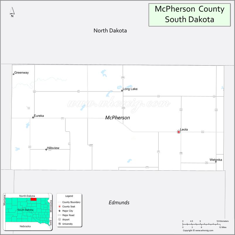
Map of McPherson County, South Dakota
About McCook County Map, South Dakota: The map showing the county boundary, county seat, major cities, highways, water bodies and neighbouring counties.
More South Dakota Maps & Info
About McPherson County, South Dakota
McPherson County is a county located in the U.S. state of South Dakota. It's county seat is Leola. As per 2020 census, the population of McPherson County is 2420 people and population density is square miles. According to the United States Census Bureau, the county has a total area of 1,137 sq mi (2,945 km2). McPherson County was established on 1873.
McPherson County Facts
| Continent | North America |
| Country | United States |
| State | South Dakota |
| County Seat | Leola |
| Largest City/Town | Eureka |
| Established | 1873 |
| Total Area | 1,152 sq mi (2,984 sq km) |
| Land Area | 1,132 sq mi (2,932 sq km) |
| Water Area | 20 sq mi (52 sq km) |
| Population | 2,411 (Census 2020) |
| Population Density | 2.1 people per sq mi |
| Time Zone | Central Time Zone (CT) |
| Major Highways | US 12, SD 10, SD 45 |
| Major Rivers | Elm River watershed nearby |
| Neighboring Counties | Campbell County, Walworth County, Edmunds County, Brown County, Dickey County (ND) |
| Famous For | German-Russian heritage, agriculture, prairie lakes, hunting and fishing |
| Top Attractions | Eureka attractions, fishing lakes, hunting areas, prairie recreation destinations |
| Official Website | Official Website |
About McPherson County, South Dakota
McPherson County is located in north-central South Dakota in the United States and was established in 1873. The county seat is Leola, while Eureka is the largest town. The county is known for its German-Russian cultural heritage, agriculture, prairie lakes, and outdoor recreation opportunities.
Cities and Towns in McPherson County, South Dakota
| City/Town | Population (Census 2020) | Latitude & Longitude |
|---|---|---|
| Leola (county seat) | 434 | 45.7225°N, 98.9409°W |
| Eureka | 855 | 45.7694°N, 99.6248°W |
| Long Lake | 27 | 45.8544°N, 99.2126°W |
| Hillsview | 6 | 45.7353°N, 99.4587°W |
| Wetonka nearby | 8 | 45.6736°N, 98.7292°W |
| Frederick nearby | 199 | 45.8347°N, 98.5018°W |
Golf Courses in McPherson County, South Dakota
| Golf Course | Location | Latitude & Longitude |
|---|---|---|
| Eureka Community Golf Course | Eureka | 45.7731°N, 99.6314°W |
| Lee Park Golf Course nearby | Aberdeen | 45.4860°N, 98.4737°W |
| Valley View Country Club nearby | Aberdeen | 45.4686°N, 98.4654°W |
| Mobridge Country Club nearby | Mobridge | 45.5386°N, 100.4234°W |
Roads and Highways in McPherson County, South Dakota
Major highways connect the county to northern South Dakota communities and prairie recreation areas.
- US Highway 12 - major east-west route across northern South Dakota
- South Dakota Highway 10 - regional roadway linking rural communities
- South Dakota Highway 45 - north-south route through agricultural areas
What are Neighboring Counties of McPherson County
- Campbell County (west)
- Walworth County (southwest)
- Edmunds County (south)
- Brown County (east)
- Dickey County, North Dakota (north)
What are the Top Attractions in McPherson County, South Dakota
The county offers a mix of prairie recreation, cultural heritage, and outdoor activities.
- Eureka attractions - local restaurants, shops, museums, and community events
- Fishing lakes and ponds - walleye, perch, and northern pike recreation opportunities
- Hunting areas - pheasant, deer, and waterfowl hunting destinations
- Prairie recreation destinations - scenic countryside exploration and wildlife viewing
- Eureka Community Golf Course - golf and family recreation facility
- German-Russian heritage sites - cultural history and local traditions
- Birdwatching and wetland habitats - migratory bird and prairie wildlife viewing
- Camping and RV parks nearby - family-friendly outdoor recreation destinations
- Prairie scenic drives - rolling farmland and Great Plains landscapes
- Photography and sunset viewing across prairie lakes - scenic outdoor experiences
- Regional fairs and rodeos - celebrating agriculture and local traditions
- Winter snowmobiling and outdoor recreation - seasonal prairie adventures
- Historic churches and pioneer landmarks - reflecting settlement history
- Nearby Aberdeen attractions - museums, shopping, golf, and entertainment venues
What is the Distance from McPherson County to Nearby Cities
The following distances are measured by road (driving).
- Eureka to Aberdeen (Brown County), South Dakota - 67 mi (108 km)
- Eureka to Mobridge (Walworth County), South Dakota - 59 mi (95 km)
- Eureka to Bismarck (Burleigh County), North Dakota - 136 mi (219 km)
- Eureka to Fargo (Cass County), North Dakota - 190 mi (306 km)
- Eureka to Pierre (Hughes County), South Dakota - 164 mi (264 km)
- Eureka to Watertown (Codington County), South Dakota - 164 mi (264 km)
- Eureka to Sioux Falls (Minnehaha County), South Dakota - 278 mi (447 km)
- Eureka to Minneapolis (Hennepin County), Minnesota - 351 mi (565 km)
- Eureka to Billings (Yellowstone County), Montana - 451 mi (726 km)
- Eureka to Omaha (Douglas County), Nebraska - 449 mi (723 km)
- Eureka to Rapid City (Pennington County), South Dakota - 332 mi (534 km)
- Eureka to Denver (Denver County), Colorado - 620 mi (998 km)
FAQs about McPherson County
McPherson County is located in north-central South Dakota near the North Dakota border.
McPherson County had a population of 2,411 according to the 2020 United States Census.
McPherson County is known for German-Russian heritage, agriculture, prairie lakes, hunting, and fishing.
The major highways include US Highway 12, South Dakota Highway 10, and South Dakota Highway 45.
Yes, McPherson County has golf facilities including Eureka Community Golf Course and nearby regional golf clubs.
References
- QuickFacts - U.S. Census Bureau
- United States Census Bureau
- United States Geological Survey (USGS)
- National Geodetic Survey
- Official Website
- Aurora County Map
- Beadle County Map
- Bennett County Map
- Bon Homme County Map
- Brookings County Map
- Brown County Map
- Brule County Map
- Buffalo County Map
- Butte County Map
- Campbell County Map
- Charles Mix County Map
- Clark County Map
- Clay County Map
- Codington County Map
- Corson County Map
- Custer County Map
- Davison County Map
- Day County Map
- Deuel County Map
- Dewey County Map
- Douglas County Map
- Edmunds County Map
- Fall River County Map
- Faulk County Map
- Grant County Map
- Gregory County Map
- Haakon County Map
- Hamlin County Map
- Hand County Map
- Hanson County Map
- Harding County Map
- Hughes County Map
- Hutchinson County Map
- Hyde County Map
- Jackson County Map
- Jerauld County Map
- Jones County Map
- Kingsbury County Map
- Lake County Map
- Lawrence County Map
- Lincoln County Map
- Lyman County Map
- McCook County Map
- McPherson County Map
- Marshall County Map
- Meade County Map
- Mellette County Map
- Miner County Map
- Minnehaha County Map
- Moody County Map
- Oglala Lakota County Map
- Pennington County Map
- Perkins County Map
- Potter County Map
- Roberts County Map
- Sanborn County Map
- Spink County Map
- Stanley County Map
- Sully County Map
- Todd County Map
- Tripp County Map
- Turner County Map
- Union County Map
- Walworth County Map
- Yankton County Map
- Ziebach County Map
- Alabama Counties
- Alaska boroughs
- Arizona Counties
- Arkansas Counties
- California County Map
- Colorado Counties
- Connecticut Counties
- Delaware Counties
- Florida County Map
- Georgia County Map
- Hawaii Counties
- Idaho Counties
- Illinois Counties
- Indiana Counties
- Iowa Counties
- Kansas Counties
- Kentucky Counties
- Louisiana Counties
- Maine Counties
- Maryland Counties
- Massachusetts Counties
- Michigan County Map
- Minnesota Counties
- Mississippi Counties
- Missouri Counties
- Montana Counties
- Nebraska Counties
- Nevada Counties
- New York Counties
- New Hampshire Counties
- New Jersey Counties
- New Mexico Counties
- North Carolina Counties
- North Dakota Counties
- Ohio County Map
- Oklahoma Counties
- Oregon Counties
- Pennsylvania Counties
- Rhode Island Counties
- South Carolina Counties
- South Dakota Counties
- Map of Tennessee
- Texas County Map
- Utah Counties
- Vermont Counties
- Virginia Counties
- Washington Counties
- West Virginia Counties
- Wisconsin Counties
- Wyoming Counties