Written and Fact-checked by Whereig Editors, Reviewed by Mukesh Kumar| Last Updated On: May 11, 2026
Map of Fall River County - Fall River County is a county located in the U.S. state of South Dakota. Fall River County Map showing cities, highways, important places and water bodies. Get Where is Fall River County located in the map, major cities in Fall River county, population, areas, and places of interest.
Map of Fall River County, South Dakota
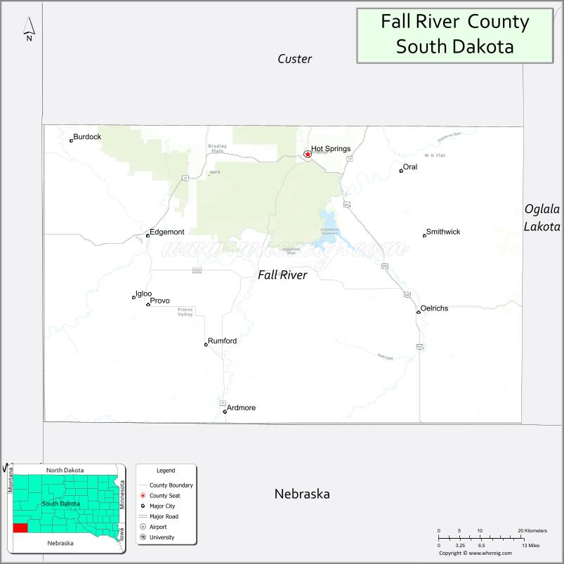
About Fall River County Map, South Dakota: The map showing the county boundary, county seat, major cities, highways, water bodies and neighbouring counties.
More South Dakota Maps & Info
About Fall River County, South Dakota
Fall River County is a county located in the U.S. state of South Dakota. It's county seat is Hot Springs. As per 2020 census, the population of Fall River County is 7202 people and population density is square miles. According to the United States Census Bureau, the county has a total area of 1,740 sq mi (4,507 km2). Fall River County was established on 1883.
Fall River County Facts
| Continent | North America |
| Country | United States |
| State | South Dakota |
| County Seat | Hot Springs |
| Largest City/Town | Hot Springs |
| Established | 1883 |
| Total Area | 1,740 sq mi (4,507 sq km) |
| Land Area | 1,739 sq mi (4,504 sq km) |
| Water Area | 1 sq mi (3 sq km) |
| Population | 6,973 (Census 2020) |
| Population Density | 4.0 people per sq mi |
| Time Zone | Mountain Time Zone (MT) |
| Major Highways | US 18, US 385, SD 79 |
| Major Rivers | Cheyenne River nearby, Fall River |
| Neighboring Counties | Custer County, Oglala Lakota County, Pennington County, Dawes County (NE), Niobrara County (WY) |
| Famous For | Hot Springs, Mammoth Site, Black Hills, natural warm springs |
| Top Attractions | Mammoth Site, Evans Plunge, Wind Cave National Park nearby, Hot Springs sandstone architecture |
| Official Website | Official Website |
About Fall River County, South Dakota
Fall River County is located in southwestern South Dakota in the United States and was established in 1883. The county seat and largest city is Hot Springs. The county is known for natural warm springs, Black Hills scenery, prehistoric fossils, tourism attractions, and outdoor recreation opportunities.
Cities and Towns in Fall River County, South Dakota
| City/Town | Population (Census 2020) | Latitude & Longitude |
|---|---|---|
| Hot Springs (county seat) | 3,395 | 43.4316°N, 103.4744°W |
| Edgemont | 748 | 43.3014°N, 103.8255°W |
| Oelrichs | 126 | 43.1775°N, 103.2310°W |
| Oral | 66 | 43.1836°N, 103.1876°W |
| Buffalo Gap nearby | 126 | 43.4908°N, 103.3157°W |
| Provo | 11 | 43.0692°N, 103.8735°W |
Golf Courses in Fall River County, South Dakota
| Golf Course | Location | Latitude & Longitude |
|---|---|---|
| Southern Hills Golf Course | Hot Springs | 43.4329°N, 103.4832°W |
| Rocky Knolls Golf Course nearby | Custer | 43.7605°N, 103.6052°W |
| Hart Ranch Golf Club nearby | Rapid City | 43.9778°N, 103.3112°W |
| Prairie Hills Golf Course nearby | Sundance, Wyoming | 44.4078°N, 104.3724°W |
Roads and Highways in Fall River County, South Dakota
Major highways connect the county to the Black Hills, Nebraska, and Wyoming regions.
- US Highway 18 - major east-west route across southern South Dakota
- US Highway 385 - scenic north-south route through the Black Hills region
- South Dakota Highway 79 - highway linking local communities and recreation areas
What are Neighboring Counties of Fall River County
- Custer County (north)
- Pennington County (northwest)
- Oglala Lakota County (east)
- Dawes County, Nebraska (south)
- Niobrara County, Wyoming (southwest)
What are the Top Attractions in Fall River County, South Dakota
The county offers a mix of Black Hills scenery, fossil discoveries, and outdoor recreation.
- Mammoth Site - world-famous active paleontological dig site featuring Ice Age mammoth fossils
- Evans Plunge Mineral Springs - historic indoor warm-water swimming attraction
- Wind Cave National Park nearby - cave tours, hiking, and wildlife viewing opportunities
- Hot Springs sandstone architecture - historic downtown buildings made from local sandstone
- Black Hills scenic drives - mountain views and outdoor recreation routes
- Southern Hills Golf Course - scenic golf destination in Hot Springs
- Moccasin Springs Natural Mineral Spa - relaxing geothermal pools and wellness attraction
- Angostura Reservoir nearby - boating, fishing, swimming, and camping destination
- Mickelson Trail nearby - biking and hiking trail through the Black Hills
- Wildlife viewing areas - bison, elk, deer, and prairie wildlife habitats
- Edgemont railroad heritage sites - historic rail history and scenic surroundings
- Fishing and hunting areas - outdoor recreation throughout the county
- Fall River hot mineral springs - natural geothermal attractions
- Regional rodeos and festivals - celebrating western heritage and local culture
What is the Distance from Fall River County to Nearby Cities
The following distances are measured by road (driving).
- Hot Springs to Custer (Custer County), South Dakota - 27 mi (43 km)
- Hot Springs to Rapid City (Pennington County), South Dakota - 57 mi (92 km)
- Hot Springs to Chadron (Dawes County), Nebraska - 58 mi (93 km)
- Hot Springs to Casper (Natrona County), Wyoming - 241 mi (388 km)
- Hot Springs to Pierre (Hughes County), South Dakota - 235 mi (378 km)
- Hot Springs to Sioux Falls (Minnehaha County), South Dakota - 383 mi (616 km)
- Hot Springs to Denver (Denver County), Colorado - 351 mi (565 km)
- Hot Springs to Billings (Yellowstone County), Montana - 351 mi (565 km)
- Hot Springs to Omaha (Douglas County), Nebraska - 403 mi (649 km)
- Hot Springs to Bismarck (Burleigh County), North Dakota - 394 mi (634 km)
- Hot Springs to Minneapolis (Hennepin County), Minnesota - 662 mi (1,065 km)
- Hot Springs to Kansas City (Jackson County), Missouri - 607 mi (977 km)
FAQs about Fall River County
Fall River County is located in southwestern South Dakota in the southern Black Hills region.
Fall River County had a population of 6,973 according to the 2020 United States Census.
Fall River County is known for Hot Springs, the Mammoth Site, natural mineral springs, and Black Hills tourism.
The major highways include US Highway 18, US Highway 385, and South Dakota Highway 79.
Yes, Fall River County has golf facilities including Southern Hills Golf Course and nearby Black Hills golf clubs.
References
- QuickFacts - U.S. Census Bureau
- United States Census Bureau
- United States Geological Survey (USGS)
- National Geodetic Survey
- Official Website
- Aurora County Map
- Beadle County Map
- Bennett County Map
- Bon Homme County Map
- Brookings County Map
- Brown County Map
- Brule County Map
- Buffalo County Map
- Butte County Map
- Campbell County Map
- Charles Mix County Map
- Clark County Map
- Clay County Map
- Codington County Map
- Corson County Map
- Custer County Map
- Davison County Map
- Day County Map
- Deuel County Map
- Dewey County Map
- Douglas County Map
- Edmunds County Map
- Fall River County Map
- Faulk County Map
- Grant County Map
- Gregory County Map
- Haakon County Map
- Hamlin County Map
- Hand County Map
- Hanson County Map
- Harding County Map
- Hughes County Map
- Hutchinson County Map
- Hyde County Map
- Jackson County Map
- Jerauld County Map
- Jones County Map
- Kingsbury County Map
- Lake County Map
- Lawrence County Map
- Lincoln County Map
- Lyman County Map
- McCook County Map
- McPherson County Map
- Marshall County Map
- Meade County Map
- Mellette County Map
- Miner County Map
- Minnehaha County Map
- Moody County Map
- Oglala Lakota County Map
- Pennington County Map
- Perkins County Map
- Potter County Map
- Roberts County Map
- Sanborn County Map
- Spink County Map
- Stanley County Map
- Sully County Map
- Todd County Map
- Tripp County Map
- Turner County Map
- Union County Map
- Walworth County Map
- Yankton County Map
- Ziebach County Map
- Alabama Counties
- Alaska boroughs
- Arizona Counties
- Arkansas Counties
- California County Map
- Colorado Counties
- Connecticut Counties
- Delaware Counties
- Florida County Map
- Georgia County Map
- Hawaii Counties
- Idaho Counties
- Illinois Counties
- Indiana Counties
- Iowa Counties
- Kansas Counties
- Kentucky Counties
- Louisiana Counties
- Maine Counties
- Maryland Counties
- Massachusetts Counties
- Michigan County Map
- Minnesota Counties
- Mississippi Counties
- Missouri Counties
- Montana Counties
- Nebraska Counties
- Nevada Counties
- New York Counties
- New Hampshire Counties
- New Jersey Counties
- New Mexico Counties
- North Carolina Counties
- North Dakota Counties
- Ohio County Map
- Oklahoma Counties
- Oregon Counties
- Pennsylvania Counties
- Rhode Island Counties
- South Carolina Counties
- South Dakota Counties
- Map of Tennessee
- Texas County Map
- Utah Counties
- Vermont Counties
- Virginia Counties
- Washington Counties
- West Virginia Counties
- Wisconsin Counties
- Wyoming Counties