Written and Fact-checked by Whereig Editors, Reviewed by Mukesh Kumar| Last Updated On: May 11, 2026
Map of Harding County - Harding County is a county located in the U.S. state of South Dakota. Harding County Map showing cities, highways, important places and water bodies. Get Where is Harding County located in the map, major cities in Harding county, population, areas, and places of interest.
Map of Harding County, South Dakota
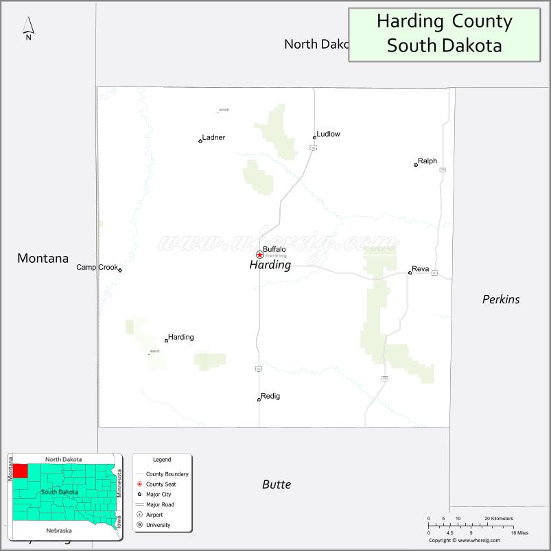
About Harding County Map, South Dakota: The map showing the county boundary, county seat, major cities, highways, water bodies and neighbouring counties.
More South Dakota Maps & Info
About Harding County, South Dakota
Harding County is a county located in the U.S. state of South Dakota. It's county seat is Buffalo. As per 2020 census, the population of Harding County is 1327 people and population density is square miles. According to the United States Census Bureau, the county has a total area of 2,671 sq mi (6,918 km2). Harding County was established on 1909.
Harding County Facts
| Continent | North America |
| Country | United States |
| State | South Dakota |
| County Seat | Buffalo |
| Largest City/Town | Buffalo |
| Established | 1881 |
| Total Area | 2,678 sq mi (6,936 sq km) |
| Land Area | 2,671 sq mi (6,918 sq km) |
| Water Area | 7 sq mi (18 sq km) |
| Population | 1,311 (Census 2020) |
| Population Density | 0.5 people per sq mi |
| Time Zone | Mountain Time Zone (MT) |
| Major Highways | US 85, SD 20, SD 79 |
| Major Rivers | Little Missouri River nearby |
| Neighboring Counties | Perkins County, Butte County, Carter County (MT), Fallon County (MT), Bowman County (ND), Slope County (ND) |
| Famous For | Ranching, open prairie landscapes, western heritage, hunting and fossil sites |
| Top Attractions | Buffalo attractions, Slim Buttes, hunting areas, western ranch landscapes |
| Official Website | Official Website |
About Harding County, South Dakota
Harding County is located in the far northwestern corner of South Dakota in the United States and was established in 1881. The county seat and largest city is Buffalo. The county is known for ranching, western heritage, dramatic prairie landscapes, fossil discoveries, and outdoor recreation.
Cities and Towns in Harding County, South Dakota
| City/Town | Population (Census 2020) | Latitude & Longitude |
|---|---|---|
| Buffalo (county seat) | 346 | 45.5855°N, 103.5460°W |
| Ludlow | 10 | 45.7980°N, 103.3758°W |
| Camp Crook | 63 | 45.5530°N, 103.9547°W |
| Reva | 12 | 45.5239°N, 103.1501°W |
| Ralph | 8 | 45.8270°N, 103.2426°W |
| Table Mountain nearby | 5 | 45.6697°N, 103.6282°W |
Golf Courses in Harding County, South Dakota
| Golf Course | Location | Latitude & Longitude |
|---|---|---|
| Buffalo Hills Golf Course | Buffalo | 45.5891°N, 103.5524°W |
| Spearfish Canyon Country Club nearby | Spearfish | 44.4902°N, 103.8715°W |
| Belle Fourche Country Club nearby | Belle Fourche | 44.6713°N, 103.8528°W |
| Prairie Hills Golf Course nearby | Sundance, Wyoming | 44.4078°N, 104.3724°W |
Roads and Highways in Harding County, South Dakota
Major highways connect the county to western South Dakota, North Dakota, Montana, and Wyoming ranching regions.
- US Highway 85 - major north-south highway through western South Dakota
- South Dakota Highway 20 - scenic east-west route across northern South Dakota
- South Dakota Highway 79 - roadway linking ranching communities and prairie areas
What are Neighboring Counties of Harding County
- Perkins County (south)
- Butte County (southwest)
- Carter County, Montana (west)
- Fallon County, Montana (northwest)
- Bowman County, North Dakota (north)
- Slope County, North Dakota (northeast)
What are the Top Attractions in Harding County, South Dakota
The county offers a mix of western heritage, prairie scenery, and outdoor adventure opportunities.
- Buffalo attractions - local museums, restaurants, and western-themed community events
- Slim Buttes - dramatic sandstone formations and scenic prairie landscapes
- Hunting areas - deer, antelope, and prairie game hunting opportunities
- Western ranch landscapes - classic open-range scenery and cattle ranches
- Fossil discovery sites - prehistoric geological formations and paleontology interests
- Prairie scenic drives - panoramic views of grasslands and buttes
- Camping and RV destinations - remote outdoor recreation experiences
- Birdwatching and wildlife viewing - prairie ecosystems and migratory species
- Buffalo Hills Golf Course - recreation and golf facility
- Historic ranching communities - reflecting Old West and cowboy heritage
- Photography and sunset viewing across prairie landscapes - scenic western experiences
- Regional rodeos and county fairs - celebrating ranching traditions and local culture
- Horseback riding and trail exploration - outdoor western recreation
- Winter recreation and remote outdoor adventures - seasonal prairie activities
What is the Distance from Harding County to Nearby Cities
The following distances are measured by road (driving).
- Buffalo to Belle Fourche (Butte County), South Dakota - 88 mi (142 km)
- Buffalo to Spearfish (Lawrence County), South Dakota - 109 mi (175 km)
- Buffalo to Rapid City (Pennington County), South Dakota - 169 mi (272 km)
- Buffalo to Bismarck (Burleigh County), North Dakota - 209 mi (336 km)
- Buffalo to Billings (Yellowstone County), Montana - 265 mi (426 km)
- Buffalo to Casper (Natrona County), Wyoming - 253 mi (407 km)
- Buffalo to Pierre (Hughes County), South Dakota - 251 mi (404 km)
- Buffalo to Sioux Falls (Minnehaha County), South Dakota - 445 mi (716 km)
- Buffalo to Denver (Denver County), Colorado - 426 mi (686 km)
- Buffalo to Fargo (Cass County), North Dakota - 414 mi (666 km)
- Buffalo to Minneapolis (Hennepin County), Minnesota - 652 mi (1,049 km)
- Buffalo to Omaha (Douglas County), Nebraska - 578 mi (930 km)
FAQs about Harding County
Harding County is located in the far northwestern corner of South Dakota near Montana and North Dakota.
Harding County had a population of 1,311 according to the 2020 United States Census.
Harding County is known for ranching, prairie landscapes, western heritage, hunting, and fossil sites.
The major highways include US Highway 85, South Dakota Highway 20, and South Dakota Highway 79.
Yes, Harding County has golf facilities including Buffalo Hills Golf Course and nearby regional golf clubs.
References
- QuickFacts - U.S. Census Bureau
- United States Census Bureau
- United States Geological Survey (USGS)
- National Geodetic Survey
- Official Website
- Aurora County Map
- Beadle County Map
- Bennett County Map
- Bon Homme County Map
- Brookings County Map
- Brown County Map
- Brule County Map
- Buffalo County Map
- Butte County Map
- Campbell County Map
- Charles Mix County Map
- Clark County Map
- Clay County Map
- Codington County Map
- Corson County Map
- Custer County Map
- Davison County Map
- Day County Map
- Deuel County Map
- Dewey County Map
- Douglas County Map
- Edmunds County Map
- Fall River County Map
- Faulk County Map
- Grant County Map
- Gregory County Map
- Haakon County Map
- Hamlin County Map
- Hand County Map
- Hanson County Map
- Harding County Map
- Hughes County Map
- Hutchinson County Map
- Hyde County Map
- Jackson County Map
- Jerauld County Map
- Jones County Map
- Kingsbury County Map
- Lake County Map
- Lawrence County Map
- Lincoln County Map
- Lyman County Map
- McCook County Map
- McPherson County Map
- Marshall County Map
- Meade County Map
- Mellette County Map
- Miner County Map
- Minnehaha County Map
- Moody County Map
- Oglala Lakota County Map
- Pennington County Map
- Perkins County Map
- Potter County Map
- Roberts County Map
- Sanborn County Map
- Spink County Map
- Stanley County Map
- Sully County Map
- Todd County Map
- Tripp County Map
- Turner County Map
- Union County Map
- Walworth County Map
- Yankton County Map
- Ziebach County Map
- Alabama Counties
- Alaska boroughs
- Arizona Counties
- Arkansas Counties
- California County Map
- Colorado Counties
- Connecticut Counties
- Delaware Counties
- Florida County Map
- Georgia County Map
- Hawaii Counties
- Idaho Counties
- Illinois Counties
- Indiana Counties
- Iowa Counties
- Kansas Counties
- Kentucky Counties
- Louisiana Counties
- Maine Counties
- Maryland Counties
- Massachusetts Counties
- Michigan County Map
- Minnesota Counties
- Mississippi Counties
- Missouri Counties
- Montana Counties
- Nebraska Counties
- Nevada Counties
- New York Counties
- New Hampshire Counties
- New Jersey Counties
- New Mexico Counties
- North Carolina Counties
- North Dakota Counties
- Ohio County Map
- Oklahoma Counties
- Oregon Counties
- Pennsylvania Counties
- Rhode Island Counties
- South Carolina Counties
- South Dakota Counties
- Map of Tennessee
- Texas County Map
- Utah Counties
- Vermont Counties
- Virginia Counties
- Washington Counties
- West Virginia Counties
- Wisconsin Counties
- Wyoming Counties