Written and Fact-checked by Whereig Editors, Reviewed by Mukesh Kumar| Last Updated On: May 11, 2026
Map of Davison County - Davison County is a county located in the U.S. state of South Dakota. Davison County Map showing cities, highways, important places and water bodies. Get Where is Davison County located in the map, major cities in Davison county, population, areas, and places of interest.
Map of Davison County, South Dakota
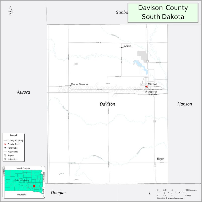
About Davison County Map, South Dakota: The map showing the county boundary, county seat, major cities, highways, water bodies and neighbouring counties.
More South Dakota Maps & Info
About Davison County, South Dakota
Davison County is a county located in the U.S. state of South Dakota. It's county seat is Mitchell. As per 2020 census, the population of Davison County is 19878 people and population density is square miles. According to the United States Census Bureau, the county has a total area of 436 sq mi (1,129 km2). Davison County was established on 1873.
Davison County Facts
| Continent | North America |
| Country | United States |
| State | South Dakota |
| County Seat | Mitchell |
| Largest City/Town | Mitchell |
| Established | 1873 |
| Total Area | 437 sq mi (1,132 sq km) |
| Land Area | 436 sq mi (1,129 sq km) |
| Water Area | 1 sq mi (3 sq km) |
| Population | 19,956 (Census 2020) |
| Population Density | 45.8 people per sq mi |
| Time Zone | Central Time Zone (CT) |
| Major Highways | Interstate 90, US 37, SD 42 |
| Major Rivers | James River nearby |
| Neighboring Counties | Aurora County, Hanson County, Hutchinson County, Jerauld County, Miner County, Sanborn County |
| Famous For | Corn Palace, Mitchell, Dakota Wesleyan University, tourism and agriculture |
| Top Attractions | Corn Palace, Mitchell Prehistoric Indian Village, Dakota Discovery Museum, Lake Mitchell |
| Official Website | Official Website |
About Davison County, South Dakota
Davison County is located in southeastern South Dakota in the United States and was established in 1873. The county seat and largest city is Mitchell. The county is known for tourism, agriculture, educational institutions, and the world-famous Corn Palace attraction.
Cities and Towns in Davison County, South Dakota
| City/Town | Population (Census 2020) | Latitude & Longitude |
|---|---|---|
| Mitchell (county seat) | 15,660 | 43.7094°N, 98.0298°W |
| Ethan | 331 | 43.5361°N, 97.9762°W |
| Mount Vernon | 451 | 43.7100°N, 98.2606°W |
| Alexandria nearby | 615 | 43.6536°N, 97.7823°W |
| Letcher nearby | 159 | 43.8997°N, 98.1448°W |
| Fulton nearby | 87 | 43.8728°N, 97.8187°W |
Golf Courses in Davison County, South Dakota
| Golf Course | Location | Latitude & Longitude |
|---|---|---|
| Lakeview Golf Course | Mitchell | 43.7145°N, 98.0224°W |
| Wild Oak Golf Course | Mitchell | 43.7072°N, 98.0505°W |
| Hitching Post Golf Club nearby | Hitchcock | 44.0116°N, 98.3475°W |
| Scotland Golf Course nearby | Scotland | 43.1481°N, 97.7215°W |
Roads and Highways in Davison County, South Dakota
Major highways connect the county to eastern and western South Dakota through Interstate 90.
- Interstate 90 - major east-west interstate across South Dakota
- US Highway 37 - north-south route linking Mitchell with surrounding communities
- South Dakota Highway 42 - regional route connecting agricultural and rural areas
What are Neighboring Counties of Davison County
- Jerauld County (northwest)
- Aurora County (west)
- Hanson County (east)
- Hutchinson County (southeast)
- Miner County (northeast)
- Sanborn County (north)
What are the Top Attractions in Davison County, South Dakota
The county offers a mix of cultural attractions, recreation, and educational destinations.
- Corn Palace - world-famous attraction decorated annually with corn and grain murals
- Mitchell Prehistoric Indian Village - archaeological site and museum showcasing ancient Native American history
- Dakota Discovery Museum - regional history, art, and cultural exhibits
- Lake Mitchell - boating, fishing, swimming, and lakeside recreation destination
- Dakota Wesleyan University - historic private university with cultural and athletic events
- Mitchell Aquatic Center - family water recreation facility
- Downtown Mitchell - shopping, restaurants, and entertainment venues
- Wild Oak Golf Course - scenic public golf destination
- Hitchcock Park nearby - camping and outdoor recreation area
- Mitchell Main Street and Corn Palace Festival events - annual tourism attractions
- Fishing and hunting areas - pheasant hunting and prairie recreation opportunities
- Historic railroad and pioneer heritage sites - reflecting regional settlement history
- Local wineries and breweries - growing tourism and dining scene
- Mitchell athletic and entertainment venues - concerts, sports, and community events
What is the Distance from Davison County to Nearby Cities
The following distances are measured by road (driving).
- Mitchell to Sioux Falls (Minnehaha County), South Dakota - 72 mi (116 km)
- Mitchell to Chamberlain (Brule County), South Dakota - 73 mi (117 km)
- Mitchell to Huron (Beadle County), South Dakota - 72 mi (116 km)
- Mitchell to Pierre (Hughes County), South Dakota - 152 mi (245 km)
- Mitchell to Sioux City (Woodbury County), Iowa - 131 mi (211 km)
- Mitchell to Omaha (Douglas County), Nebraska - 232 mi (373 km)
- Mitchell to Rapid City (Pennington County), South Dakota - 295 mi (475 km)
- Mitchell to Fargo (Cass County), North Dakota - 305 mi (491 km)
- Mitchell to Minneapolis (Hennepin County), Minnesota - 286 mi (460 km)
- Mitchell to Kansas City (Jackson County), Missouri - 421 mi (678 km)
- Mitchell to Denver (Denver County), Colorado - 534 mi (859 km)
FAQs about Davison County
Davison County is located in southeastern South Dakota along Interstate 90.
Davison County had a population of 19,956 according to the 2020 United States Census.
Davison County is known for the Corn Palace, Mitchell, tourism attractions, and agriculture.
The major highways include Interstate 90, US Highway 37, and South Dakota Highway 42.
Yes, Davison County has golf facilities including Lakeview Golf Course and Wild Oak Golf Course.
References
- QuickFacts - U.S. Census Bureau
- United States Census Bureau
- United States Geological Survey (USGS)
- National Geodetic Survey
- Official Website
- Aurora County Map
- Beadle County Map
- Bennett County Map
- Bon Homme County Map
- Brookings County Map
- Brown County Map
- Brule County Map
- Buffalo County Map
- Butte County Map
- Campbell County Map
- Charles Mix County Map
- Clark County Map
- Clay County Map
- Codington County Map
- Corson County Map
- Custer County Map
- Davison County Map
- Day County Map
- Deuel County Map
- Dewey County Map
- Douglas County Map
- Edmunds County Map
- Fall River County Map
- Faulk County Map
- Grant County Map
- Gregory County Map
- Haakon County Map
- Hamlin County Map
- Hand County Map
- Hanson County Map
- Harding County Map
- Hughes County Map
- Hutchinson County Map
- Hyde County Map
- Jackson County Map
- Jerauld County Map
- Jones County Map
- Kingsbury County Map
- Lake County Map
- Lawrence County Map
- Lincoln County Map
- Lyman County Map
- McCook County Map
- McPherson County Map
- Marshall County Map
- Meade County Map
- Mellette County Map
- Miner County Map
- Minnehaha County Map
- Moody County Map
- Oglala Lakota County Map
- Pennington County Map
- Perkins County Map
- Potter County Map
- Roberts County Map
- Sanborn County Map
- Spink County Map
- Stanley County Map
- Sully County Map
- Todd County Map
- Tripp County Map
- Turner County Map
- Union County Map
- Walworth County Map
- Yankton County Map
- Ziebach County Map
- Alabama Counties
- Alaska boroughs
- Arizona Counties
- Arkansas Counties
- California County Map
- Colorado Counties
- Connecticut Counties
- Delaware Counties
- Florida County Map
- Georgia County Map
- Hawaii Counties
- Idaho Counties
- Illinois Counties
- Indiana Counties
- Iowa Counties
- Kansas Counties
- Kentucky Counties
- Louisiana Counties
- Maine Counties
- Maryland Counties
- Massachusetts Counties
- Michigan County Map
- Minnesota Counties
- Mississippi Counties
- Missouri Counties
- Montana Counties
- Nebraska Counties
- Nevada Counties
- New York Counties
- New Hampshire Counties
- New Jersey Counties
- New Mexico Counties
- North Carolina Counties
- North Dakota Counties
- Ohio County Map
- Oklahoma Counties
- Oregon Counties
- Pennsylvania Counties
- Rhode Island Counties
- South Carolina Counties
- South Dakota Counties
- Map of Tennessee
- Texas County Map
- Utah Counties
- Vermont Counties
- Virginia Counties
- Washington Counties
- West Virginia Counties
- Wisconsin Counties
- Wyoming Counties