Written and Fact-checked by Whereig Editors, Reviewed by Mukesh Kumar| Last Updated On: May 11, 2026
Map of Ziebach County - Ziebach County is a county located in the U.S. state of South Dakota. Ziebach County Map showing cities, highways, important places and water bodies. Get Where is Ziebach County located in the map, major cities in Ziebach county, population, areas, and places of interest.
Map of Ziebach County, South Dakota
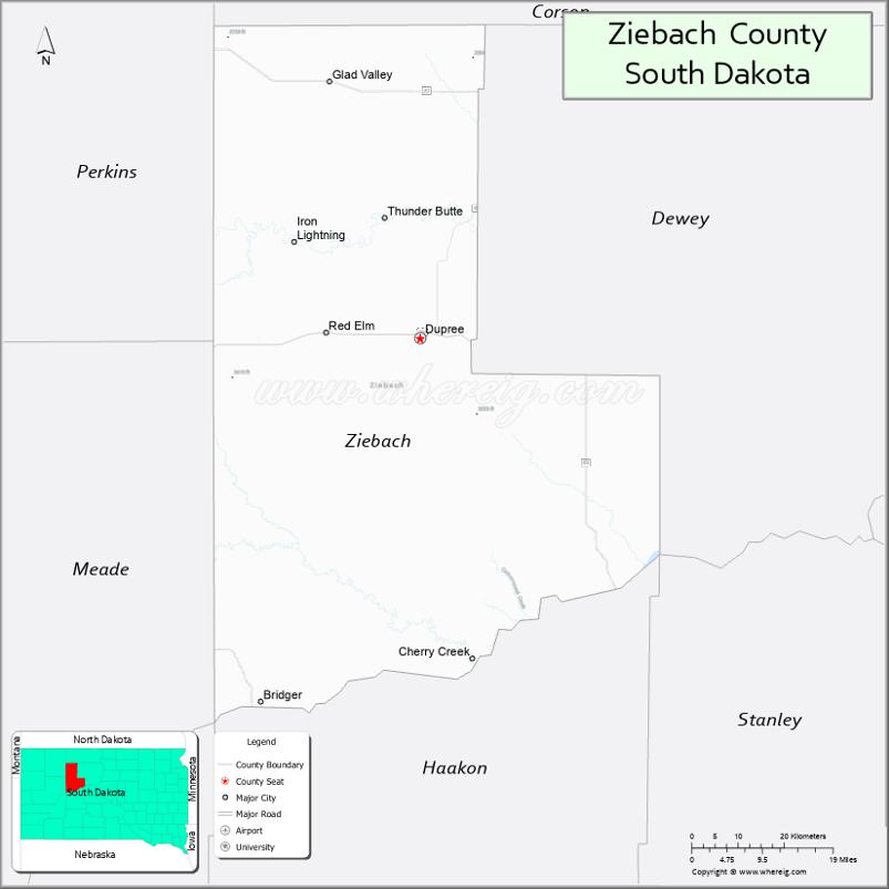
About Ziebach County Map, South Dakota: The map showing the county boundary, county seat, major cities, highways, water bodies and neighbouring counties.
More South Dakota Maps & Info
About Ziebach County, South Dakota
Ziebach County is a county located in the U.S. state of South Dakota. It's county seat is Dupree. As per 2020 census, the population of Ziebach County is 2380 people and population density is square miles. According to the United States Census Bureau, the county has a total area of 1,962 sq mi (5,082 km2). Ziebach County was established on 1911.
Ziebach County Facts
| Continent | North America |
| Country | United States |
| State | South Dakota |
| County Seat | Dupree |
| Largest City/Town | Dupree |
| Established | 1911 |
| Total Area | 1,962 sq mi (5,082 sq km) |
| Land Area | 1,961 sq mi (5,079 sq km) |
| Water Area | 1 sq mi (3 sq km) |
| Population | 2,281 (Census 2020) |
| Population Density | 1.2 people per sq mi |
| Time Zone | Mountain Time Zone (MT) |
| Major Highways | US 212, SD 63, SD 65 |
| Major Rivers | Cheyenne River watershed |
| Neighboring Counties | Dewey County, Corson County, Haakon County, Meade County, Perkins County |
| Famous For | Cheyenne River Reservation, Lakota heritage, ranching, prairie landscapes |
| Top Attractions | Cheyenne River Reservation cultural sites, Dupree attractions, prairie recreation, scenic drives |
| Official Website | Official Website |
About Ziebach County, South Dakota
Ziebach County is located in northwestern South Dakota in the United States and was established in 1911. The county seat and largest town is Dupree. Most of the county lies within the Cheyenne River Indian Reservation, and the area is known for Lakota cultural heritage, ranching, wide-open prairie landscapes, and rural western traditions.
Cities and Towns in Ziebach County, South Dakota
| City/Town | Population (Census 2020) | Latitude & Longitude |
|---|---|---|
| Dupree (county seat) | 494 | 45.0475°N, 101.5990°W |
| Eagle Butte nearby | 1,258 | 45.0144°N, 101.2335°W |
| Cherry Creek nearby | 294 | 44.6072°N, 101.2896°W |
| Timber Lake nearby | 443 | 45.4272°N, 101.0740°W |
| Faith nearby | 397 | 45.0233°N, 102.0374°W |
| Red Scaffold community | Small rural community | 44.9780°N, 101.6710°W |
Golf Courses in Ziebach County, South Dakota
| Golf Course | Location | Latitude & Longitude |
|---|---|---|
| Dupree Golf Recreation Area | Dupree | 45.0518°N, 101.6062°W |
| Timber Lake Country Club nearby | Timber Lake | 45.4310°N, 101.0824°W |
| Meadowbrook Golf Course nearby | Rapid City | 44.0805°N, 103.2417°W |
| Hillsview Golf Course nearby | Pierre | 44.3784°N, 100.3389°W |
Roads and Highways in Ziebach County, South Dakota
Major highways connect the county to western South Dakota ranching communities and reservation areas.
- US Highway 212 - major east-west highway across northern South Dakota
- South Dakota Highway 63 - important north-south regional route
- South Dakota Highway 65 - roadway serving prairie ranching communities
What are Neighboring Counties of Ziebach County
- Corson County (north)
- Dewey County (east)
- Haakon County (south)
- Meade County (southwest)
- Perkins County (west)
What are the Top Attractions in Ziebach County, South Dakota
The county offers a mix of Lakota cultural heritage, prairie scenery, and western outdoor recreation.
- Cheyenne River Reservation cultural attractions - Lakota traditions, arts, and community heritage
- Dupree attractions - local restaurants, shops, and community events
- Prairie scenic drives - rolling ranchlands and Great Plains landscapes
- Hunting and outdoor recreation areas - deer, pheasant, and prairie wildlife recreation
- Cheyenne River watershed landscapes - scenic prairie and river valley views
- Powwows and cultural festivals - celebrating Lakota heritage and traditions
- Birdwatching and wildlife habitats - prairie ecosystems and migratory birds
- Camping and RV areas nearby - outdoor recreation and travel opportunities
- Photography and sunset viewing across prairie landscapes - scenic western experiences
- Historic ranching communities - cowboy culture and frontier traditions
- Traditional Native American arts and crafts - regional cultural experiences
- Winter recreation and snowmobiling opportunities - seasonal prairie adventures
- Historic churches and prairie landmarks - reflecting pioneer and tribal history
- Nearby Badlands and western South Dakota attractions - regional tourism destinations
What is the Distance from Ziebach County to Nearby Cities
The following distances are measured by road (driving).
- Dupree to Eagle Butte (Dewey County), South Dakota - 27 mi (43 km)
- Dupree to Pierre (Hughes County), South Dakota - 115 mi (185 km)
- Dupree to Rapid City (Pennington County), South Dakota - 138 mi (222 km)
- Dupree to Bismarck (Burleigh County), North Dakota - 194 mi (312 km)
- Dupree to Aberdeen (Brown County), South Dakota - 238 mi (383 km)
- Dupree to Fargo (Cass County), North Dakota - 320 mi (515 km)
- Dupree to Billings (Yellowstone County), Montana - 303 mi (488 km)
- Dupree to Casper (Natrona County), Wyoming - 320 mi (515 km)
- Dupree to Sioux Falls (Minnehaha County), South Dakota - 353 mi (568 km)
- Dupree to Denver (Denver County), Colorado - 498 mi (801 km)
- Dupree to Minneapolis (Hennepin County), Minnesota - 555 mi (893 km)
- Dupree to Omaha (Douglas County), Nebraska - 523 mi (842 km)
FAQs about Ziebach County
Ziebach County is located in northwestern South Dakota within the Cheyenne River Reservation region.
Ziebach County had a population of 2,281 according to the 2020 United States Census.
Ziebach County is known for Lakota cultural heritage, ranching, prairie landscapes, and the Cheyenne River Reservation.
The major highways include US Highway 212, South Dakota Highway 63, and South Dakota Highway 65.
Popular attractions include Cheyenne River Reservation cultural sites, prairie scenic drives, and outdoor recreation areas.
References
- QuickFacts - U.S. Census Bureau
- United States Census Bureau
- United States Geological Survey (USGS)
- National Geodetic Survey
- Official Website
- Aurora County Map
- Beadle County Map
- Bennett County Map
- Bon Homme County Map
- Brookings County Map
- Brown County Map
- Brule County Map
- Buffalo County Map
- Butte County Map
- Campbell County Map
- Charles Mix County Map
- Clark County Map
- Clay County Map
- Codington County Map
- Corson County Map
- Custer County Map
- Davison County Map
- Day County Map
- Deuel County Map
- Dewey County Map
- Douglas County Map
- Edmunds County Map
- Fall River County Map
- Faulk County Map
- Grant County Map
- Gregory County Map
- Haakon County Map
- Hamlin County Map
- Hand County Map
- Hanson County Map
- Harding County Map
- Hughes County Map
- Hutchinson County Map
- Hyde County Map
- Jackson County Map
- Jerauld County Map
- Jones County Map
- Kingsbury County Map
- Lake County Map
- Lawrence County Map
- Lincoln County Map
- Lyman County Map
- McCook County Map
- McPherson County Map
- Marshall County Map
- Meade County Map
- Mellette County Map
- Miner County Map
- Minnehaha County Map
- Moody County Map
- Oglala Lakota County Map
- Pennington County Map
- Perkins County Map
- Potter County Map
- Roberts County Map
- Sanborn County Map
- Spink County Map
- Stanley County Map
- Sully County Map
- Todd County Map
- Tripp County Map
- Turner County Map
- Union County Map
- Walworth County Map
- Yankton County Map
- Ziebach County Map
- Alabama Counties
- Alaska boroughs
- Arizona Counties
- Arkansas Counties
- California County Map
- Colorado Counties
- Connecticut Counties
- Delaware Counties
- Florida County Map
- Georgia County Map
- Hawaii Counties
- Idaho Counties
- Illinois Counties
- Indiana Counties
- Iowa Counties
- Kansas Counties
- Kentucky Counties
- Louisiana Counties
- Maine Counties
- Maryland Counties
- Massachusetts Counties
- Michigan County Map
- Minnesota Counties
- Mississippi Counties
- Missouri Counties
- Montana Counties
- Nebraska Counties
- Nevada Counties
- New York Counties
- New Hampshire Counties
- New Jersey Counties
- New Mexico Counties
- North Carolina Counties
- North Dakota Counties
- Ohio County Map
- Oklahoma Counties
- Oregon Counties
- Pennsylvania Counties
- Rhode Island Counties
- South Carolina Counties
- South Dakota Counties
- Map of Tennessee
- Texas County Map
- Utah Counties
- Vermont Counties
- Virginia Counties
- Washington Counties
- West Virginia Counties
- Wisconsin Counties
- Wyoming Counties