Written and Fact-checked by Whereig Editors, Reviewed by Mukesh Kumar| Last Updated On: May 11, 2026
Map of Union County - Union County is a county located in the U.S. state of South Dakota. Union County Map showing cities, highways, important places and water bodies. Get Where is Union County located in the map, major cities in Union county, population, areas, and places of interest.
Map of Union County, South Dakota
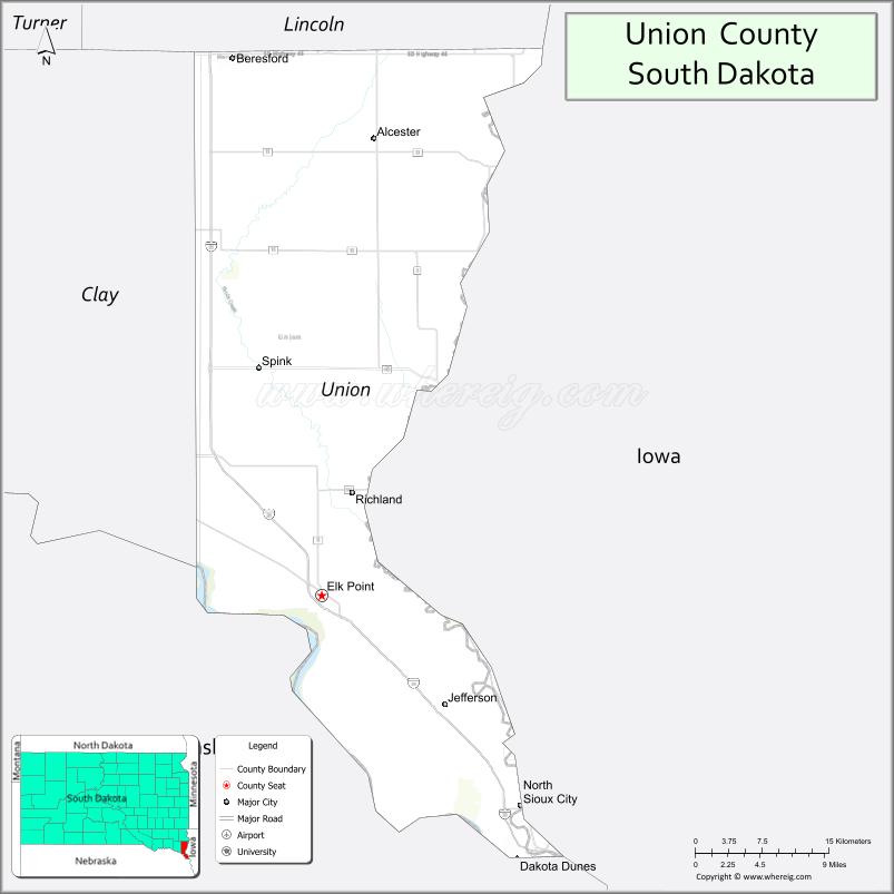
About Union County Map, South Dakota: The map showing the county boundary, county seat, major cities, highways, water bodies and neighbouring counties.
More South Dakota Maps & Info
About Union County, South Dakota
Union County is a county located in the U.S. state of South Dakota. It's county seat is Elk Point. As per 2020 census, the population of Union County is 16872 people and population density is square miles. According to the United States Census Bureau, the county has a total area of 460 sq mi (1,191 km2). Union County was established on 1862.
Union County Facts
| Continent | North America |
| Country | United States |
| State | South Dakota |
| County Seat | Elk Point |
| Largest City/Town | North Sioux City |
| Established | 1862 |
| Total Area | 467 sq mi (1,210 sq km) |
| Land Area | 461 sq mi (1,194 sq km) |
| Water Area | 6 sq mi (16 sq km) |
| Population | 16,811 (Census 2020) |
| Population Density | 36.5 people per sq mi |
| Time Zone | Central Time Zone (CT) |
| Major Highways | Interstate 29, US 18, SD 11 |
| Major Rivers | Missouri River, Big Sioux River |
| Neighboring Counties | Lincoln County, Clay County, Yankton County, Woodbury County (IA), Plymouth County (IA), Dakota County (NE) |
| Famous For | Missouri River recreation, North Sioux City growth, Dakota Dunes, outdoor recreation |
| Top Attractions | Dakota Dunes Country Club, Adams Homestead and Nature Preserve, Missouri River recreation, McCook Lake |
| Official Website | Official Website |
About Union County, South Dakota
Union County is located in southeastern South Dakota in the United States and was established in 1862. The county seat is Elk Point, while North Sioux City is the largest city. The county is known for Missouri River recreation, growing residential communities, golf destinations, and its location within the Sioux City metropolitan area.
Cities and Towns in Union County, South Dakota
| City/Town | Population (Census 2020) | Latitude & Longitude |
|---|---|---|
| North Sioux City | 3,036 | 42.5264°N, 96.4995°W |
| Elk Point (county seat) | 2,149 | 42.6883°N, 96.6859°W |
| Beresford | 2,272 | 43.0808°N, 96.7731°W |
| Alcester | 820 | 43.0203°N, 96.6309°W |
| Jefferson | 623 | 42.5925°N, 96.5595°W |
| Dakota Dunes | 3,020 | 42.4875°N, 96.4850°W |
Golf Courses in Union County, South Dakota
| Golf Course | Location | Latitude & Longitude |
|---|---|---|
| Dakota Dunes Country Club | Dakota Dunes | 42.4898°N, 96.4837°W |
| Two Rivers Golf Club | North Sioux City | 42.5169°N, 96.4971°W |
| Elk Point Country Club | Elk Point | 42.6895°N, 96.6968°W |
| Fox Run Golf Course nearby | Yankton | 42.8875°N, 97.4028°W |
Roads and Highways in Union County, South Dakota
Major highways connect the county to Sioux Falls, Sioux City, Nebraska, Iowa, and regional Missouri River communities.
- Interstate 29 - major north-south interstate highway through eastern South Dakota
- US Highway 18 - important east-west route across southern South Dakota
- South Dakota Highway 11 - regional route connecting southeastern South Dakota communities
What are Neighboring Counties of Union County
- Lincoln County (north)
- Clay County (west)
- Yankton County (northwest)
- Woodbury County, Iowa (east)
- Plymouth County, Iowa (southeast)
- Dakota County, Nebraska (south)
What are the Top Attractions in Union County, South Dakota
The county offers a mix of river recreation, golf resorts, nature preserves, and growing suburban communities.
- Dakota Dunes Country Club - championship golf and resort-style recreation
- Adams Homestead and Nature Preserve - hiking trails, historic buildings, and Missouri River scenery
- Missouri River recreation - boating, fishing, kayaking, and water sports
- McCook Lake recreation areas - fishing, camping, and outdoor activities
- North Sioux City attractions - shopping, restaurants, entertainment, and local events
- Two Rivers Golf Club - scenic golf and recreation destination
- Prairie and river scenic drives - rolling hills and Missouri River Valley landscapes
- Birdwatching and wildlife habitats - river ecosystems and migratory bird viewing
- Camping and RV parks nearby - family-friendly outdoor recreation destinations
- Photography and sunset viewing along the Missouri River - scenic outdoor experiences
- Historic Elk Point attractions - pioneer history and community heritage
- Regional fairs and festivals - celebrating local culture and agriculture
- Fishing and hunting opportunities - outdoor recreation throughout the county
- Nearby Sioux City attractions - museums, shopping centers, and entertainment venues
What is the Distance from Union County to Nearby Cities
The following distances are measured by road (driving).
- Elk Point to Sioux City (Woodbury County), Iowa - 18 mi (29 km)
- Elk Point to Vermillion (Clay County), South Dakota - 25 mi (40 km)
- Elk Point to Yankton (Yankton County), South Dakota - 41 mi (66 km)
- Elk Point to Sioux Falls (Minnehaha County), South Dakota - 58 mi (93 km)
- Elk Point to Omaha (Douglas County), Nebraska - 106 mi (171 km)
- Elk Point to Lincoln (Lancaster County), Nebraska - 162 mi (261 km)
- Elk Point to Des Moines (Polk County), Iowa - 219 mi (352 km)
- Elk Point to Pierre (Hughes County), South Dakota - 267 mi (430 km)
- Elk Point to Fargo (Cass County), North Dakota - 299 mi (481 km)
- Elk Point to Minneapolis (Hennepin County), Minnesota - 280 mi (451 km)
- Elk Point to Rapid City (Pennington County), South Dakota - 414 mi (666 km)
- Elk Point to Denver (Denver County), Colorado - 650 mi (1,046 km)
FAQs about Union County
Union County is located in southeastern South Dakota along the Missouri River near Iowa and Nebraska.
Union County had a population of 16,811 according to the 2020 United States Census.
Union County is known for Missouri River recreation, Dakota Dunes golf communities, and proximity to Sioux City.
The major highways include Interstate 29, US Highway 18, and South Dakota Highway 11.
Popular attractions include Dakota Dunes Country Club, Adams Homestead and Nature Preserve, and Missouri River recreation areas.
References
- QuickFacts - U.S. Census Bureau
- United States Census Bureau
- United States Geological Survey (USGS)
- National Geodetic Survey
- Official Website
- Aurora County Map
- Beadle County Map
- Bennett County Map
- Bon Homme County Map
- Brookings County Map
- Brown County Map
- Brule County Map
- Buffalo County Map
- Butte County Map
- Campbell County Map
- Charles Mix County Map
- Clark County Map
- Clay County Map
- Codington County Map
- Corson County Map
- Custer County Map
- Davison County Map
- Day County Map
- Deuel County Map
- Dewey County Map
- Douglas County Map
- Edmunds County Map
- Fall River County Map
- Faulk County Map
- Grant County Map
- Gregory County Map
- Haakon County Map
- Hamlin County Map
- Hand County Map
- Hanson County Map
- Harding County Map
- Hughes County Map
- Hutchinson County Map
- Hyde County Map
- Jackson County Map
- Jerauld County Map
- Jones County Map
- Kingsbury County Map
- Lake County Map
- Lawrence County Map
- Lincoln County Map
- Lyman County Map
- McCook County Map
- McPherson County Map
- Marshall County Map
- Meade County Map
- Mellette County Map
- Miner County Map
- Minnehaha County Map
- Moody County Map
- Oglala Lakota County Map
- Pennington County Map
- Perkins County Map
- Potter County Map
- Roberts County Map
- Sanborn County Map
- Spink County Map
- Stanley County Map
- Sully County Map
- Todd County Map
- Tripp County Map
- Turner County Map
- Union County Map
- Walworth County Map
- Yankton County Map
- Ziebach County Map
- Alabama Counties
- Alaska boroughs
- Arizona Counties
- Arkansas Counties
- California County Map
- Colorado Counties
- Connecticut Counties
- Delaware Counties
- Florida County Map
- Georgia County Map
- Hawaii Counties
- Idaho Counties
- Illinois Counties
- Indiana Counties
- Iowa Counties
- Kansas Counties
- Kentucky Counties
- Louisiana Counties
- Maine Counties
- Maryland Counties
- Massachusetts Counties
- Michigan County Map
- Minnesota Counties
- Mississippi Counties
- Missouri Counties
- Montana Counties
- Nebraska Counties
- Nevada Counties
- New York Counties
- New Hampshire Counties
- New Jersey Counties
- New Mexico Counties
- North Carolina Counties
- North Dakota Counties
- Ohio County Map
- Oklahoma Counties
- Oregon Counties
- Pennsylvania Counties
- Rhode Island Counties
- South Carolina Counties
- South Dakota Counties
- Map of Tennessee
- Texas County Map
- Utah Counties
- Vermont Counties
- Virginia Counties
- Washington Counties
- West Virginia Counties
- Wisconsin Counties
- Wyoming Counties