Written and Fact-checked by Whereig Editors, Reviewed by Mukesh Kumar| Last Updated On: May 11, 2026
Map of Minnehaha County - Minnehaha County is a county located in the U.S. state of South Dakota. Minnehaha County Map showing cities, highways, important places and water bodies. Get Where is Minnehaha County located in the map, major cities in Minnehaha county, population, areas, and places of interest.
Map of Minnehaha County, South Dakota
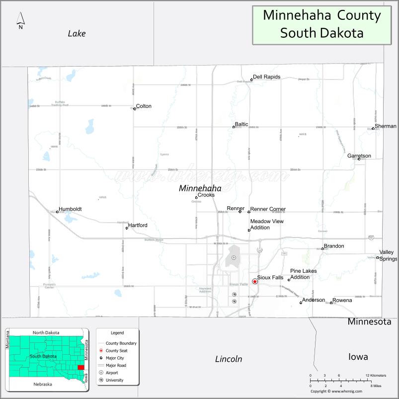
About Minnehaha County Map, South Dakota: The map showing the county boundary, county seat, major cities, highways, water bodies and neighbouring counties.
More South Dakota Maps & Info
About Minnehaha County, South Dakota
Minnehaha County is a county located in the U.S. state of South Dakota. It's county seat is Sioux Falls. As per 2020 census, the population of Minnehaha County is 199685 people and population density is square miles. According to the United States Census Bureau, the county has a total area of 809 sq mi (2,095 km2). Minnehaha County was established on 1862.
Minnehaha County Facts
| Continent | North America |
| Country | United States |
| State | South Dakota |
| County Seat | Sioux Falls |
| Largest City/Town | Sioux Falls |
| Established | 1862 |
| Total Area | 814 sq mi (2,108 sq km) |
| Land Area | 806 sq mi (2,088 sq km) |
| Water Area | 8 sq mi (21 sq km) |
| Population | 197,214 (Census 2020) |
| Population Density | 244.7 people per sq mi |
| Time Zone | Central Time Zone (CT) |
| Major Highways | Interstate 29, Interstate 90, Interstate 229 |
| Major Rivers | Big Sioux River |
| Neighboring Counties | Moody County, Lake County, McCook County, Turner County, Lincoln County, Lyon County (IA), Rock County (MN) |
| Famous For | Sioux Falls, Falls Park, healthcare, finance, and regional commerce |
| Top Attractions | Falls Park, Great Plains Zoo, Butterfly House & Aquarium, Washington Pavilion |
| Official Website | Official Website |
About Minnehaha County, South Dakota
Minnehaha County is located in southeastern South Dakota in the United States and was established in 1862. The county seat and largest city is Sioux Falls, the largest city in South Dakota. The county is known for business growth, healthcare, tourism, higher education, and vibrant cultural and recreational attractions.
Cities and Towns in Minnehaha County, South Dakota
| City/Town | Population (Census 2020) | Latitude & Longitude |
|---|---|---|
| Sioux Falls (county seat) | 192,517 | 43.5460°N, 96.7313°W |
| Brandon | 11,048 | 43.5947°N, 96.5719°W |
| Baltic | 1,246 | 43.7611°N, 96.7406°W |
| Dell Rapids | 3,996 | 43.8247°N, 96.7120°W |
| Garretson | 1,194 | 43.7141°N, 96.5028°W |
| Valley Springs | 922 | 43.5822°N, 96.4745°W |
Golf Courses in Minnehaha County, South Dakota
| Golf Course | Location | Latitude & Longitude |
|---|---|---|
| Elmwood Golf Course | Sioux Falls | 43.5441°N, 96.7417°W |
| Prairie Green Golf Course | Sioux Falls | 43.5008°N, 96.7609°W |
| Bakker Crossing Golf Course | Sioux Falls | 43.4985°N, 96.7594°W |
| Hidden Valley Golf Club | Brandon | 43.6025°N, 96.5822°W |
Roads and Highways in Minnehaha County, South Dakota
Major highways connect the county to regional commerce centers, surrounding states, and major Midwest transportation routes.
- Interstate 29 - major north-south interstate highway through eastern South Dakota
- Interstate 90 - major east-west interstate highway across South Dakota
- Interstate 229 - bypass route serving Sioux Falls metropolitan traffic
What are Neighboring Counties of Minnehaha County
- Moody County (north)
- Lake County (northwest)
- McCook County (west)
- Turner County (southwest)
- Lincoln County (south)
- Lyon County, Iowa (east)
- Rock County, Minnesota (northeast)
What are the Top Attractions in Minnehaha County, South Dakota
The county offers a mix of urban attractions, parks, entertainment venues, and outdoor recreation.
- Falls Park - iconic waterfalls and scenic park in downtown Sioux Falls
- Great Plains Zoo - family-friendly zoo with wildlife exhibits and educational programs
- Butterfly House & Aquarium - tropical butterflies, marine life, and interactive exhibits
- Washington Pavilion - arts, science, and entertainment center with museums and theaters
- Downtown Sioux Falls - restaurants, shopping, breweries, and cultural attractions
- Big Sioux River recreation - walking trails, kayaking, fishing, and scenic parks
- Golf courses and sports complexes - premier recreation facilities throughout the county
- Sertoma Butterfly House - popular educational and tourism destination
- Camping and RV parks nearby - outdoor recreation and travel accommodations
- Levitt at the Falls - outdoor concerts and entertainment events
- Historic Pettigrew Home & Museum - local history and architecture exhibits
- Bike trails and greenways - extensive recreation network across Sioux Falls
- Regional fairs and festivals - celebrating arts, culture, and community traditions
- Shopping malls and entertainment districts - major retail and dining destinations
What is the Distance from Minnehaha County to Nearby Cities
The following distances are measured by road (driving).
- Sioux Falls to Brookings (Brookings County), South Dakota - 57 mi (92 km)
- Sioux Falls to Yankton (Yankton County), South Dakota - 82 mi (132 km)
- Sioux Falls to Sioux City (Woodbury County), Iowa - 85 mi (137 km)
- Sioux Falls to Mitchell (Davison County), South Dakota - 72 mi (116 km)
- Sioux Falls to Omaha (Douglas County), Nebraska - 181 mi (291 km)
- Sioux Falls to Fargo (Cass County), North Dakota - 243 mi (391 km)
- Sioux Falls to Minneapolis (Hennepin County), Minnesota - 237 mi (381 km)
- Sioux Falls to Pierre (Hughes County), South Dakota - 225 mi (362 km)
- Sioux Falls to Rapid City (Pennington County), South Dakota - 348 mi (560 km)
- Sioux Falls to Kansas City (Jackson County), Missouri - 382 mi (615 km)
- Sioux Falls to Bismarck (Burleigh County), North Dakota - 353 mi (568 km)
- Sioux Falls to Denver (Denver County), Colorado - 596 mi (959 km)
FAQs about Minnehaha County
Minnehaha County is located in southeastern South Dakota and includes Sioux Falls, the state's largest city.
Minnehaha County had a population of 197,214 according to the 2020 United States Census.
Minnehaha County is known for Sioux Falls, Falls Park, healthcare, finance, tourism, and regional commerce.
The major highways include Interstate 29, Interstate 90, and Interstate 229.
Yes, Minnehaha County has several golf facilities including Elmwood Golf Course, Prairie Green Golf Course, and Bakker Crossing Golf Course.
References
- QuickFacts - U.S. Census Bureau
- United States Census Bureau
- United States Geological Survey (USGS)
- National Geodetic Survey
- Official Website
- Aurora County Map
- Beadle County Map
- Bennett County Map
- Bon Homme County Map
- Brookings County Map
- Brown County Map
- Brule County Map
- Buffalo County Map
- Butte County Map
- Campbell County Map
- Charles Mix County Map
- Clark County Map
- Clay County Map
- Codington County Map
- Corson County Map
- Custer County Map
- Davison County Map
- Day County Map
- Deuel County Map
- Dewey County Map
- Douglas County Map
- Edmunds County Map
- Fall River County Map
- Faulk County Map
- Grant County Map
- Gregory County Map
- Haakon County Map
- Hamlin County Map
- Hand County Map
- Hanson County Map
- Harding County Map
- Hughes County Map
- Hutchinson County Map
- Hyde County Map
- Jackson County Map
- Jerauld County Map
- Jones County Map
- Kingsbury County Map
- Lake County Map
- Lawrence County Map
- Lincoln County Map
- Lyman County Map
- McCook County Map
- McPherson County Map
- Marshall County Map
- Meade County Map
- Mellette County Map
- Miner County Map
- Minnehaha County Map
- Moody County Map
- Oglala Lakota County Map
- Pennington County Map
- Perkins County Map
- Potter County Map
- Roberts County Map
- Sanborn County Map
- Spink County Map
- Stanley County Map
- Sully County Map
- Todd County Map
- Tripp County Map
- Turner County Map
- Union County Map
- Walworth County Map
- Yankton County Map
- Ziebach County Map
- Alabama Counties
- Alaska boroughs
- Arizona Counties
- Arkansas Counties
- California County Map
- Colorado Counties
- Connecticut Counties
- Delaware Counties
- Florida County Map
- Georgia County Map
- Hawaii Counties
- Idaho Counties
- Illinois Counties
- Indiana Counties
- Iowa Counties
- Kansas Counties
- Kentucky Counties
- Louisiana Counties
- Maine Counties
- Maryland Counties
- Massachusetts Counties
- Michigan County Map
- Minnesota Counties
- Mississippi Counties
- Missouri Counties
- Montana Counties
- Nebraska Counties
- Nevada Counties
- New York Counties
- New Hampshire Counties
- New Jersey Counties
- New Mexico Counties
- North Carolina Counties
- North Dakota Counties
- Ohio County Map
- Oklahoma Counties
- Oregon Counties
- Pennsylvania Counties
- Rhode Island Counties
- South Carolina Counties
- South Dakota Counties
- Map of Tennessee
- Texas County Map
- Utah Counties
- Vermont Counties
- Virginia Counties
- Washington Counties
- West Virginia Counties
- Wisconsin Counties
- Wyoming Counties