Written and Fact-checked by Whereig Editors, Reviewed by Mukesh Kumar| Last Updated On: May 11, 2026
Map of Clay County - Clay County is a county located in the U.S. state of South Dakota. Clay County Map showing cities, highways, important places and water bodies. Get Where is Clay County located in the map, major cities in Clay county, population, areas, and places of interest.
Map of Clay County, South Dakota
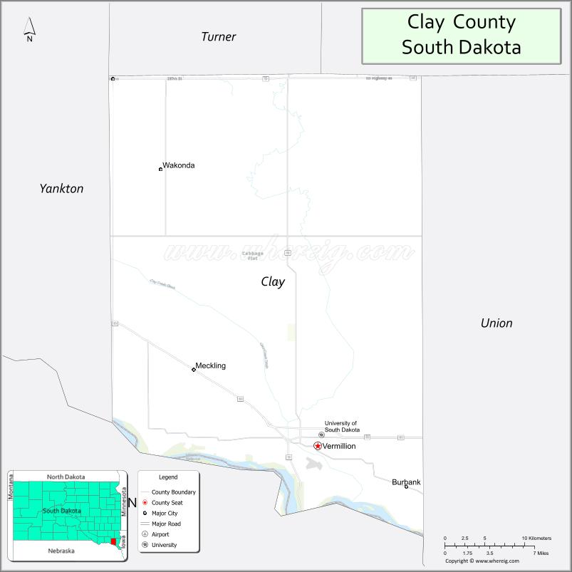
About Clay County Map, South Dakota: The map showing the county boundary, county seat, major cities, highways, water bodies and neighbouring counties.
More South Dakota Maps & Info
About Clay County, South Dakota
Clay County is a county located in the U.S. state of South Dakota. It's county seat is Vermillion. As per 2020 census, the population of Clay County is 15150 people and population density is square miles. According to the United States Census Bureau, the county has a total area of 412 sq mi (1,067 km2). Clay County was established on 1862.
Clay County Facts
| Continent | North America |
| Country | United States |
| State | South Dakota |
| County Seat | Vermillion |
| Largest City/Town | Vermillion |
| Established | 1862 |
| Total Area | 417 sq mi (1,080 sq km) |
| Land Area | 412 sq mi (1,067 sq km) |
| Water Area | 5 sq mi (13 sq km) |
| Population | 14,967 (Census 2020) |
| Population Density | 36.3 people per sq mi |
| Time Zone | Central Time Zone (CT) |
| Major Highways | Interstate 29, US 50, SD 19 |
| Major Rivers | Missouri River |
| Neighboring Counties | Union County, Yankton County, Turner County, Lincoln County (NE), Dixon County (NE) |
| Famous For | University of South Dakota, Vermillion, education, Missouri River Valley |
| Top Attractions | University of South Dakota, National Music Museum, Spirit Mound, Missouri River recreation |
| Official Website | Official Website |
About Clay County, South Dakota
Clay County is located in southeastern South Dakota in the United States and was established in 1862. The county seat and largest city is Vermillion. The county is known for higher education, the University of South Dakota, cultural attractions, and scenic landscapes along the Missouri River Valley.
Cities and Towns in Clay County, South Dakota
| City/Town | Population (Census 2020) | Latitude & Longitude |
|---|---|---|
| Vermillion (county seat) | 11,695 | 42.7794°N, 96.9292°W |
| Wakonda | 321 | 42.9953°N, 97.1070°W |
| Burbank | 85 | 42.7481°N, 96.8367°W |
| Meckling | 73 | 42.8506°N, 97.0945°W |
| Irene nearby | 390 | 43.0803°N, 97.2690°W |
| Elk Point nearby | 2,149 | 42.6869°N, 96.6842°W |
Golf Courses in Clay County, South Dakota
| Golf Course | Location | Latitude & Longitude |
|---|---|---|
| Bluff View Golf Course | Vermillion | 42.7884°N, 96.9397°W |
| The Bluffs Golf Course nearby | Vermillion | 42.7818°N, 96.9475°W |
| Fox Run Golf Course nearby | Yankton | 42.8711°N, 97.4245°W |
| Two Rivers Golf Club nearby | Dakota Dunes | 42.4887°N, 96.4875°W |
Roads and Highways in Clay County, South Dakota
Major highways connect the county to Sioux Falls, Nebraska, and the Missouri River Valley region.
- Interstate 29 - major north-south interstate through eastern South Dakota
- US Highway 50 - regional east-west route serving Vermillion and nearby communities
- South Dakota Highway 19 - north-south route connecting rural communities and agricultural areas
What are Neighboring Counties of Clay County
- Turner County (north)
- Union County (east)
- Yankton County (west)
- Lincoln County, Nebraska (southwest)
- Dixon County, Nebraska (south)
What are the Top Attractions in Clay County, South Dakota
The county offers a mix of educational, cultural, and outdoor attractions.
- University of South Dakota - major public university known for law, medicine, and athletics
- National Music Museum - internationally recognized museum with historic musical instruments
- Spirit Mound Historic Prairie - Lewis and Clark expedition landmark with hiking trails
- Missouri River recreation areas - boating, fishing, kayaking, and camping opportunities
- Vermillion Downtown District - restaurants, shops, art galleries, and entertainment venues
- DakotaDome - sports and event facility at the University of South Dakota
- Bluff View Golf Course - scenic public golf destination
- Clay County Park - recreation and outdoor family activities
- McVicker Plaza and local arts venues - cultural and community gathering spaces
- Nearby Lewis and Clark Lake recreation region - camping and water sports
- Missouri National Recreational River nearby - scenic river landscapes and wildlife viewing
- USD Coyotes athletic events - college sports and entertainment attractions
- Birdwatching and prairie trails - natural landscapes and migratory bird habitats
- Regional wineries and breweries nearby - growing tourism and dining scene
What is the Distance from Clay County to Nearby Cities
The following distances are measured by road (driving).
- Vermillion to Sioux City (Woodbury County), Iowa - 35 mi (56 km)
- Vermillion to Yankton (Yankton County), South Dakota - 33 mi (53 km)
- Vermillion to Sioux Falls (Minnehaha County), South Dakota - 60 mi (97 km)
- Vermillion to Omaha (Douglas County), Nebraska - 153 mi (246 km)
- Vermillion to Lincoln (Lancaster County), Nebraska - 164 mi (264 km)
- Vermillion to Norfolk (Madison County), Nebraska - 77 mi (124 km)
- Vermillion to Pierre (Hughes County), South Dakota - 254 mi (409 km)
- Vermillion to Rapid City (Pennington County), South Dakota - 390 mi (628 km)
- Vermillion to Fargo (Cass County), North Dakota - 343 mi (552 km)
- Vermillion to Minneapolis (Hennepin County), Minnesota - 285 mi (459 km)
- Vermillion to Kansas City (Jackson County), Missouri - 319 mi (513 km)
- Vermillion to Denver (Denver County), Colorado - 534 mi (859 km)
FAQs about Clay County
Clay County is located in southeastern South Dakota along the Missouri River Valley near Nebraska.
Clay County had a population of 14,967 according to the 2020 United States Census.
Clay County is known for the University of South Dakota, Vermillion, cultural attractions, and Missouri River recreation.
The major highways include Interstate 29, US Highway 50, and South Dakota Highway 19.
Yes, Clay County has golf facilities including Bluff View Golf Course and nearby regional golf clubs.
References
- QuickFacts - U.S. Census Bureau
- United States Census Bureau
- United States Geological Survey (USGS)
- National Geodetic Survey
- Official Website
- Aurora County Map
- Beadle County Map
- Bennett County Map
- Bon Homme County Map
- Brookings County Map
- Brown County Map
- Brule County Map
- Buffalo County Map
- Butte County Map
- Campbell County Map
- Charles Mix County Map
- Clark County Map
- Clay County Map
- Codington County Map
- Corson County Map
- Custer County Map
- Davison County Map
- Day County Map
- Deuel County Map
- Dewey County Map
- Douglas County Map
- Edmunds County Map
- Fall River County Map
- Faulk County Map
- Grant County Map
- Gregory County Map
- Haakon County Map
- Hamlin County Map
- Hand County Map
- Hanson County Map
- Harding County Map
- Hughes County Map
- Hutchinson County Map
- Hyde County Map
- Jackson County Map
- Jerauld County Map
- Jones County Map
- Kingsbury County Map
- Lake County Map
- Lawrence County Map
- Lincoln County Map
- Lyman County Map
- McCook County Map
- McPherson County Map
- Marshall County Map
- Meade County Map
- Mellette County Map
- Miner County Map
- Minnehaha County Map
- Moody County Map
- Oglala Lakota County Map
- Pennington County Map
- Perkins County Map
- Potter County Map
- Roberts County Map
- Sanborn County Map
- Spink County Map
- Stanley County Map
- Sully County Map
- Todd County Map
- Tripp County Map
- Turner County Map
- Union County Map
- Walworth County Map
- Yankton County Map
- Ziebach County Map
- Alabama Counties
- Alaska boroughs
- Arizona Counties
- Arkansas Counties
- California County Map
- Colorado Counties
- Connecticut Counties
- Delaware Counties
- Florida County Map
- Georgia County Map
- Hawaii Counties
- Idaho Counties
- Illinois Counties
- Indiana Counties
- Iowa Counties
- Kansas Counties
- Kentucky Counties
- Louisiana Counties
- Maine Counties
- Maryland Counties
- Massachusetts Counties
- Michigan County Map
- Minnesota Counties
- Mississippi Counties
- Missouri Counties
- Montana Counties
- Nebraska Counties
- Nevada Counties
- New York Counties
- New Hampshire Counties
- New Jersey Counties
- New Mexico Counties
- North Carolina Counties
- North Dakota Counties
- Ohio County Map
- Oklahoma Counties
- Oregon Counties
- Pennsylvania Counties
- Rhode Island Counties
- South Carolina Counties
- South Dakota Counties
- Map of Tennessee
- Texas County Map
- Utah Counties
- Vermont Counties
- Virginia Counties
- Washington Counties
- West Virginia Counties
- Wisconsin Counties
- Wyoming Counties