Written and Fact-checked by Whereig Editors, Reviewed by Mukesh Kumar| Last Updated On: May 11, 2026
Map of Haakon County - Haakon County is a county located in the U.S. state of South Dakota. Haakon County Map showing cities, highways, important places and water bodies. Get Where is Haakon County located in the map, major cities in Haakon county, population, areas, and places of interest.
Map of Haakon County, South Dakota
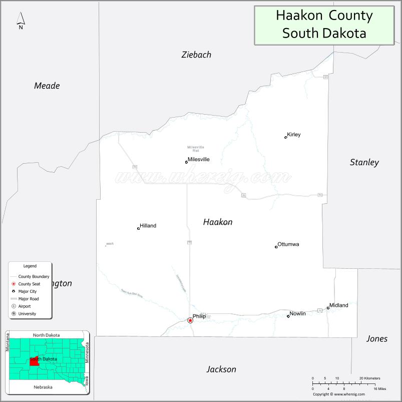
About Haakon County Map, South Dakota: The map showing the county boundary, county seat, major cities, highways, water bodies and neighbouring counties.
More South Dakota Maps & Info
About Haakon County, South Dakota
Haakon County is a county located in the U.S. state of South Dakota. It's county seat is Philip. As per 2020 census, the population of Haakon County is 1835 people and population density is square miles. According to the United States Census Bureau, the county has a total area of 1,813 sq mi (4,696 km2). Haakon County was established on 1914.
Haakon County Facts
| Continent | North America |
| Country | United States |
| State | South Dakota |
| County Seat | Philip |
| Largest City/Town | Philip |
| Established | 1914 |
| Total Area | 1,827 sq mi (4,732 sq km) |
| Land Area | 1,811 sq mi (4,690 sq km) |
| Water Area | 16 sq mi (42 sq km) |
| Population | 1,872 (Census 2020) |
| Population Density | 1.0 people per sq mi |
| Time Zone | Mountain Time Zone (MT) |
| Major Highways | US 14, SD 34, SD 73 |
| Major Rivers | Bad River nearby |
| Neighboring Counties | Meade County, Pennington County, Jackson County, Jones County, Stanley County, Ziebach County |
| Famous For | Ranching, prairie landscapes, Badlands region, hunting and outdoor recreation |
| Top Attractions | Badlands scenery nearby, Prairie Homestead historic site, hunting areas, Philip community attractions |
| Official Website | Official Website |
About Haakon County, South Dakota
Haakon County is located in west-central South Dakota in the United States and was established in 1914. The county seat and largest city is Philip. The county is known for ranching, wide-open prairie landscapes, outdoor recreation, and its proximity to the Badlands region.
Cities and Towns in Haakon County, South Dakota
| City/Town | Population (Census 2020) | Latitude & Longitude |
|---|---|---|
| Philip (county seat) | 779 | 44.0397°N, 101.6660°W |
| Milesville | 12 | 44.3508°N, 101.4968°W |
| Midland nearby | 129 | 44.0789°N, 101.1482°W |
| Kirley | 8 | 43.9950°N, 101.3753°W |
| Ottumwa | 5 | 44.1461°N, 101.7764°W |
| Grindstone | 6 | 44.2687°N, 101.9344°W |
Golf Courses in Haakon County, South Dakota
| Golf Course | Location | Latitude & Longitude |
|---|---|---|
| Lake Waggoner Golf Course | Philip | 44.0428°N, 101.6718°W |
| Meadowbrook Golf Course nearby | Pierre | 44.3689°N, 100.3641°W |
| Hart Ranch Golf Club nearby | Rapid City | 43.9778°N, 103.3112°W |
| Winner Country Club nearby | Winner | 43.3822°N, 99.8618°W |
Roads and Highways in Haakon County, South Dakota
Major highways connect the county to central South Dakota, the Black Hills, and Badlands regions.
- US Highway 14 - major east-west highway across central South Dakota
- South Dakota Highway 34 - route linking ranching communities and prairie regions
- South Dakota Highway 73 - scenic north-south roadway near Badlands areas
What are Neighboring Counties of Haakon County
- Ziebach County (north)
- Meade County (west)
- Pennington County (southwest)
- Jackson County (south)
- Jones County (east)
- Stanley County (northeast)
What are the Top Attractions in Haakon County, South Dakota
The county offers a mix of prairie scenery, ranching culture, and outdoor recreation opportunities.
- Badlands scenery nearby - dramatic rock formations and scenic prairie landscapes
- Prairie Homestead historic site - preserved pioneer sod house and ranching history attraction
- Hunting areas - pheasant, deer, and prairie game hunting opportunities
- Philip community attractions - local shops, museums, restaurants, and seasonal events
- Lake Waggoner recreation area - fishing, camping, and outdoor family activities
- Prairie scenic drives - wide-open Great Plains landscapes and ranchlands
- Birdwatching and wildlife viewing - prairie wildlife habitats and migratory birds
- Camping and RV destinations - outdoor recreation facilities for travelers
- Regional rodeos and county fairs - celebrating ranching and western traditions
- Fishing ponds and prairie reservoirs - outdoor recreation opportunities
- Photography and sunset viewing across prairie landscapes - scenic rural experiences
- Nearby Badlands National Park attractions - hiking and sightseeing opportunities
- Historic ranching heritage sites - local western history and culture
- Winter recreation and snowmobiling - seasonal outdoor activities across prairie areas
What is the Distance from Haakon County to Nearby Cities
The following distances are measured by road (driving).
- Philip to Pierre (Hughes County), South Dakota - 92 mi (148 km)
- Philip to Rapid City (Pennington County), South Dakota - 92 mi (148 km)
- Philip to Wall (Pennington County), South Dakota - 53 mi (85 km)
- Philip to Kadoka (Jackson County), South Dakota - 56 mi (90 km)
- Philip to Sioux Falls (Minnehaha County), South Dakota - 260 mi (418 km)
- Philip to Bismarck (Burleigh County), North Dakota - 246 mi (396 km)
- Philip to Casper (Natrona County), Wyoming - 270 mi (435 km)
- Philip to Billings (Yellowstone County), Montana - 345 mi (555 km)
- Philip to Omaha (Douglas County), Nebraska - 416 mi (669 km)
- Philip to Denver (Denver County), Colorado - 484 mi (779 km)
- Philip to Minneapolis (Hennepin County), Minnesota - 560 mi (901 km)
- Philip to Kansas City (Jackson County), Missouri - 631 mi (1,015 km)
FAQs about Haakon County
Haakon County is located in west-central South Dakota near the Badlands region.
Haakon County had a population of 1,872 according to the 2020 United States Census.
Haakon County is known for ranching, prairie landscapes, hunting, and nearby Badlands scenery.
The major highways include US Highway 14, South Dakota Highway 34, and South Dakota Highway 73.
Yes, Haakon County has golf facilities including Lake Waggoner Golf Course and nearby regional golf courses.
References
- QuickFacts - U.S. Census Bureau
- United States Census Bureau
- United States Geological Survey (USGS)
- National Geodetic Survey
- Official Website
- Aurora County Map
- Beadle County Map
- Bennett County Map
- Bon Homme County Map
- Brookings County Map
- Brown County Map
- Brule County Map
- Buffalo County Map
- Butte County Map
- Campbell County Map
- Charles Mix County Map
- Clark County Map
- Clay County Map
- Codington County Map
- Corson County Map
- Custer County Map
- Davison County Map
- Day County Map
- Deuel County Map
- Dewey County Map
- Douglas County Map
- Edmunds County Map
- Fall River County Map
- Faulk County Map
- Grant County Map
- Gregory County Map
- Haakon County Map
- Hamlin County Map
- Hand County Map
- Hanson County Map
- Harding County Map
- Hughes County Map
- Hutchinson County Map
- Hyde County Map
- Jackson County Map
- Jerauld County Map
- Jones County Map
- Kingsbury County Map
- Lake County Map
- Lawrence County Map
- Lincoln County Map
- Lyman County Map
- McCook County Map
- McPherson County Map
- Marshall County Map
- Meade County Map
- Mellette County Map
- Miner County Map
- Minnehaha County Map
- Moody County Map
- Oglala Lakota County Map
- Pennington County Map
- Perkins County Map
- Potter County Map
- Roberts County Map
- Sanborn County Map
- Spink County Map
- Stanley County Map
- Sully County Map
- Todd County Map
- Tripp County Map
- Turner County Map
- Union County Map
- Walworth County Map
- Yankton County Map
- Ziebach County Map
- Alabama Counties
- Alaska boroughs
- Arizona Counties
- Arkansas Counties
- California County Map
- Colorado Counties
- Connecticut Counties
- Delaware Counties
- Florida County Map
- Georgia County Map
- Hawaii Counties
- Idaho Counties
- Illinois Counties
- Indiana Counties
- Iowa Counties
- Kansas Counties
- Kentucky Counties
- Louisiana Counties
- Maine Counties
- Maryland Counties
- Massachusetts Counties
- Michigan County Map
- Minnesota Counties
- Mississippi Counties
- Missouri Counties
- Montana Counties
- Nebraska Counties
- Nevada Counties
- New York Counties
- New Hampshire Counties
- New Jersey Counties
- New Mexico Counties
- North Carolina Counties
- North Dakota Counties
- Ohio County Map
- Oklahoma Counties
- Oregon Counties
- Pennsylvania Counties
- Rhode Island Counties
- South Carolina Counties
- South Dakota Counties
- Map of Tennessee
- Texas County Map
- Utah Counties
- Vermont Counties
- Virginia Counties
- Washington Counties
- West Virginia Counties
- Wisconsin Counties
- Wyoming Counties