Written and Fact-checked by Whereig Editors, Reviewed by Mukesh Kumar| Last Updated On: May 11, 2026
Map of Oglala Lakota County - Oglala Lakota County is a county located in the U.S. state of South Dakota. Oglala Lakota County Map showing cities, highways, important places and water bodies. Get Where is Oglala Lakota County located in the map, major cities in Oglala Lakota county, population, areas, and places of interest.
Map of Oglala Lakota County, South Dakota
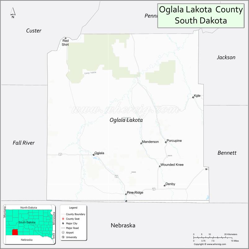
About Oglala Lakota County Map, South Dakota: The map showing the county boundary, county seat, major cities, highways, water bodies and neighbouring counties.
More South Dakota Maps & Info
About Oglala Lakota County, South Dakota
Oglala Lakota County is a county located in the U.S. state of South Dakota. It's county seat is . As per 2020 census, the population of Oglala Lakota County is 13586 people and population density is square miles. According to the United States Census Bureau, the county has a total area of 2,094 sq mi (5,423 km2). Oglala Lakota County was established on 1875.
Oglala Lakota County Facts
| Continent | North America |
| Country | United States |
| State | South Dakota |
| County Seat | Hot Springs (administrative center in Pine Ridge) |
| Largest City/Town | Pine Ridge |
| Established | 1875 |
| Total Area | 2,097 sq mi (5,431 sq km) |
| Land Area | 2,094 sq mi (5,423 sq km) |
| Water Area | 3 sq mi (8 sq km) |
| Population | 13,672 (Census 2020) |
| Population Density | 6.5 people per sq mi |
| Time Zone | Mountain Time Zone (MT) |
| Major Highways | US 18, US 385, SD 40 |
| Major Rivers | White River |
| Neighboring Counties | Jackson County, Bennett County, Fall River County, Custer County, Sheridan County (NE), Dawes County (NE) |
| Famous For | Pine Ridge Reservation, Lakota culture, Badlands scenery, Wounded Knee history |
| Top Attractions | Wounded Knee Memorial, Badlands National Park South Unit, Pine Ridge attractions, Red Cloud Indian School Heritage Center |
| Official Website | Official Website |
About Oglala Lakota County, South Dakota
Oglala Lakota County is located in southwestern South Dakota in the United States and is primarily part of the Pine Ridge Indian Reservation. The county is known for Lakota cultural heritage, significant Native American history, prairie and Badlands landscapes, and important historical sites including Wounded Knee.
Cities and Towns in Oglala Lakota County, South Dakota
| City/Town | Population (Census 2020) | Latitude & Longitude |
|---|---|---|
| Pine Ridge | 3,248 | 43.0250°N, 102.5510°W |
| Kyle | 846 | 43.4253°N, 102.1765°W |
| Porcupine | 1,026 | 43.2397°N, 102.3305°W |
| Manderson | 779 | 43.3136°N, 102.4713°W |
| Wounded Knee | 364 | 43.1411°N, 102.3627°W |
| Oglala | 1,204 | 43.1889°N, 102.7632°W |
Golf Courses in Oglala Lakota County, South Dakota
| Golf Course | Location | Latitude & Longitude |
|---|---|---|
| Southern Hills Golf Course nearby | Hot Springs | 43.4317°N, 103.4748°W |
| Hot Springs Golf Club nearby | Hot Springs | 43.4271°N, 103.4736°W |
| Elks Golf Course nearby | Chadron, Nebraska | 42.8306°N, 103.0090°W |
| Prairie Ridge Golf Course nearby | Box Elder | 44.1042°N, 103.0685°W |
Roads and Highways in Oglala Lakota County, South Dakota
Major highways connect the county to reservation communities, Badlands areas, Nebraska, and western South Dakota.
- US Highway 18 - major east-west highway through southern South Dakota
- US Highway 385 - north-south route linking Black Hills and Nebraska
- South Dakota Highway 40 - regional route connecting reservation communities
What are Neighboring Counties of Oglala Lakota County
- Jackson County (north)
- Bennett County (east)
- Fall River County (west)
- Custer County (northwest)
- Sheridan County, Nebraska (south)
- Dawes County, Nebraska (southwest)
What are the Top Attractions in Oglala Lakota County, South Dakota
The county offers a mix of Lakota cultural heritage, historical landmarks, and prairie recreation.
- Wounded Knee Memorial - historic site commemorating the 1890 massacre and Lakota history
- Badlands National Park South Unit - dramatic landscapes, hiking, and wildlife viewing
- Pine Ridge attractions - cultural centers, local art, and community events
- Red Cloud Indian School Heritage Center - Native American art, history, and cultural exhibits
- Pine Ridge Reservation cultural experiences - Lakota traditions, storytelling, and crafts
- Prairie scenic drives - expansive Great Plains and Badlands landscapes
- White River recreation areas - fishing and outdoor exploration opportunities
- Photography and wildlife viewing - bison, prairie wildlife, and scenic landscapes
- Historic churches and mission sites - reflecting regional cultural heritage
- Camping and outdoor recreation destinations - prairie adventure opportunities
- Local powwows and cultural festivals - celebrating Lakota traditions and community life
- Horseback riding and ranching experiences - western South Dakota culture
- Nearby Black Hills attractions - scenic drives, parks, and outdoor activities
- Traditional Native American arts and crafts markets - regional cultural experiences
What is the Distance from Oglala Lakota County to Nearby Cities
The following distances are measured by road (driving).
- Pine Ridge to Rapid City (Pennington County), South Dakota - 95 mi (153 km)
- Pine Ridge to Hot Springs (Fall River County), South Dakota - 52 mi (84 km)
- Pine Ridge to Chadron (Dawes County), Nebraska - 49 mi (79 km)
- Pine Ridge to Scottsbluff (Scotts Bluff County), Nebraska - 116 mi (187 km)
- Pine Ridge to Pierre (Hughes County), South Dakota - 211 mi (340 km)
- Pine Ridge to Casper (Natrona County), Wyoming - 247 mi (398 km)
- Pine Ridge to Denver (Denver County), Colorado - 333 mi (536 km)
- Pine Ridge to Sioux Falls (Minnehaha County), South Dakota - 346 mi (557 km)
- Pine Ridge to Billings (Yellowstone County), Montana - 376 mi (605 km)
- Pine Ridge to Omaha (Douglas County), Nebraska - 446 mi (718 km)
- Pine Ridge to Bismarck (Burleigh County), North Dakota - 430 mi (692 km)
- Pine Ridge to Minneapolis (Hennepin County), Minnesota - 587 mi (945 km)
FAQs about Oglala Lakota County
Oglala Lakota County is located in southwestern South Dakota on the Pine Ridge Indian Reservation.
Oglala Lakota County had a population of 13,672 according to the 2020 United States Census.
Oglala Lakota County is known for Lakota culture, Pine Ridge Reservation, Wounded Knee history, and Badlands scenery.
The major highways include US Highway 18, US Highway 385, and South Dakota Highway 40.
Yes, the county features important cultural and historical attractions including Wounded Knee Memorial and the Red Cloud Indian School Heritage Center.
References
- QuickFacts - U.S. Census Bureau
- United States Census Bureau
- United States Geological Survey (USGS)
- National Geodetic Survey
- Official Website
- Aurora County Map
- Beadle County Map
- Bennett County Map
- Bon Homme County Map
- Brookings County Map
- Brown County Map
- Brule County Map
- Buffalo County Map
- Butte County Map
- Campbell County Map
- Charles Mix County Map
- Clark County Map
- Clay County Map
- Codington County Map
- Corson County Map
- Custer County Map
- Davison County Map
- Day County Map
- Deuel County Map
- Dewey County Map
- Douglas County Map
- Edmunds County Map
- Fall River County Map
- Faulk County Map
- Grant County Map
- Gregory County Map
- Haakon County Map
- Hamlin County Map
- Hand County Map
- Hanson County Map
- Harding County Map
- Hughes County Map
- Hutchinson County Map
- Hyde County Map
- Jackson County Map
- Jerauld County Map
- Jones County Map
- Kingsbury County Map
- Lake County Map
- Lawrence County Map
- Lincoln County Map
- Lyman County Map
- McCook County Map
- McPherson County Map
- Marshall County Map
- Meade County Map
- Mellette County Map
- Miner County Map
- Minnehaha County Map
- Moody County Map
- Oglala Lakota County Map
- Pennington County Map
- Perkins County Map
- Potter County Map
- Roberts County Map
- Sanborn County Map
- Spink County Map
- Stanley County Map
- Sully County Map
- Todd County Map
- Tripp County Map
- Turner County Map
- Union County Map
- Walworth County Map
- Yankton County Map
- Ziebach County Map
- Alabama Counties
- Alaska boroughs
- Arizona Counties
- Arkansas Counties
- California County Map
- Colorado Counties
- Connecticut Counties
- Delaware Counties
- Florida County Map
- Georgia County Map
- Hawaii Counties
- Idaho Counties
- Illinois Counties
- Indiana Counties
- Iowa Counties
- Kansas Counties
- Kentucky Counties
- Louisiana Counties
- Maine Counties
- Maryland Counties
- Massachusetts Counties
- Michigan County Map
- Minnesota Counties
- Mississippi Counties
- Missouri Counties
- Montana Counties
- Nebraska Counties
- Nevada Counties
- New York Counties
- New Hampshire Counties
- New Jersey Counties
- New Mexico Counties
- North Carolina Counties
- North Dakota Counties
- Ohio County Map
- Oklahoma Counties
- Oregon Counties
- Pennsylvania Counties
- Rhode Island Counties
- South Carolina Counties
- South Dakota Counties
- Map of Tennessee
- Texas County Map
- Utah Counties
- Vermont Counties
- Virginia Counties
- Washington Counties
- West Virginia Counties
- Wisconsin Counties
- Wyoming Counties