Written and Fact-checked by Whereig Editors, Reviewed by Mukesh Kumar| Last Updated On: May 11, 2026
Map of Beadle County - Beadle County is a county located in the U.S. state of South Dakota. Beadle County Map showing cities, highways, important places and water bodies. Get Where is Beadle County located in the map, major cities in Beadle county, population, areas, and places of interest.
Map of Beadle County, South Dakota
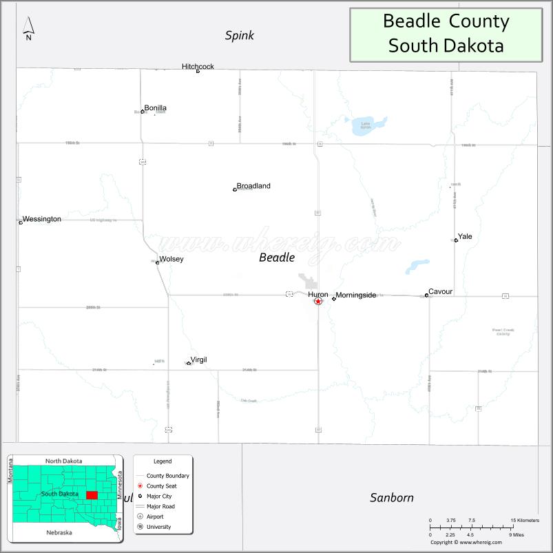
About Beadle County Map, South Dakota: The map showing the county boundary, county seat, major cities, highways, water bodies and neighbouring counties.
More South Dakota Maps & Info
About Beadle County, South Dakota
Beadle County is a county located in the U.S. state of South Dakota. It's county seat is Huron. As per 2020 census, the population of Beadle County is 19121 people and population density is square miles. According to the United States Census Bureau, the county has a total area of 1,259 sq mi (3,261 km2). Beadle County was established on 1879.
Beadle County Facts
| Continent | North America |
| Country | United States |
| State | South Dakota |
| County Seat | Huron |
| Largest City/Town | Huron |
| Established | 1879 |
| Total Area | 1,266 sq mi (3,279 sq km) |
| Land Area | 1,259 sq mi (3,261 sq km) |
| Water Area | 7 sq mi (18 sq km) |
| Population | 19,149 (Census 2020) |
| Population Density | 15.2 people per sq mi |
| Time Zone | Central Time Zone (CT) |
| Major Highways | US 14, SD 37, SD 27, SD 34 |
| Major Rivers | James River |
| Neighboring Counties | Spink County, Hand County, Jerauld County, Sanborn County, Kingsbury County |
| Famous For | South Dakota State Fair, agriculture, Huron, prairie landscapes |
| Top Attractions | South Dakota State Fairgrounds, Splash Central Waterpark, Dakota Nature Park, Huron Event Center |
| Official Website | Official Website |
About Beadle County, South Dakota
Beadle County is located in east-central South Dakota in the United States and was established in 1879. The county seat and largest city is Huron. The county is known for agriculture, the South Dakota State Fair, prairie landscapes, and regional commerce in central South Dakota.
Cities and Towns in Beadle County, South Dakota
| City/Town | Population (Census 2020) | Latitude & Longitude |
|---|---|---|
| Huron (county seat) | 14,263 | 44.3633°N, 98.2143°W |
| Cavour | 141 | 44.3636°N, 98.5228°W |
| Wessington | 170 | 44.4297°N, 98.6923°W |
| Yale | 23 | 44.5097°N, 98.3362°W |
| Wolsey | 418 | 44.4094°N, 98.4862°W |
| Virgil | 65 | 44.2989°N, 98.5659°W |
| Hitchcock nearby | 91 | 44.6272°N, 98.3490°W |
Golf Courses in Beadle County, South Dakota
| Golf Course | Location | Latitude & Longitude |
|---|---|---|
| Broadland Creek Golf Course | Huron | 44.3541°N, 98.2049°W |
| Huron Country Club | Huron | 44.3607°N, 98.1895°W |
| Lake Region Golf Club nearby | Arlington | 44.3642°N, 97.1315°W |
| Fisher Grove Golf Course nearby | Redfield | 44.8770°N, 98.5260°W |
Roads and Highways in Beadle County, South Dakota
Major highways connect the county to eastern and central South Dakota communities.
- US Highway 14 - major east-west route through Huron and central South Dakota
- South Dakota Highway 37 - north-south regional highway serving agricultural communities
- South Dakota Highway 27 - route connecting rural towns and farming regions
- South Dakota Highway 34 - regional roadway linking Huron with neighboring counties
What are Neighboring Counties of Beadle County
- Spink County (north)
- Hand County (west)
- Jerauld County (southwest)
- Sanborn County (south)
- Kingsbury County (east)
What are the Top Attractions in Beadle County, South Dakota
The county offers a mix of cultural, recreational, and historical attractions.
- South Dakota State Fairgrounds - major event venue hosting the annual South Dakota State Fair
- Splash Central Waterpark - family waterpark attraction in Huron
- Dakota Nature Park - outdoor recreation area with lakes, trails, and wildlife viewing
- Huron Event Center - venue for concerts, conventions, and community events
- Broadland Creek Golf Course - public golf destination in Huron
- Huron Downtown District - shopping, restaurants, and local businesses
- World’s Largest Pheasant statue - roadside attraction celebrating South Dakota pheasant hunting
- James River recreation areas - fishing, boating, and scenic prairie landscapes
- South Dakota Agricultural Heritage Museum exhibits nearby - regional farming history attractions
- Memorial Park in Huron - recreation and community event space
- Prairie wetlands and birdwatching areas - wildlife viewing opportunities
- Regional hunting destinations - pheasant hunting and outdoor sports tourism
- Historic railroad heritage sites - reflecting Huron’s transportation history
- County fairgrounds and local festivals - seasonal entertainment and agricultural events
What is the Distance from Beadle County to Nearby Cities
The following distances are measured by road (driving).
- Huron to Mitchell (Davison County), South Dakota - 74 mi (119 km)
- Huron to Brookings (Brookings County), South Dakota - 91 mi (146 km)
- Huron to Pierre (Hughes County), South Dakota - 116 mi (187 km)
- Huron to Sioux Falls (Minnehaha County), South Dakota - 122 mi (196 km)
- Huron to Aberdeen (Brown County), South Dakota - 83 mi (134 km)
- Huron to Watertown (Codington County), South Dakota - 89 mi (143 km)
- Huron to Rapid City (Pennington County), South Dakota - 313 mi (504 km)
- Huron to Fargo (Cass County), North Dakota - 227 mi (365 km)
- Huron to Omaha (Douglas County), Nebraska - 289 mi (465 km)
- Huron to Minneapolis (Hennepin County), Minnesota - 272 mi (438 km)
- Huron to Bismarck (Burleigh County), North Dakota - 282 mi (454 km)
- Huron to Denver (Denver County), Colorado - 596 mi (959 km)
FAQs about Beadle County
Beadle County is located in east-central South Dakota with Huron serving as the county seat.
Beadle County had a population of 19,149 according to the 2020 United States Census.
Beadle County is known for the South Dakota State Fair, agriculture, pheasant hunting, and prairie landscapes.
The major highways include US Highway 14, South Dakota Highway 37, Highway 27, and Highway 34.
Yes, Beadle County has golf facilities including Broadland Creek Golf Course and Huron Country Club.
References
- QuickFacts - U.S. Census Bureau
- United States Census Bureau
- United States Geological Survey (USGS)
- National Geodetic Survey
- Official Website
- Aurora County Map
- Beadle County Map
- Bennett County Map
- Bon Homme County Map
- Brookings County Map
- Brown County Map
- Brule County Map
- Buffalo County Map
- Butte County Map
- Campbell County Map
- Charles Mix County Map
- Clark County Map
- Clay County Map
- Codington County Map
- Corson County Map
- Custer County Map
- Davison County Map
- Day County Map
- Deuel County Map
- Dewey County Map
- Douglas County Map
- Edmunds County Map
- Fall River County Map
- Faulk County Map
- Grant County Map
- Gregory County Map
- Haakon County Map
- Hamlin County Map
- Hand County Map
- Hanson County Map
- Harding County Map
- Hughes County Map
- Hutchinson County Map
- Hyde County Map
- Jackson County Map
- Jerauld County Map
- Jones County Map
- Kingsbury County Map
- Lake County Map
- Lawrence County Map
- Lincoln County Map
- Lyman County Map
- McCook County Map
- McPherson County Map
- Marshall County Map
- Meade County Map
- Mellette County Map
- Miner County Map
- Minnehaha County Map
- Moody County Map
- Oglala Lakota County Map
- Pennington County Map
- Perkins County Map
- Potter County Map
- Roberts County Map
- Sanborn County Map
- Spink County Map
- Stanley County Map
- Sully County Map
- Todd County Map
- Tripp County Map
- Turner County Map
- Union County Map
- Walworth County Map
- Yankton County Map
- Ziebach County Map
- Alabama Counties
- Alaska boroughs
- Arizona Counties
- Arkansas Counties
- California County Map
- Colorado Counties
- Connecticut Counties
- Delaware Counties
- Florida County Map
- Georgia County Map
- Hawaii Counties
- Idaho Counties
- Illinois Counties
- Indiana Counties
- Iowa Counties
- Kansas Counties
- Kentucky Counties
- Louisiana Counties
- Maine Counties
- Maryland Counties
- Massachusetts Counties
- Michigan County Map
- Minnesota Counties
- Mississippi Counties
- Missouri Counties
- Montana Counties
- Nebraska Counties
- Nevada Counties
- New York Counties
- New Hampshire Counties
- New Jersey Counties
- New Mexico Counties
- North Carolina Counties
- North Dakota Counties
- Ohio County Map
- Oklahoma Counties
- Oregon Counties
- Pennsylvania Counties
- Rhode Island Counties
- South Carolina Counties
- South Dakota Counties
- Map of Tennessee
- Texas County Map
- Utah Counties
- Vermont Counties
- Virginia Counties
- Washington Counties
- West Virginia Counties
- Wisconsin Counties
- Wyoming Counties