Written and Fact-checked by Whereig Editors, Reviewed by Mukesh Kumar| Last Updated On: May 11, 2026
Map of Pennington County - Pennington County is a county located in the U.S. state of South Dakota. Pennington County Map showing cities, highways, important places and water bodies. Get Where is Pennington County located in the map, major cities in Pennington county, population, areas, and places of interest.
Map of Pennington County, South Dakota
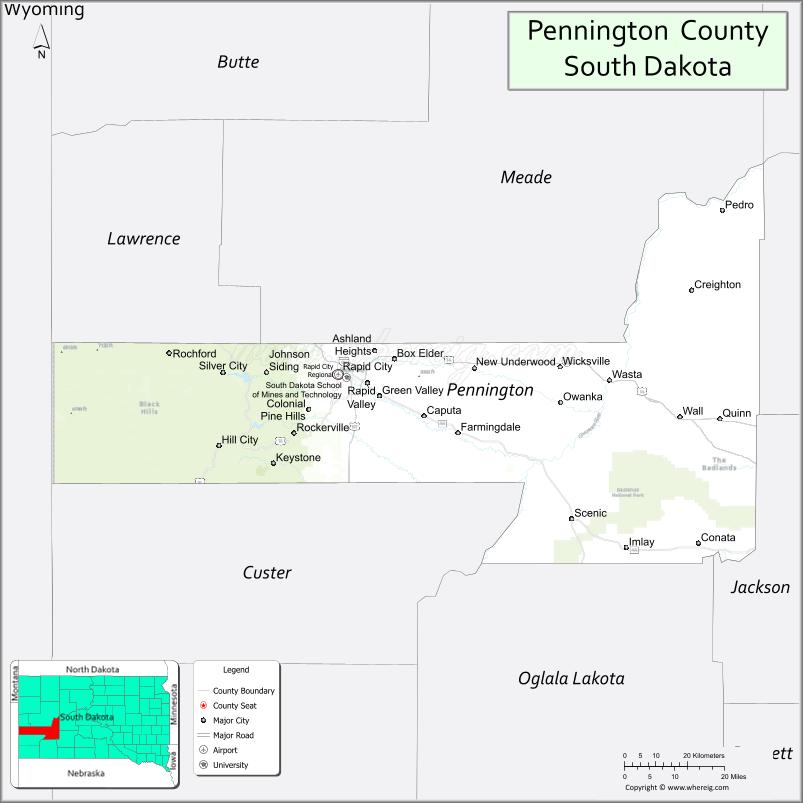
About Pennington County Map, South Dakota: The map showing the county boundary, county seat, major cities, highways, water bodies and neighbouring counties.
More South Dakota Maps & Info
About Pennington County, South Dakota
Pennington County is a county located in the U.S. state of South Dakota. It's county seat is Rapid City. As per 2020 census, the population of Pennington County is 111806 people and population density is square miles. According to the United States Census Bureau, the county has a total area of 2,776 sq mi (7,190 km2). Pennington County was established on 1875.
Pennington County Facts
| Continent | North America |
| Country | United States |
| State | South Dakota |
| County Seat | Rapid City |
| Largest City/Town | Rapid City |
| Established | 1875 |
| Total Area | 2,784 sq mi (7,211 sq km) |
| Land Area | 2,776 sq mi (7,191 sq km) |
| Water Area | 8 sq mi (21 sq km) |
| Population | 109,222 (Census 2020) |
| Population Density | 39.3 people per sq mi |
| Time Zone | Mountain Time Zone (MT) |
| Major Highways | Interstate 90, US 16, US 44 |
| Major Rivers | Cheyenne River, Rapid Creek |
| Neighboring Counties | Meade County, Haakon County, Jackson County, Custer County, Fall River County, Lawrence County |
| Famous For | Rapid City, Black Hills tourism, Mount Rushmore access, Ellsworth Air Force Base |
| Top Attractions | Badlands National Park nearby, Dinosaur Park, Journey Museum, Black Hills attractions |
| Official Website | Official Website |
About Pennington County, South Dakota
Pennington County is located in western South Dakota in the United States and was established in 1875. The county seat and largest city is Rapid City. The county is known for Black Hills tourism, outdoor recreation, access to Mount Rushmore and Badlands National Park, and its importance as a regional economic and cultural center.
Cities and Towns in Pennington County, South Dakota
| City/Town | Population (Census 2020) | Latitude & Longitude |
|---|---|---|
| Rapid City (county seat) | 74,703 | 44.0805°N, 103.2310°W |
| Box Elder | 11,746 | 44.1125°N, 103.0680°W |
| Hill City | 1,018 | 43.9325°N, 103.5741°W |
| Keystone | 240 | 43.8955°N, 103.4160°W |
| Wall | 664 | 43.9925°N, 102.2410°W |
| New Underwood | 616 | 44.1136°N, 102.8371°W |
Golf Courses in Pennington County, South Dakota
| Golf Course | Location | Latitude & Longitude |
|---|---|---|
| Hart Ranch Golf Club | Rapid City | 43.9778°N, 103.3112°W |
| Meadowbrook Golf Course | Rapid City | 44.0716°N, 103.2392°W |
| Red Rock Golf Club | Rapid City | 44.0865°N, 103.2982°W |
| Southern Hills Golf Course nearby | Hot Springs | 43.4317°N, 103.4748°W |
Roads and Highways in Pennington County, South Dakota
Major highways connect the county to the Black Hills region, tourism destinations, and western South Dakota communities.
- Interstate 90 - major east-west interstate highway across South Dakota
- US Highway 16 - scenic route connecting Rapid City and Mount Rushmore region
- US Highway 44 - important roadway serving Rapid City and Badlands areas
What are Neighboring Counties of Pennington County
- Meade County (north)
- Haakon County (east)
- Jackson County (southeast)
- Custer County (southwest)
- Fall River County (south)
- Lawrence County (northwest)
What are the Top Attractions in Pennington County, South Dakota
The county offers a mix of Black Hills scenery, national parks, museums, and outdoor recreation.
- Badlands National Park nearby - dramatic rock formations, hiking, and wildlife viewing
- Dinosaur Park - hilltop dinosaur sculptures overlooking Rapid City
- Journey Museum - exhibits on regional history, archaeology, and Native American culture
- Black Hills attractions - scenic drives, hiking trails, and outdoor adventures
- Mount Rushmore access routes - gateway to the famous national memorial
- Downtown Rapid City - shopping, restaurants, art galleries, and entertainment venues
- Reptile Gardens - family-friendly wildlife and reptile attraction
- Bear Country USA - drive-through wildlife park with native animals
- Ellsworth Air Force Base Museum nearby - aviation and military history exhibits
- Camping and RV parks throughout the county - outdoor recreation destinations
- Photography and wildlife viewing - mountain landscapes and prairie scenery
- Golf courses and recreation complexes - sports and leisure opportunities
- Historic Keystone and Hill City attractions - tourism and Black Hills culture
- Winter recreation and snow sports - seasonal Black Hills adventures
What is the Distance from Pennington County to Nearby Cities
The following distances are measured by road (driving).
- Rapid City to Sturgis (Meade County), South Dakota - 31 mi (50 km)
- Rapid City to Deadwood (Lawrence County), South Dakota - 42 mi (68 km)
- Rapid City to Wall (Pennington County), South Dakota - 56 mi (90 km)
- Rapid City to Hot Springs (Fall River County), South Dakota - 57 mi (92 km)
- Rapid City to Pierre (Hughes County), South Dakota - 188 mi (303 km)
- Rapid City to Casper (Natrona County), Wyoming - 280 mi (451 km)
- Rapid City to Billings (Yellowstone County), Montana - 315 mi (507 km)
- Rapid City to Denver (Denver County), Colorado - 389 mi (626 km)
- Rapid City to Sioux Falls (Minnehaha County), South Dakota - 348 mi (560 km)
- Rapid City to Bismarck (Burleigh County), North Dakota - 323 mi (520 km)
- Rapid City to Omaha (Douglas County), Nebraska - 518 mi (834 km)
- Rapid City to Minneapolis (Hennepin County), Minnesota - 626 mi (1,008 km)
FAQs about Pennington County
Pennington County is located in western South Dakota in the Black Hills region.
Pennington County had a population of 109,222 according to the 2020 United States Census.
Pennington County is known for Rapid City, Black Hills tourism, Mount Rushmore access, and outdoor recreation.
The major highways include Interstate 90, US Highway 16, and US Highway 44.
Yes, Pennington County has several golf facilities including Hart Ranch Golf Club, Meadowbrook Golf Course, and Red Rock Golf Club.
References
- QuickFacts - U.S. Census Bureau
- United States Census Bureau
- United States Geological Survey (USGS)
- National Geodetic Survey
- Official Website
- Aurora County Map
- Beadle County Map
- Bennett County Map
- Bon Homme County Map
- Brookings County Map
- Brown County Map
- Brule County Map
- Buffalo County Map
- Butte County Map
- Campbell County Map
- Charles Mix County Map
- Clark County Map
- Clay County Map
- Codington County Map
- Corson County Map
- Custer County Map
- Davison County Map
- Day County Map
- Deuel County Map
- Dewey County Map
- Douglas County Map
- Edmunds County Map
- Fall River County Map
- Faulk County Map
- Grant County Map
- Gregory County Map
- Haakon County Map
- Hamlin County Map
- Hand County Map
- Hanson County Map
- Harding County Map
- Hughes County Map
- Hutchinson County Map
- Hyde County Map
- Jackson County Map
- Jerauld County Map
- Jones County Map
- Kingsbury County Map
- Lake County Map
- Lawrence County Map
- Lincoln County Map
- Lyman County Map
- McCook County Map
- McPherson County Map
- Marshall County Map
- Meade County Map
- Mellette County Map
- Miner County Map
- Minnehaha County Map
- Moody County Map
- Oglala Lakota County Map
- Pennington County Map
- Perkins County Map
- Potter County Map
- Roberts County Map
- Sanborn County Map
- Spink County Map
- Stanley County Map
- Sully County Map
- Todd County Map
- Tripp County Map
- Turner County Map
- Union County Map
- Walworth County Map
- Yankton County Map
- Ziebach County Map
- Alabama Counties
- Alaska boroughs
- Arizona Counties
- Arkansas Counties
- California County Map
- Colorado Counties
- Connecticut Counties
- Delaware Counties
- Florida County Map
- Georgia County Map
- Hawaii Counties
- Idaho Counties
- Illinois Counties
- Indiana Counties
- Iowa Counties
- Kansas Counties
- Kentucky Counties
- Louisiana Counties
- Maine Counties
- Maryland Counties
- Massachusetts Counties
- Michigan County Map
- Minnesota Counties
- Mississippi Counties
- Missouri Counties
- Montana Counties
- Nebraska Counties
- Nevada Counties
- New York Counties
- New Hampshire Counties
- New Jersey Counties
- New Mexico Counties
- North Carolina Counties
- North Dakota Counties
- Ohio County Map
- Oklahoma Counties
- Oregon Counties
- Pennsylvania Counties
- Rhode Island Counties
- South Carolina Counties
- South Dakota Counties
- Map of Tennessee
- Texas County Map
- Utah Counties
- Vermont Counties
- Virginia Counties
- Washington Counties
- West Virginia Counties
- Wisconsin Counties
- Wyoming Counties