Written and Fact-checked by Whereig Editors, Reviewed by Mukesh Kumar| Last Updated On: May 11, 2026
Map of Jackson County - Jackson County is a county located in the U.S. state of South Dakota. Jackson County Map showing cities, highways, important places and water bodies. Get Where is Jackson County located in the map, major cities in Jackson county, population, areas, and places of interest.
Map of Jackson County, South Dakota
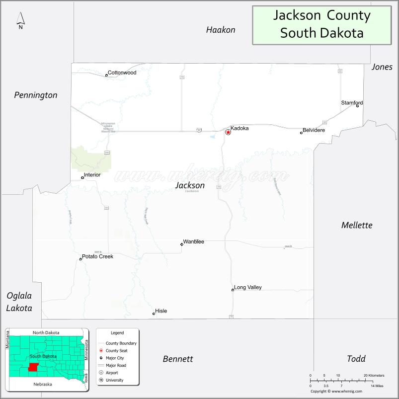
About Jackson County Map, South Dakota: The map showing the county boundary, county seat, major cities, highways, water bodies and neighbouring counties.
More South Dakota Maps & Info
About Jackson County, South Dakota
Jackson County is a county located in the U.S. state of South Dakota. It's county seat is Kadoka. As per 2020 census, the population of Jackson County is 2878 people and population density is square miles. According to the United States Census Bureau, the county has a total area of 1,869 sq mi (4,841 km2). Jackson County was established on 1914.
Jackson County Facts
| Continent | North America |
| Country | United States |
| State | South Dakota |
| County Seat | Kadoka |
| Largest City/Town | Kadoka |
| Established | 1883 |
| Total Area | 1,871 sq mi (4,846 sq km) |
| Land Area | 1,864 sq mi (4,828 sq km) |
| Water Area | 7 sq mi (18 sq km) |
| Population | 2,610 (Census 2020) |
| Population Density | 1.4 people per sq mi |
| Time Zone | Mountain Time Zone (MT) |
| Major Highways | Interstate 90, SD 73, SD 44 |
| Major Rivers | White River nearby |
| Neighboring Counties | Pennington County, Haakon County, Jones County, Mellette County, Bennett County, Oglala Lakota County |
| Famous For | Badlands region, ranching, prairie landscapes, outdoor recreation |
| Top Attractions | Badlands National Park nearby, Kadoka attractions, hunting areas, scenic prairie drives |
| Official Website | Official Website |
About Jackson County, South Dakota
Jackson County is located in southwestern South Dakota in the United States and was established in 1883. The county seat and largest city is Kadoka. The county is known for its proximity to Badlands National Park, ranching heritage, scenic prairie landscapes, and outdoor recreation opportunities.
Cities and Towns in Jackson County, South Dakota
| City/Town | Population (Census 2020) | Latitude & Longitude |
|---|---|---|
| Kadoka (county seat) | 605 | 43.8336°N, 101.5090°W |
| Interior | 94 | 43.7294°N, 101.9832°W |
| Long Valley | 21 | 43.8758°N, 101.1890°W |
| Belvidere | 47 | 43.8469°N, 101.1207°W |
| Wanblee nearby | 805 | 43.5661°N, 101.6671°W |
| Wall nearby | 664 | 43.9917°N, 102.2410°W |
Golf Courses in Jackson County, South Dakota
| Golf Course | Location | Latitude & Longitude |
|---|---|---|
| Wall Community Golf Course nearby | Wall | 43.9911°N, 102.2418°W |
| Lake Waggoner Golf Course nearby | Philip | 44.0428°N, 101.6718°W |
| Hart Ranch Golf Club nearby | Rapid City | 43.9778°N, 103.3112°W |
| Southern Hills Golf Course nearby | Hot Springs | 43.4329°N, 103.4832°W |
Roads and Highways in Jackson County, South Dakota
Major highways connect the county to the Badlands region, western South Dakota communities, and Interstate 90 travel routes.
- Interstate 90 - major east-west interstate highway across South Dakota
- South Dakota Highway 73 - scenic north-south route near Badlands landscapes
- South Dakota Highway 44 - regional roadway through ranching and prairie areas
What are Neighboring Counties of Jackson County
- Pennington County (west)
- Haakon County (north)
- Jones County (east)
- Mellette County (southeast)
- Bennett County (south)
- Oglala Lakota County (southwest)
What are the Top Attractions in Jackson County, South Dakota
The county offers a mix of dramatic Badlands scenery, prairie recreation, and western heritage attractions.
- Badlands National Park nearby - stunning rock formations, hiking trails, and scenic overlooks
- Kadoka attractions - local museums, restaurants, and visitor services
- Hunting areas - pheasant, deer, and prairie wildlife hunting opportunities
- Scenic prairie drives - panoramic Great Plains landscapes and ranch country
- Interior community attractions - gateway to Badlands recreation and camping
- Camping and RV parks near Badlands areas - outdoor recreation and travel destinations
- Photography and sunset viewing across Badlands landscapes - dramatic natural scenery
- Birdwatching and wildlife viewing - bison, prairie dogs, and migratory bird habitats
- Historic ranching communities - reflecting western South Dakota heritage
- Nearby Wall Drug attractions - famous roadside destination and shopping experiences
- White River recreation areas - fishing and outdoor exploration opportunities
- Regional rodeos and county fairs - celebrating ranching and cowboy traditions
- Stargazing and dark sky viewing - remote prairie night sky experiences
- Winter recreation and scenic travel opportunities - seasonal outdoor adventures
What is the Distance from Jackson County to Nearby Cities
The following distances are measured by road (driving).
- Kadoka to Wall (Pennington County), South Dakota - 36 mi (58 km)
- Kadoka to Rapid City (Pennington County), South Dakota - 86 mi (138 km)
- Kadoka to Pierre (Hughes County), South Dakota - 121 mi (195 km)
- Kadoka to Hot Springs (Fall River County), South Dakota - 126 mi (203 km)
- Kadoka to Casper (Natrona County), Wyoming - 259 mi (417 km)
- Kadoka to Sioux Falls (Minnehaha County), South Dakota - 302 mi (486 km)
- Kadoka to Bismarck (Burleigh County), North Dakota - 321 mi (517 km)
- Kadoka to Billings (Yellowstone County), Montana - 360 mi (579 km)
- Kadoka to Denver (Denver County), Colorado - 462 mi (744 km)
- Kadoka to Omaha (Douglas County), Nebraska - 474 mi (763 km)
- Kadoka to Fargo (Cass County), North Dakota - 452 mi (727 km)
- Kadoka to Minneapolis (Hennepin County), Minnesota - 552 mi (888 km)
FAQs about Jackson County
Jackson County is located in southwestern South Dakota near the Badlands region.
Jackson County had a population of 2,610 according to the 2020 United States Census.
Jackson County is known for Badlands scenery, ranching, prairie landscapes, and outdoor recreation.
The major highways include Interstate 90, South Dakota Highway 73, and South Dakota Highway 44.
Yes, Jackson County has access to nearby golf facilities including Wall Community Golf Course and regional golf clubs.
References
- QuickFacts - U.S. Census Bureau
- United States Census Bureau
- United States Geological Survey (USGS)
- National Geodetic Survey
- Official Website
- Aurora County Map
- Beadle County Map
- Bennett County Map
- Bon Homme County Map
- Brookings County Map
- Brown County Map
- Brule County Map
- Buffalo County Map
- Butte County Map
- Campbell County Map
- Charles Mix County Map
- Clark County Map
- Clay County Map
- Codington County Map
- Corson County Map
- Custer County Map
- Davison County Map
- Day County Map
- Deuel County Map
- Dewey County Map
- Douglas County Map
- Edmunds County Map
- Fall River County Map
- Faulk County Map
- Grant County Map
- Gregory County Map
- Haakon County Map
- Hamlin County Map
- Hand County Map
- Hanson County Map
- Harding County Map
- Hughes County Map
- Hutchinson County Map
- Hyde County Map
- Jackson County Map
- Jerauld County Map
- Jones County Map
- Kingsbury County Map
- Lake County Map
- Lawrence County Map
- Lincoln County Map
- Lyman County Map
- McCook County Map
- McPherson County Map
- Marshall County Map
- Meade County Map
- Mellette County Map
- Miner County Map
- Minnehaha County Map
- Moody County Map
- Oglala Lakota County Map
- Pennington County Map
- Perkins County Map
- Potter County Map
- Roberts County Map
- Sanborn County Map
- Spink County Map
- Stanley County Map
- Sully County Map
- Todd County Map
- Tripp County Map
- Turner County Map
- Union County Map
- Walworth County Map
- Yankton County Map
- Ziebach County Map
- Alabama Counties
- Alaska boroughs
- Arizona Counties
- Arkansas Counties
- California County Map
- Colorado Counties
- Connecticut Counties
- Delaware Counties
- Florida County Map
- Georgia County Map
- Hawaii Counties
- Idaho Counties
- Illinois Counties
- Indiana Counties
- Iowa Counties
- Kansas Counties
- Kentucky Counties
- Louisiana Counties
- Maine Counties
- Maryland Counties
- Massachusetts Counties
- Michigan County Map
- Minnesota Counties
- Mississippi Counties
- Missouri Counties
- Montana Counties
- Nebraska Counties
- Nevada Counties
- New York Counties
- New Hampshire Counties
- New Jersey Counties
- New Mexico Counties
- North Carolina Counties
- North Dakota Counties
- Ohio County Map
- Oklahoma Counties
- Oregon Counties
- Pennsylvania Counties
- Rhode Island Counties
- South Carolina Counties
- South Dakota Counties
- Map of Tennessee
- Texas County Map
- Utah Counties
- Vermont Counties
- Virginia Counties
- Washington Counties
- West Virginia Counties
- Wisconsin Counties
- Wyoming Counties