Written and Fact-checked by Whereig Editors, Reviewed by Mukesh Kumar| Last Updated On: May 11, 2026
Map of Lyman County - Lyman County is a county located in the U.S. state of South Dakota. Lyman County Map showing cities, highways, important places and water bodies. Get Where is Lyman County located in the map, major cities in Lyman county, population, areas, and places of interest.
Map of Lyman County, South Dakota
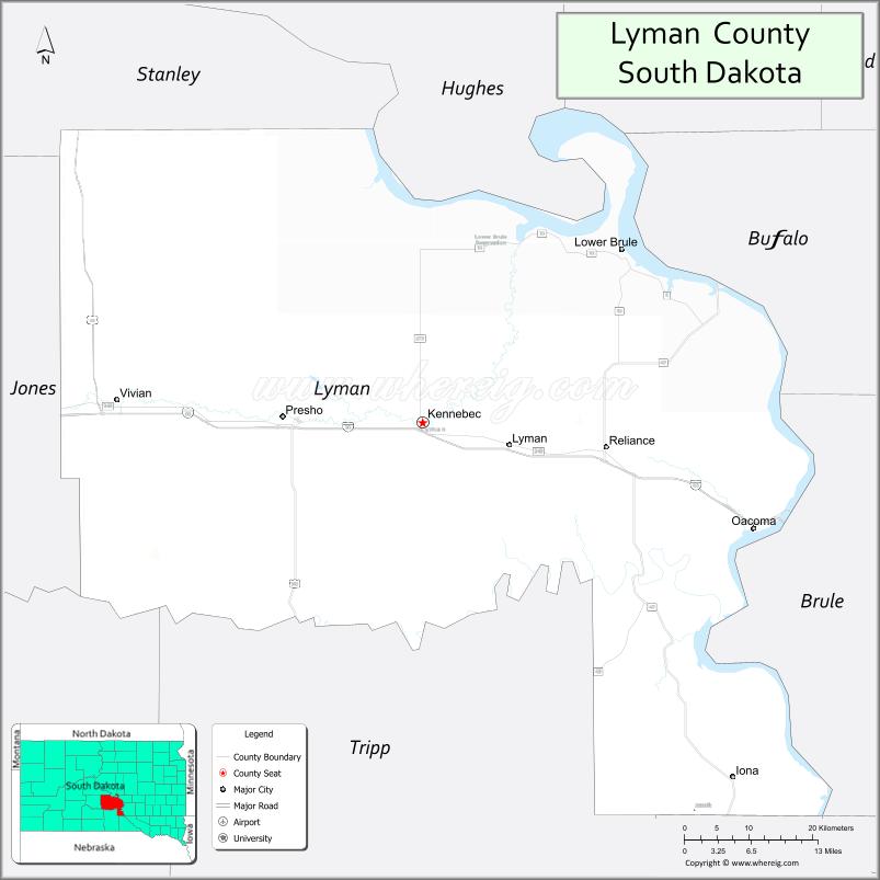
About Lyman County Map, South Dakota: The map showing the county boundary, county seat, major cities, highways, water bodies and neighbouring counties.
More South Dakota Maps & Info
About Lyman County, South Dakota
Lyman County is a county located in the U.S. state of South Dakota. It's county seat is Kennebec. As per 2020 census, the population of Lyman County is 3764 people and population density is square miles. According to the United States Census Bureau, the county has a total area of 1,640 sq mi (4,248 km2). Lyman County was established on 1873.
Lyman County Facts
| Continent | North America |
| Country | United States |
| State | South Dakota |
| County Seat | Kennebec |
| Largest City/Town | Presho |
| Established | 1873 |
| Total Area | 1,707 sq mi (4,421 sq km) |
| Land Area | 1,642 sq mi (4,253 sq km) |
| Water Area | 65 sq mi (168 sq km) |
| Population | 3,718 (Census 2020) |
| Population Density | 2.3 people per sq mi |
| Time Zone | Central Time Zone (CT) |
| Major Highways | Interstate 90, US 183, SD 47 |
| Major Rivers | Missouri River |
| Neighboring Counties | Stanley County, Jones County, Mellette County, Tripp County, Gregory County, Brule County, Buffalo County, Hughes County |
| Famous For | Missouri River recreation, ranching, Interstate 90 corridor, prairie landscapes |
| Top Attractions | Missouri River recreation areas, Presho attractions, hunting and fishing destinations, scenic prairie drives |
| Official Website | Official Website |
About Lyman County, South Dakota
Lyman County is located in central South Dakota in the United States and was established in 1873. The county seat is Kennebec, while Presho is the largest town in the county. The county is known for Missouri River recreation, ranching, agriculture, and scenic prairie landscapes along the Interstate 90 corridor.
Cities and Towns in Lyman County, South Dakota
| City/Town | Population (Census 2020) | Latitude & Longitude |
|---|---|---|
| Kennebec (county seat) | 281 | 43.9019°N, 99.8626°W |
| Presho | 472 | 43.9094°N, 100.0565°W |
| Reliance | 128 | 43.8761°N, 99.6081°W |
| Oacoma | 451 | 43.8100°N, 99.3787°W |
| Lower Brule nearby | 725 | 44.0775°N, 99.5815°W |
| Chamberlain nearby | 2,473 | 43.8108°N, 99.3307°W |
Golf Courses in Lyman County, South Dakota
| Golf Course | Location | Latitude & Longitude |
|---|---|---|
| Chamberlain Country Club nearby | Chamberlain | 43.8017°N, 99.3418°W |
| Oacoma Golf Course | Oacoma | 43.8148°N, 99.3841°W |
| Hillsview Golf Course nearby | Pierre | 44.3784°N, 100.3389°W |
| Winner Country Club nearby | Winner | 43.3781°N, 99.8593°W |
Roads and Highways in Lyman County, South Dakota
Major highways connect the county to central South Dakota communities, Missouri River recreation areas, and Interstate 90 travel routes.
- Interstate 90 - major east-west interstate highway across South Dakota
- US Highway 183 - north-south route through ranching and prairie regions
- South Dakota Highway 47 - regional roadway serving local communities
What are Neighboring Counties of Lyman County
- Hughes County (north)
- Buffalo County (northeast)
- Brule County (east)
- Gregory County (southeast)
- Tripp County (south)
- Mellette County (southwest)
- Jones County (west)
- Stanley County (northwest)
What are the Top Attractions in Lyman County, South Dakota
The county offers a mix of Missouri River recreation, prairie scenery, and western heritage attractions.
- Missouri River recreation areas - boating, fishing, kayaking, and water sports opportunities
- Presho attractions - local restaurants, shops, and small-town community events
- Hunting and fishing destinations - pheasant, deer, and walleye recreation areas
- Scenic prairie drives - panoramic Great Plains and ranchland landscapes
- Oacoma recreation areas - riverfront camping and outdoor activities
- Chamberlain attractions nearby - museums, riverfront parks, and cultural sites
- Camping and RV parks along the Missouri River - family recreation destinations
- Birdwatching and wildlife viewing - river habitats and prairie ecosystems
- Historic ranching communities - reflecting central South Dakota heritage
- Photography and sunset viewing along the Missouri River - scenic outdoor experiences
- Golf and recreation facilities - local and regional golf destinations
- Regional rodeos and county fairs - celebrating agriculture and cowboy traditions
- Fishing tournaments and boating events - popular river recreation activities
- Winter recreation and scenic road trips - seasonal prairie adventures
What is the Distance from Lyman County to Nearby Cities
The following distances are measured by road (driving).
- Presho to Pierre (Hughes County), South Dakota - 84 mi (135 km)
- Presho to Chamberlain (Brule County), South Dakota - 28 mi (45 km)
- Presho to Rapid City (Pennington County), South Dakota - 157 mi (253 km)
- Presho to Sioux Falls (Minnehaha County), South Dakota - 217 mi (349 km)
- Presho to Winner (Tripp County), South Dakota - 83 mi (134 km)
- Presho to Bismarck (Burleigh County), North Dakota - 285 mi (459 km)
- Presho to Casper (Natrona County), Wyoming - 332 mi (534 km)
- Presho to Omaha (Douglas County), Nebraska - 388 mi (624 km)
- Presho to Fargo (Cass County), North Dakota - 407 mi (655 km)
- Presho to Denver (Denver County), Colorado - 525 mi (845 km)
- Presho to Billings (Yellowstone County), Montana - 438 mi (705 km)
- Presho to Minneapolis (Hennepin County), Minnesota - 468 mi (753 km)
FAQs about Lyman County
Lyman County is located in central South Dakota along the Missouri River and Interstate 90 corridor.
Lyman County had a population of 3,718 according to the 2020 United States Census.
Lyman County is known for Missouri River recreation, ranching, prairie landscapes, and outdoor recreation.
The major highways include Interstate 90, US Highway 183, and South Dakota Highway 47.
Yes, Lyman County has golf facilities including Oacoma Golf Course and nearby regional golf clubs.
References
- QuickFacts - U.S. Census Bureau
- United States Census Bureau
- United States Geological Survey (USGS)
- National Geodetic Survey
- Official Website
- Aurora County Map
- Beadle County Map
- Bennett County Map
- Bon Homme County Map
- Brookings County Map
- Brown County Map
- Brule County Map
- Buffalo County Map
- Butte County Map
- Campbell County Map
- Charles Mix County Map
- Clark County Map
- Clay County Map
- Codington County Map
- Corson County Map
- Custer County Map
- Davison County Map
- Day County Map
- Deuel County Map
- Dewey County Map
- Douglas County Map
- Edmunds County Map
- Fall River County Map
- Faulk County Map
- Grant County Map
- Gregory County Map
- Haakon County Map
- Hamlin County Map
- Hand County Map
- Hanson County Map
- Harding County Map
- Hughes County Map
- Hutchinson County Map
- Hyde County Map
- Jackson County Map
- Jerauld County Map
- Jones County Map
- Kingsbury County Map
- Lake County Map
- Lawrence County Map
- Lincoln County Map
- Lyman County Map
- McCook County Map
- McPherson County Map
- Marshall County Map
- Meade County Map
- Mellette County Map
- Miner County Map
- Minnehaha County Map
- Moody County Map
- Oglala Lakota County Map
- Pennington County Map
- Perkins County Map
- Potter County Map
- Roberts County Map
- Sanborn County Map
- Spink County Map
- Stanley County Map
- Sully County Map
- Todd County Map
- Tripp County Map
- Turner County Map
- Union County Map
- Walworth County Map
- Yankton County Map
- Ziebach County Map
- Alabama Counties
- Alaska boroughs
- Arizona Counties
- Arkansas Counties
- California County Map
- Colorado Counties
- Connecticut Counties
- Delaware Counties
- Florida County Map
- Georgia County Map
- Hawaii Counties
- Idaho Counties
- Illinois Counties
- Indiana Counties
- Iowa Counties
- Kansas Counties
- Kentucky Counties
- Louisiana Counties
- Maine Counties
- Maryland Counties
- Massachusetts Counties
- Michigan County Map
- Minnesota Counties
- Mississippi Counties
- Missouri Counties
- Montana Counties
- Nebraska Counties
- Nevada Counties
- New York Counties
- New Hampshire Counties
- New Jersey Counties
- New Mexico Counties
- North Carolina Counties
- North Dakota Counties
- Ohio County Map
- Oklahoma Counties
- Oregon Counties
- Pennsylvania Counties
- Rhode Island Counties
- South Carolina Counties
- South Dakota Counties
- Map of Tennessee
- Texas County Map
- Utah Counties
- Vermont Counties
- Virginia Counties
- Washington Counties
- West Virginia Counties
- Wisconsin Counties
- Wyoming Counties