Written and Fact-checked by Whereig Editors, Reviewed by Mukesh Kumar| Last Updated On: May 11, 2026
Map of Kingsbury County - Kingsbury County is a county located in the U.S. state of South Dakota. Kingsbury County Map showing cities, highways, important places and water bodies. Get Where is Kingsbury County located in the map, major cities in Kingsbury county, population, areas, and places of interest.
Map of Kingsbury County, South Dakota
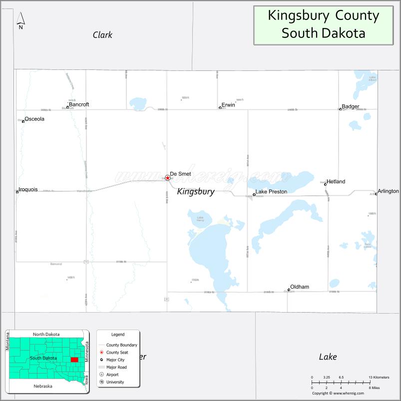
About Kingsbury County Map, South Dakota: The map showing the county boundary, county seat, major cities, highways, water bodies and neighbouring counties.
More South Dakota Maps & Info
About Kingsbury County, South Dakota
Kingsbury County is a county located in the U.S. state of South Dakota. It's county seat is De Smet. As per 2020 census, the population of Kingsbury County is 5192 people and population density is square miles. According to the United States Census Bureau, the county has a total area of 838 sq mi (2,170 km2). Kingsbury County was established on 1873.
Kingsbury County Facts
| Continent | North America |
| Country | United States |
| State | South Dakota |
| County Seat | De Smet |
| Largest City/Town | De Smet |
| Established | 1873 |
| Total Area | 864 sq mi (2,238 sq km) |
| Land Area | 832 sq mi (2,155 sq km) |
| Water Area | 32 sq mi (83 sq km) |
| Population | 5,187 (Census 2020) |
| Population Density | 6.2 people per sq mi |
| Time Zone | Central Time Zone (CT) |
| Major Highways | US 14, SD 25, SD 34 |
| Major Rivers | Big Sioux River watershed nearby |
| Neighboring Counties | Beadle County, Hamlin County, Brookings County, Miner County, Lake County, Sanborn County |
| Famous For | Laura Ingalls Wilder heritage, prairie lakes, agriculture, outdoor recreation |
| Top Attractions | Laura Ingalls Wilder Historic Homes, Lake Thompson, De Smet attractions, fishing and camping areas |
| Official Website | Official Website |
About Kingsbury County, South Dakota
Kingsbury County is located in eastern South Dakota in the United States and was established in 1873. The county seat and largest city is De Smet. The county is known for its connection to author Laura Ingalls Wilder, scenic prairie lakes, agriculture, and outdoor recreation opportunities.
Cities and Towns in Kingsbury County, South Dakota
| City/Town | Population (Census 2020) | Latitude & Longitude |
|---|---|---|
| De Smet (county seat) | 1,056 | 44.3875°N, 97.5503°W |
| Arlington | 915 | 44.3647°N, 97.1323°W |
| Lake Preston | 589 | 44.3681°N, 97.3709°W |
| Iroquois | 295 | 44.3686°N, 97.8504°W |
| Oldham | 135 | 44.2203°N, 97.3056°W |
| Badger nearby | 107 | 44.4880°N, 97.2081°W |
Golf Courses in Kingsbury County, South Dakota
| Golf Course | Location | Latitude & Longitude |
|---|---|---|
| Kingsbury County Country Club | De Smet | 44.3891°N, 97.5562°W |
| Lake Region Golf Club nearby | Lake Norden | 44.5859°N, 97.2207°W |
| Brookings Country Club nearby | Brookings | 44.3006°N, 96.7889°W |
| Prairie Winds Golf Club nearby | Milbank | 45.2185°N, 96.6334°W |
Roads and Highways in Kingsbury County, South Dakota
Major highways connect the county to eastern South Dakota communities, recreation areas, and prairie travel routes.
- US Highway 14 - major east-west route across eastern South Dakota
- South Dakota Highway 25 - north-south highway serving local communities
- South Dakota Highway 34 - regional roadway connecting prairie and lake areas
What are Neighboring Counties of Kingsbury County
- Hamlin County (north)
- Brookings County (east)
- Lake County (southeast)
- Miner County (south)
- Sanborn County (southwest)
- Beadle County (west)
What are the Top Attractions in Kingsbury County, South Dakota
The county offers a mix of literary history, lake recreation, and prairie scenery.
- Laura Ingalls Wilder Historic Homes - famous Little House on the Prairie heritage attractions in De Smet
- Lake Thompson - boating, fishing, camping, and water recreation destination
- De Smet attractions - museums, shops, restaurants, and historical sites
- Fishing and camping areas - outdoor recreation opportunities around county lakes
- Kingsbury County Country Club - golf and recreation facility
- Prairie scenic drives - rolling farmland and lake landscapes
- Birdwatching and wetland habitats - migratory bird viewing destinations
- Camping and RV parks - family-friendly outdoor recreation areas
- Historic downtown De Smet - preserved architecture and cultural attractions
- Lake Preston recreation areas - boating and fishing opportunities
- Regional fairs and community festivals - celebrating agriculture and local traditions
- Photography and sunset viewing across prairie lakes - scenic outdoor experiences
- Winter ice fishing and snowmobiling - seasonal recreation activities
- Historic railroad heritage attractions - reflecting prairie settlement history
What is the Distance from Kingsbury County to Nearby Cities
The following distances are measured by road (driving).
- De Smet to Brookings (Brookings County), South Dakota - 44 mi (71 km)
- De Smet to Watertown (Codington County), South Dakota - 57 mi (92 km)
- De Smet to Sioux Falls (Minnehaha County), South Dakota - 92 mi (148 km)
- De Smet to Huron (Beadle County), South Dakota - 55 mi (89 km)
- De Smet to Aberdeen (Brown County), South Dakota - 128 mi (206 km)
- De Smet to Fargo (Cass County), North Dakota - 212 mi (341 km)
- De Smet to Minneapolis (Hennepin County), Minnesota - 210 mi (338 km)
- De Smet to Pierre (Hughes County), South Dakota - 182 mi (293 km)
- De Smet to Omaha (Douglas County), Nebraska - 256 mi (412 km)
- De Smet to Rapid City (Pennington County), South Dakota - 389 mi (626 km)
- De Smet to Kansas City (Jackson County), Missouri - 479 mi (771 km)
- De Smet to Denver (Denver County), Colorado - 651 mi (1,048 km)
FAQs about Kingsbury County
Kingsbury County is located in eastern South Dakota in the prairie lakes region.
Kingsbury County had a population of 5,187 according to the 2020 United States Census.
Kingsbury County is known for Laura Ingalls Wilder history, prairie lakes, agriculture, and outdoor recreation.
The major highways include US Highway 14, South Dakota Highway 25, and South Dakota Highway 34.
Yes, Kingsbury County has golf facilities including Kingsbury County Country Club and nearby regional golf courses.
References
- QuickFacts - U.S. Census Bureau
- United States Census Bureau
- United States Geological Survey (USGS)
- National Geodetic Survey
- Official Website
- Aurora County Map
- Beadle County Map
- Bennett County Map
- Bon Homme County Map
- Brookings County Map
- Brown County Map
- Brule County Map
- Buffalo County Map
- Butte County Map
- Campbell County Map
- Charles Mix County Map
- Clark County Map
- Clay County Map
- Codington County Map
- Corson County Map
- Custer County Map
- Davison County Map
- Day County Map
- Deuel County Map
- Dewey County Map
- Douglas County Map
- Edmunds County Map
- Fall River County Map
- Faulk County Map
- Grant County Map
- Gregory County Map
- Haakon County Map
- Hamlin County Map
- Hand County Map
- Hanson County Map
- Harding County Map
- Hughes County Map
- Hutchinson County Map
- Hyde County Map
- Jackson County Map
- Jerauld County Map
- Jones County Map
- Kingsbury County Map
- Lake County Map
- Lawrence County Map
- Lincoln County Map
- Lyman County Map
- McCook County Map
- McPherson County Map
- Marshall County Map
- Meade County Map
- Mellette County Map
- Miner County Map
- Minnehaha County Map
- Moody County Map
- Oglala Lakota County Map
- Pennington County Map
- Perkins County Map
- Potter County Map
- Roberts County Map
- Sanborn County Map
- Spink County Map
- Stanley County Map
- Sully County Map
- Todd County Map
- Tripp County Map
- Turner County Map
- Union County Map
- Walworth County Map
- Yankton County Map
- Ziebach County Map
- Alabama Counties
- Alaska boroughs
- Arizona Counties
- Arkansas Counties
- California County Map
- Colorado Counties
- Connecticut Counties
- Delaware Counties
- Florida County Map
- Georgia County Map
- Hawaii Counties
- Idaho Counties
- Illinois Counties
- Indiana Counties
- Iowa Counties
- Kansas Counties
- Kentucky Counties
- Louisiana Counties
- Maine Counties
- Maryland Counties
- Massachusetts Counties
- Michigan County Map
- Minnesota Counties
- Mississippi Counties
- Missouri Counties
- Montana Counties
- Nebraska Counties
- Nevada Counties
- New York Counties
- New Hampshire Counties
- New Jersey Counties
- New Mexico Counties
- North Carolina Counties
- North Dakota Counties
- Ohio County Map
- Oklahoma Counties
- Oregon Counties
- Pennsylvania Counties
- Rhode Island Counties
- South Carolina Counties
- South Dakota Counties
- Map of Tennessee
- Texas County Map
- Utah Counties
- Vermont Counties
- Virginia Counties
- Washington Counties
- West Virginia Counties
- Wisconsin Counties
- Wyoming Counties