Written and Fact-checked by Whereig Editors, Reviewed by Mukesh Kumar| Last Updated On: May 11, 2026
Map of Perkins County - Perkins County is a county located in the U.S. state of South Dakota. Perkins County Map showing cities, highways, important places and water bodies. Get Where is Perkins County located in the map, major cities in Perkins county, population, areas, and places of interest.
Map of Perkins County, South Dakota
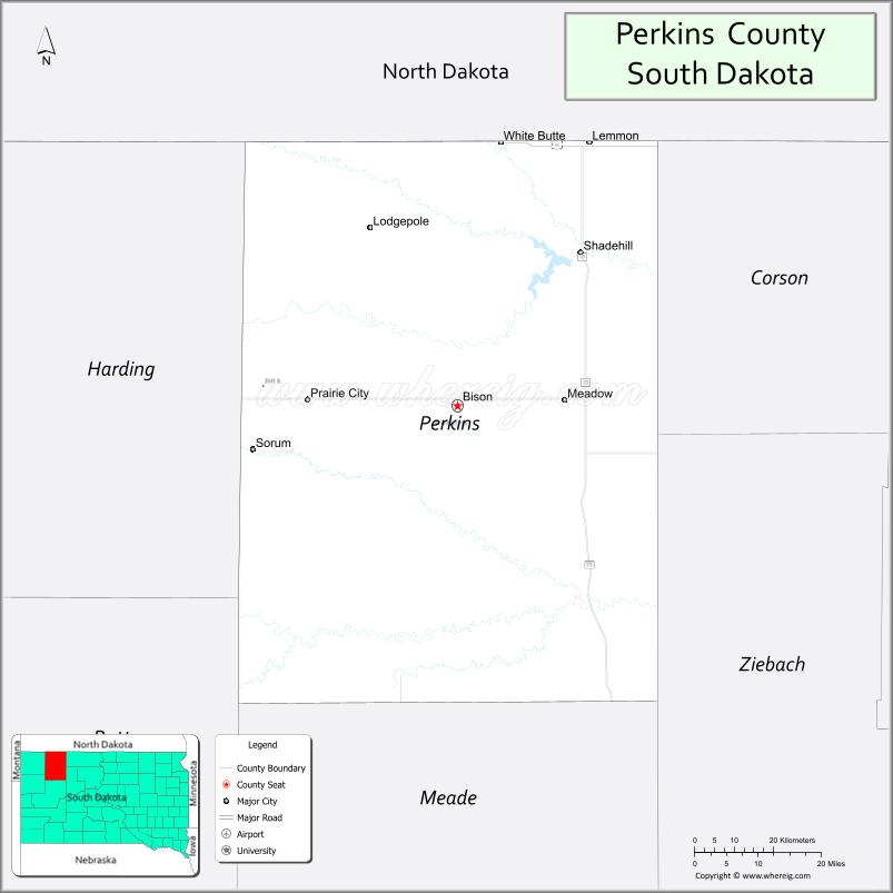
About Perkins County Map, South Dakota: The map showing the county boundary, county seat, major cities, highways, water bodies and neighbouring counties.
More South Dakota Maps & Info
About Perkins County, South Dakota
Perkins County is a county located in the U.S. state of South Dakota. It's county seat is Bison. As per 2020 census, the population of Perkins County is 2819 people and population density is square miles. According to the United States Census Bureau, the county has a total area of 2,872 sq mi (7,438 km2). Perkins County was established on 1909.
Perkins County Facts
| Continent | North America |
| Country | United States |
| State | South Dakota |
| County Seat | Bison |
| Largest City/Town | Lemmon |
| Established | 1909 |
| Total Area | 2,891 sq mi (7,488 sq km) |
| Land Area | 2,870 sq mi (7,433 sq km) |
| Water Area | 21 sq mi (54 sq km) |
| Population | 2,835 (Census 2020) |
| Population Density | 1.0 people per sq mi |
| Time Zone | Mountain Time Zone (MT) |
| Major Highways | US 12, US 85, SD 20 |
| Major Rivers | Grand River |
| Neighboring Counties | Corson County, Ziebach County, Meade County, Harding County, Adams County (ND), Bowman County (ND) |
| Famous For | Ranching, Grand River grasslands, prairie landscapes, fossil discoveries |
| Top Attractions | Petrified Wood Park, Shadehill Recreation Area nearby, Grand River scenery, prairie recreation |
| Official Website | Official Website |
About Perkins County, South Dakota
Perkins County is located in northwestern South Dakota in the United States and was established in 1909. The county seat is Bison, while Lemmon is the largest city. The county is known for ranching, wide-open prairie landscapes, Grand River grasslands, and unique geological and fossil attractions.
Cities and Towns in Perkins County, South Dakota
| City/Town | Population (Census 2020) | Latitude & Longitude |
|---|---|---|
| Bison (county seat) | 302 | 45.5205°N, 102.4615°W |
| Lemmon | 1,227 | 45.9397°N, 102.1590°W |
| Meadow | 7 | 45.4725°N, 102.2190°W |
| Prairie City | 16 | 45.5872°N, 102.8214°W |
| Lodgepole | 127 | 45.7367°N, 102.6618°W |
| Thunder Hawk nearby | 8 | 45.8141°N, 102.4759°W |
Golf Courses in Perkins County, South Dakota
| Golf Course | Location | Latitude & Longitude |
|---|---|---|
| Lemmon Country Club | Lemmon | 45.9425°N, 102.1673°W |
| Bison Golf Course | Bison | 45.5238°N, 102.4690°W |
| Hettinger Country Club nearby | Hettinger, North Dakota | 46.0019°N, 102.6415°W |
| Belle Fourche Country Club nearby | Belle Fourche | 44.6713°N, 103.8528°W |
Roads and Highways in Perkins County, South Dakota
Major highways connect the county to northwestern South Dakota communities, North Dakota, and regional ranching areas.
- US Highway 12 - major east-west route across northern South Dakota
- US Highway 85 - north-south highway connecting South Dakota and North Dakota
- South Dakota Highway 20 - regional route serving prairie communities
What are Neighboring Counties of Perkins County
- Corson County (east)
- Ziebach County (southeast)
- Meade County (south)
- Harding County (west)
- Adams County, North Dakota (north)
- Bowman County, North Dakota (northwest)
What are the Top Attractions in Perkins County, South Dakota
The county offers a mix of prairie recreation, western heritage, and scenic Great Plains landscapes.
- Petrified Wood Park - unique geological attraction featuring petrified wood structures and exhibits
- Shadehill Recreation Area nearby - boating, fishing, camping, and outdoor recreation
- Grand River scenery - scenic prairie river landscapes and wildlife viewing
- Prairie recreation destinations - hiking, photography, and countryside exploration
- Lemmon attractions - local museums, restaurants, and community events
- Ranching heritage sites - western South Dakota cowboy culture and traditions
- Birdwatching and wildlife viewing - prairie birds, antelope, and grassland ecosystems
- Camping and RV parks throughout the county - outdoor travel destinations
- Photography and sunset viewing across prairie landscapes - scenic outdoor experiences
- Fishing and hunting areas - pheasant, deer, and walleye recreation opportunities
- Regional rodeos and county fairs - celebrating agriculture and ranching traditions
- Lemmon Country Club - golf and recreation facility
- Historic downtown Lemmon - pioneer history and prairie culture attractions
- Winter recreation and scenic road trips - seasonal prairie adventures
What is the Distance from Perkins County to Nearby Cities
The following distances are measured by road (driving).
- Lemmon to Bismarck (Burleigh County), North Dakota - 106 mi (171 km)
- Lemmon to Mobridge (Walworth County), South Dakota - 112 mi (180 km)
- Lemmon to Rapid City (Pennington County), South Dakota - 185 mi (298 km)
- Lemmon to Dickinson (Stark County), North Dakota - 86 mi (138 km)
- Lemmon to Pierre (Hughes County), South Dakota - 218 mi (351 km)
- Lemmon to Billings (Yellowstone County), Montana - 309 mi (497 km)
- Lemmon to Fargo (Cass County), North Dakota - 309 mi (497 km)
- Lemmon to Sioux Falls (Minnehaha County), South Dakota - 448 mi (721 km)
- Lemmon to Casper (Natrona County), Wyoming - 320 mi (515 km)
- Lemmon to Denver (Denver County), Colorado - 540 mi (869 km)
- Lemmon to Minneapolis (Hennepin County), Minnesota - 471 mi (758 km)
- Lemmon to Omaha (Douglas County), Nebraska - 617 mi (993 km)
FAQs about Perkins County
Perkins County is located in northwestern South Dakota near the North Dakota border.
Perkins County had a population of 2,835 according to the 2020 United States Census.
Perkins County is known for ranching, prairie landscapes, Grand River scenery, and fossil attractions.
The major highways include US Highway 12, US Highway 85, and South Dakota Highway 20.
Yes, Perkins County has golf facilities including Lemmon Country Club and Bison Golf Course.
References
- QuickFacts - U.S. Census Bureau
- United States Census Bureau
- United States Geological Survey (USGS)
- National Geodetic Survey
- Official Website
- Aurora County Map
- Beadle County Map
- Bennett County Map
- Bon Homme County Map
- Brookings County Map
- Brown County Map
- Brule County Map
- Buffalo County Map
- Butte County Map
- Campbell County Map
- Charles Mix County Map
- Clark County Map
- Clay County Map
- Codington County Map
- Corson County Map
- Custer County Map
- Davison County Map
- Day County Map
- Deuel County Map
- Dewey County Map
- Douglas County Map
- Edmunds County Map
- Fall River County Map
- Faulk County Map
- Grant County Map
- Gregory County Map
- Haakon County Map
- Hamlin County Map
- Hand County Map
- Hanson County Map
- Harding County Map
- Hughes County Map
- Hutchinson County Map
- Hyde County Map
- Jackson County Map
- Jerauld County Map
- Jones County Map
- Kingsbury County Map
- Lake County Map
- Lawrence County Map
- Lincoln County Map
- Lyman County Map
- McCook County Map
- McPherson County Map
- Marshall County Map
- Meade County Map
- Mellette County Map
- Miner County Map
- Minnehaha County Map
- Moody County Map
- Oglala Lakota County Map
- Pennington County Map
- Perkins County Map
- Potter County Map
- Roberts County Map
- Sanborn County Map
- Spink County Map
- Stanley County Map
- Sully County Map
- Todd County Map
- Tripp County Map
- Turner County Map
- Union County Map
- Walworth County Map
- Yankton County Map
- Ziebach County Map
- Alabama Counties
- Alaska boroughs
- Arizona Counties
- Arkansas Counties
- California County Map
- Colorado Counties
- Connecticut Counties
- Delaware Counties
- Florida County Map
- Georgia County Map
- Hawaii Counties
- Idaho Counties
- Illinois Counties
- Indiana Counties
- Iowa Counties
- Kansas Counties
- Kentucky Counties
- Louisiana Counties
- Maine Counties
- Maryland Counties
- Massachusetts Counties
- Michigan County Map
- Minnesota Counties
- Mississippi Counties
- Missouri Counties
- Montana Counties
- Nebraska Counties
- Nevada Counties
- New York Counties
- New Hampshire Counties
- New Jersey Counties
- New Mexico Counties
- North Carolina Counties
- North Dakota Counties
- Ohio County Map
- Oklahoma Counties
- Oregon Counties
- Pennsylvania Counties
- Rhode Island Counties
- South Carolina Counties
- South Dakota Counties
- Map of Tennessee
- Texas County Map
- Utah Counties
- Vermont Counties
- Virginia Counties
- Washington Counties
- West Virginia Counties
- Wisconsin Counties
- Wyoming Counties