Written and Fact-checked by Whereig Editors, Reviewed by Mukesh Kumar| Last Updated On: May 11, 2026
Map of Dewey County - Dewey County is a county located in the U.S. state of South Dakota. Dewey County Map showing cities, highways, important places and water bodies. Get Where is Dewey County located in the map, major cities in Dewey county, population, areas, and places of interest.
Map of Dewey County, South Dakota
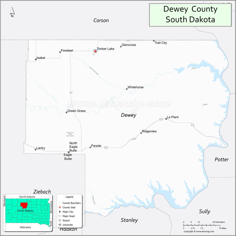
About Dewey County Map, South Dakota: The map showing the county boundary, county seat, major cities, highways, water bodies and neighbouring counties.
More South Dakota Maps & Info
About Dewey County, South Dakota
Dewey County is a county located in the U.S. state of South Dakota. It's county seat is Timber Lake. As per 2020 census, the population of Dewey County is 5246 people and population density is square miles. According to the United States Census Bureau, the county has a total area of 2,303 sq mi (5,965 km2). Dewey County was established on 1873.
Dewey County Facts
| Continent | North America |
| Country | United States |
| State | South Dakota |
| County Seat | Timber Lake |
| Largest City/Town | Eagle Butte |
| Established | 1883 |
| Total Area | 2,445 sq mi (6,332 sq km) |
| Land Area | 2,302 sq mi (5,962 sq km) |
| Water Area | 143 sq mi (370 sq km) |
| Population | 5,239 (Census 2020) |
| Population Density | 2.3 people per sq mi |
| Time Zone | Mountain Time Zone (MT) |
| Major Highways | US 212, SD 63, SD 65 |
| Major Rivers | Missouri River, Cheyenne River |
| Neighboring Counties | Corson County, Ziebach County, Stanley County, Sully County, Potter County, Walworth County |
| Famous For | Cheyenne River Sioux Reservation, prairie landscapes, Missouri River recreation, Native American heritage |
| Top Attractions | Cheyenne River Reservation cultural sites, Lake Oahe recreation, Eagle Butte attractions, fishing and hunting areas |
| Official Website | Official Website |
About Dewey County, South Dakota
Dewey County is located in north-central South Dakota in the United States and was established in 1883. The county seat is Timber Lake, while Eagle Butte is the largest community in the county. The county is known for Native American heritage, the Cheyenne River Sioux Reservation, Missouri River recreation, and vast prairie landscapes.
Cities and Towns in Dewey County, South Dakota
| City/Town | Population (Census 2020) | Latitude & Longitude |
|---|---|---|
| Eagle Butte | 1,258 | 44.9994°N, 101.2332°W |
| Timber Lake (county seat) | 443 | 45.0744°N, 101.0740°W |
| Isabel | 135 | 45.3997°N, 101.4292°W |
| Whitehorse | 106 | 45.2653°N, 100.9568°W |
| La Plant | 171 | 45.1280°N, 100.9709°W |
| Promise | 44 | 45.2916°N, 101.6610°W |
Golf Courses in Dewey County, South Dakota
| Golf Course | Location | Latitude & Longitude |
|---|---|---|
| Timber Lake Golf Course | Timber Lake | 45.0758°N, 101.0784°W |
| Mobridge Country Club nearby | Mobridge | 45.5358°N, 100.4334°W |
| Gettysburg Country Club nearby | Gettysburg | 44.9992°N, 99.9511°W |
| Selby Golf Club nearby | Selby | 45.5055°N, 100.0328°W |
Roads and Highways in Dewey County, South Dakota
Major highways connect the county to central South Dakota communities, reservations, and Missouri River recreation areas.
- US Highway 212 - major east-west highway across northern South Dakota
- South Dakota Highway 63 - north-south route connecting reservation communities
- South Dakota Highway 65 - scenic roadway serving prairie and river areas
What are Neighboring Counties of Dewey County
- Corson County (north)
- Ziebach County (west)
- Stanley County (south)
- Sully County (southeast)
- Potter County (east)
- Walworth County (northeast)
What are the Top Attractions in Dewey County, South Dakota
The county offers a mix of Native American culture, prairie scenery, and outdoor recreation.
- Cheyenne River Sioux Reservation cultural sites - tribal heritage and Native American history
- Lake Oahe recreation areas - boating, fishing, camping, and water sports
- Eagle Butte community attractions - local parks, cultural events, and dining
- Missouri River fishing destinations - walleye, northern pike, and catfish fishing
- Prairie scenic landscapes - rolling grasslands and Great Plains views
- Traditional powwows and tribal events - celebrations of Lakota culture and heritage
- Camping and RV parks near Lake Oahe - outdoor recreation opportunities
- Birdwatching and wildlife viewing areas - habitat for migratory birds and prairie wildlife
- Timber Lake recreation facilities - parks and family outdoor activities
- Cheyenne River cultural centers and historical sites - educational experiences
- Regional hunting areas - pheasant, deer, and waterfowl hunting destinations
- Scenic drives along prairie and reservoir landscapes - photography and sightseeing opportunities
- Community fairs and rodeos - local entertainment and agricultural traditions
- Lake Oahe shoreline access points - boating ramps and fishing piers
What is the Distance from Dewey County to Nearby Cities
The following distances are measured by road (driving).
- Eagle Butte to Mobridge (Walworth County), South Dakota - 64 mi (103 km)
- Eagle Butte to Pierre (Hughes County), South Dakota - 77 mi (124 km)
- Eagle Butte to Aberdeen (Brown County), South Dakota - 168 mi (270 km)
- Eagle Butte to Rapid City (Pennington County), South Dakota - 169 mi (272 km)
- Eagle Butte to Bismarck (Burleigh County), North Dakota - 186 mi (299 km)
- Eagle Butte to Fargo (Cass County), North Dakota - 341 mi (549 km)
- Eagle Butte to Sioux Falls (Minnehaha County), South Dakota - 290 mi (467 km)
- Eagle Butte to Billings (Yellowstone County), Montana - 371 mi (597 km)
- Eagle Butte to Minneapolis (Hennepin County), Minnesota - 470 mi (756 km)
- Eagle Butte to Omaha (Douglas County), Nebraska - 433 mi (697 km)
- Eagle Butte to Denver (Denver County), Colorado - 566 mi (911 km)
- Eagle Butte to Casper (Natrona County), Wyoming - 317 mi (510 km)
FAQs about Dewey County
Dewey County is located in north-central South Dakota along the Missouri River and Lake Oahe region.
Dewey County had a population of 5,239 according to the 2020 United States Census.
Dewey County is known for the Cheyenne River Sioux Reservation, prairie landscapes, fishing, and Missouri River recreation.
The major highways include US Highway 212, South Dakota Highway 63, and South Dakota Highway 65.
Yes, Dewey County has golf facilities including Timber Lake Golf Course and nearby regional golf clubs.
References
- QuickFacts - U.S. Census Bureau
- United States Census Bureau
- United States Geological Survey (USGS)
- National Geodetic Survey
- Official Website
- Aurora County Map
- Beadle County Map
- Bennett County Map
- Bon Homme County Map
- Brookings County Map
- Brown County Map
- Brule County Map
- Buffalo County Map
- Butte County Map
- Campbell County Map
- Charles Mix County Map
- Clark County Map
- Clay County Map
- Codington County Map
- Corson County Map
- Custer County Map
- Davison County Map
- Day County Map
- Deuel County Map
- Dewey County Map
- Douglas County Map
- Edmunds County Map
- Fall River County Map
- Faulk County Map
- Grant County Map
- Gregory County Map
- Haakon County Map
- Hamlin County Map
- Hand County Map
- Hanson County Map
- Harding County Map
- Hughes County Map
- Hutchinson County Map
- Hyde County Map
- Jackson County Map
- Jerauld County Map
- Jones County Map
- Kingsbury County Map
- Lake County Map
- Lawrence County Map
- Lincoln County Map
- Lyman County Map
- McCook County Map
- McPherson County Map
- Marshall County Map
- Meade County Map
- Mellette County Map
- Miner County Map
- Minnehaha County Map
- Moody County Map
- Oglala Lakota County Map
- Pennington County Map
- Perkins County Map
- Potter County Map
- Roberts County Map
- Sanborn County Map
- Spink County Map
- Stanley County Map
- Sully County Map
- Todd County Map
- Tripp County Map
- Turner County Map
- Union County Map
- Walworth County Map
- Yankton County Map
- Ziebach County Map
- Alabama Counties
- Alaska boroughs
- Arizona Counties
- Arkansas Counties
- California County Map
- Colorado Counties
- Connecticut Counties
- Delaware Counties
- Florida County Map
- Georgia County Map
- Hawaii Counties
- Idaho Counties
- Illinois Counties
- Indiana Counties
- Iowa Counties
- Kansas Counties
- Kentucky Counties
- Louisiana Counties
- Maine Counties
- Maryland Counties
- Massachusetts Counties
- Michigan County Map
- Minnesota Counties
- Mississippi Counties
- Missouri Counties
- Montana Counties
- Nebraska Counties
- Nevada Counties
- New York Counties
- New Hampshire Counties
- New Jersey Counties
- New Mexico Counties
- North Carolina Counties
- North Dakota Counties
- Ohio County Map
- Oklahoma Counties
- Oregon Counties
- Pennsylvania Counties
- Rhode Island Counties
- South Carolina Counties
- South Dakota Counties
- Map of Tennessee
- Texas County Map
- Utah Counties
- Vermont Counties
- Virginia Counties
- Washington Counties
- West Virginia Counties
- Wisconsin Counties
- Wyoming Counties