Written and Fact-checked by Whereig Editors, Reviewed by Mukesh Kumar| Last Updated On: May 11, 2026
Map of Stanley County - Stanley County is a county located in the U.S. state of South Dakota. Stanley County Map showing cities, highways, important places and water bodies. Get Where is Stanley County located in the map, major cities in Stanley county, population, areas, and places of interest.
Map of Stanley County, South Dakota
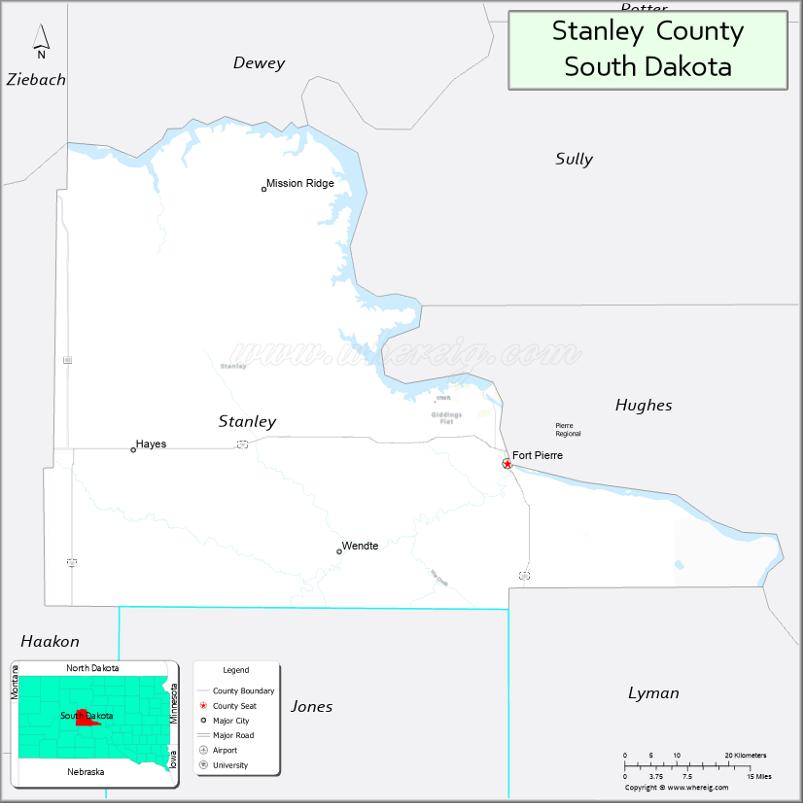
About Stanley County Map, South Dakota: The map showing the county boundary, county seat, major cities, highways, water bodies and neighbouring counties.
More South Dakota Maps & Info
About Stanley County, South Dakota
Stanley County is a county located in the U.S. state of South Dakota. It's county seat is Fort Pierre. As per 2020 census, the population of Stanley County is 3032 people and population density is square miles. According to the United States Census Bureau, the county has a total area of 1,443 sq mi (3,737 km2). Stanley County was established on 1873.
Stanley County Facts
| Continent | North America |
| Country | United States |
| State | South Dakota |
| County Seat | Fort Pierre |
| Largest City/Town | Fort Pierre |
| Established | 1873 |
| Total Area | 1,517 sq mi (3,929 sq km) |
| Land Area | 1,443 sq mi (3,737 sq km) |
| Water Area | 74 sq mi (192 sq km) |
| Population | 2,952 (Census 2020) |
| Population Density | 2.0 people per sq mi |
| Time Zone | Central Time Zone (CT) |
| Major Highways | US 14, US 83, SD 34 |
| Major Rivers | Missouri River |
| Neighboring Counties | Sully County, Hughes County, Haakon County, Jones County, Lyman County |
| Famous For | Missouri River recreation, Fort Pierre history, ranching, outdoor recreation |
| Top Attractions | Fort Pierre National Grassland, Missouri River recreation, Casey Tibbs Rodeo Center, historic Fort Pierre |
| Official Website | Official Website |
About Stanley County, South Dakota
Stanley County is located in central South Dakota in the United States and was established in 1873. The county seat and largest town is Fort Pierre. The county is known for Missouri River recreation, ranching heritage, prairie landscapes, and historic western culture.
Cities and Towns in Stanley County, South Dakota
| City/Town | Population (Census 2020) | Latitude & Longitude |
|---|---|---|
| Fort Pierre (county seat) | 2,404 | 44.3633°N, 100.3732°W |
| Hayes | 87 | 44.3658°N, 101.0015°W |
| Harrold | 84 | 44.5258°N, 99.7387°W |
| Midland nearby | 129 | 44.0764°N, 101.1568°W |
| Pierre nearby | 14,091 | 44.3683°N, 100.3510°W |
| Presho nearby | 472 | 43.9094°N, 100.0565°W |
Golf Courses in Stanley County, South Dakota
| Golf Course | Location | Latitude & Longitude |
|---|---|---|
| Hillsview Golf Course | Pierre | 44.3784°N, 100.3389°W |
| Oahe Downstream Recreation Area Golf nearby | Fort Pierre | 44.3674°N, 100.3905°W |
| Fisher Grove Country Club nearby | Redfield | 44.8846°N, 98.5235°W |
| Lakeview Golf Course nearby | Mitchell | 43.7145°N, 98.0224°W |
Roads and Highways in Stanley County, South Dakota
Major highways connect the county to central South Dakota communities and Missouri River recreation destinations.
- US Highway 14 - major east-west highway across central South Dakota
- US Highway 83 - important north-south route through central South Dakota
- South Dakota Highway 34 - regional roadway serving prairie and ranching areas
What are Neighboring Counties of Stanley County
- Sully County (north)
- Hughes County (east)
- Jones County (south)
- Lyman County (southwest)
- Haakon County (west)
What are the Top Attractions in Stanley County, South Dakota
The county offers a mix of Missouri River recreation, western history, and prairie outdoor adventures.
- Fort Pierre National Grassland - hiking, wildlife viewing, camping, and scenic prairie landscapes
- Missouri River recreation - boating, fishing, kayaking, and water sports opportunities
- Casey Tibbs Rodeo Center - celebrating rodeo history and western culture
- Historic Fort Pierre - frontier heritage, museums, and pioneer landmarks
- Oahe Downstream Recreation Area - camping, fishing, and family recreation
- Fort Pierre attractions - restaurants, local shops, and community events
- Fishing and hunting destinations - walleye fishing and pheasant hunting opportunities
- Prairie scenic drives - ranchland and Missouri River Valley landscapes
- Birdwatching and wildlife habitats - prairie ecosystems and migratory birds
- Camping and RV parks throughout the county - outdoor recreation destinations
- Photography and sunset viewing along the Missouri River - scenic outdoor experiences
- Regional rodeos and county fairs - celebrating ranching and cowboy traditions
- Historic churches and pioneer landmarks - reflecting local settlement history
- Nearby Pierre attractions - museums, shopping, and South Dakota State Capitol tours
What is the Distance from Stanley County to Nearby Cities
The following distances are measured by road (driving).
- Fort Pierre to Pierre (Hughes County), South Dakota - 2 mi (3 km)
- Fort Pierre to Rapid City (Pennington County), South Dakota - 186 mi (299 km)
- Fort Pierre to Mitchell (Davison County), South Dakota - 147 mi (237 km)
- Fort Pierre to Aberdeen (Brown County), South Dakota - 167 mi (269 km)
- Fort Pierre to Sioux Falls (Minnehaha County), South Dakota - 221 mi (356 km)
- Fort Pierre to Bismarck (Burleigh County), North Dakota - 226 mi (364 km)
- Fort Pierre to Fargo (Cass County), North Dakota - 352 mi (566 km)
- Fort Pierre to Billings (Yellowstone County), Montana - 458 mi (737 km)
- Fort Pierre to Omaha (Douglas County), Nebraska - 389 mi (626 km)
- Fort Pierre to Casper (Natrona County), Wyoming - 361 mi (581 km)
- Fort Pierre to Minneapolis (Hennepin County), Minnesota - 430 mi (692 km)
- Fort Pierre to Denver (Denver County), Colorado - 556 mi (895 km)
FAQs about Stanley County
Stanley County is located in central South Dakota along the Missouri River.
Stanley County had a population of 2,952 according to the 2020 United States Census.
Stanley County is known for Missouri River recreation, Fort Pierre history, ranching, and outdoor recreation.
The major highways include US Highway 14, US Highway 83, and South Dakota Highway 34.
Popular attractions include Fort Pierre National Grassland, Missouri River recreation areas, and the Casey Tibbs Rodeo Center.
References
- QuickFacts - U.S. Census Bureau
- United States Census Bureau
- United States Geological Survey (USGS)
- National Geodetic Survey
- Official Website
- Aurora County Map
- Beadle County Map
- Bennett County Map
- Bon Homme County Map
- Brookings County Map
- Brown County Map
- Brule County Map
- Buffalo County Map
- Butte County Map
- Campbell County Map
- Charles Mix County Map
- Clark County Map
- Clay County Map
- Codington County Map
- Corson County Map
- Custer County Map
- Davison County Map
- Day County Map
- Deuel County Map
- Dewey County Map
- Douglas County Map
- Edmunds County Map
- Fall River County Map
- Faulk County Map
- Grant County Map
- Gregory County Map
- Haakon County Map
- Hamlin County Map
- Hand County Map
- Hanson County Map
- Harding County Map
- Hughes County Map
- Hutchinson County Map
- Hyde County Map
- Jackson County Map
- Jerauld County Map
- Jones County Map
- Kingsbury County Map
- Lake County Map
- Lawrence County Map
- Lincoln County Map
- Lyman County Map
- McCook County Map
- McPherson County Map
- Marshall County Map
- Meade County Map
- Mellette County Map
- Miner County Map
- Minnehaha County Map
- Moody County Map
- Oglala Lakota County Map
- Pennington County Map
- Perkins County Map
- Potter County Map
- Roberts County Map
- Sanborn County Map
- Spink County Map
- Stanley County Map
- Sully County Map
- Todd County Map
- Tripp County Map
- Turner County Map
- Union County Map
- Walworth County Map
- Yankton County Map
- Ziebach County Map
- Alabama Counties
- Alaska boroughs
- Arizona Counties
- Arkansas Counties
- California County Map
- Colorado Counties
- Connecticut Counties
- Delaware Counties
- Florida County Map
- Georgia County Map
- Hawaii Counties
- Idaho Counties
- Illinois Counties
- Indiana Counties
- Iowa Counties
- Kansas Counties
- Kentucky Counties
- Louisiana Counties
- Maine Counties
- Maryland Counties
- Massachusetts Counties
- Michigan County Map
- Minnesota Counties
- Mississippi Counties
- Missouri Counties
- Montana Counties
- Nebraska Counties
- Nevada Counties
- New York Counties
- New Hampshire Counties
- New Jersey Counties
- New Mexico Counties
- North Carolina Counties
- North Dakota Counties
- Ohio County Map
- Oklahoma Counties
- Oregon Counties
- Pennsylvania Counties
- Rhode Island Counties
- South Carolina Counties
- South Dakota Counties
- Map of Tennessee
- Texas County Map
- Utah Counties
- Vermont Counties
- Virginia Counties
- Washington Counties
- West Virginia Counties
- Wisconsin Counties
- Wyoming Counties