Written and Fact-checked by Whereig Editors, Reviewed by Mukesh Kumar| Last Updated On: May 11, 2026
Map of Bon Homme County - Bon Homme County is a county located in the U.S. state of South Dakota. Bon Homme County Map showing cities, highways, important places and water bodies. Get Where is Bon Homme County located in the map, major cities in Bon Homme county, population, areas, and places of interest.
Map of Bon Homme County, South Dakota
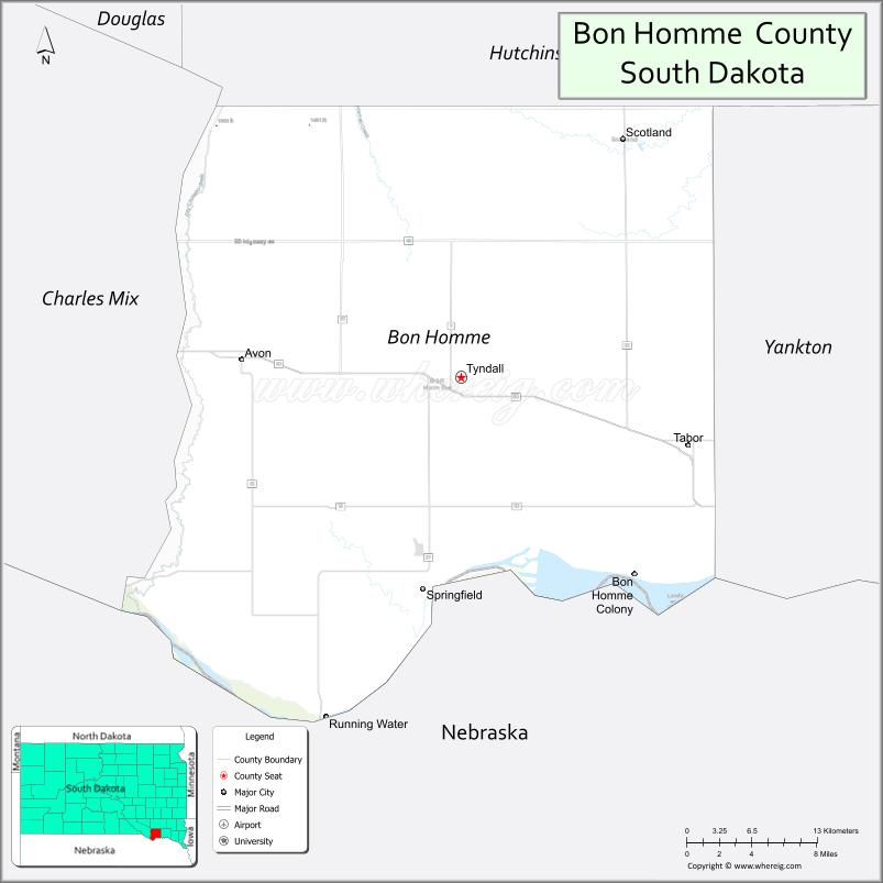
About Bon Homme County Map, South Dakota: The map showing the county boundary, county seat, major cities, highways, water bodies and neighbouring counties.
More South Dakota Maps & Info
About Bon Homme County, South Dakota
Bon Homme County is a county located in the U.S. state of South Dakota. It's county seat is Tyndall. As per 2020 census, the population of Bon Homme County is 7014 people and population density is square miles. According to the United States Census Bureau, the county has a total area of 563 sq mi (1,458 km2). Bon Homme County was established on 1862.
Bon Homme County Facts
| Continent | North America |
| Country | United States |
| State | South Dakota |
| County Seat | Tyndall |
| Largest City/Town | Tyndall |
| Established | 1862 |
| Total Area | 588 sq mi (1,523 sq km) |
| Land Area | 564 sq mi (1,461 sq km) |
| Water Area | 24 sq mi (62 sq km) |
| Population | 7,003 (Census 2020) |
| Population Density | 12.4 people per sq mi |
| Time Zone | Central Time Zone (CT) |
| Major Highways | US 18, US 281, SD 50 |
| Major Rivers | Missouri River |
| Neighboring Counties | Charles Mix County, Douglas County, Hutchinson County, Yankton County, Knox County (NE) |
| Famous For | Missouri River recreation, Lewis and Clark history, agriculture, Czech heritage |
| Top Attractions | Lewis and Clark Lake nearby, Springfield Recreation Area, Missouri River access, Tabor Czech heritage sites |
| Official Website | Official Website |
About Bon Homme County, South Dakota
Bon Homme County is located in southeastern South Dakota in the United States and was established in 1862. The county seat and largest town is Tyndall. The county is known for Missouri River recreation, agriculture, Czech and German heritage communities, and scenic river valley landscapes.
Cities and Towns in Bon Homme County, South Dakota
| City/Town | Population (Census 2020) | Latitude & Longitude |
|---|---|---|
| Tyndall (county seat) | 1,092 | 42.9997°N, 97.8617°W |
| Springfield | 1,986 | 42.8561°N, 97.8970°W |
| Tabor | 423 | 42.9480°N, 97.6587°W |
| Scotland | 785 | 43.1492°N, 97.7187°W |
| Avon | 590 | 43.0047°N, 97.8917°W |
| Wagner nearby | 1,566 | 43.0797°N, 98.2934°W |
Golf Courses in Bon Homme County, South Dakota
| Golf Course | Location | Latitude & Longitude |
|---|---|---|
| Fox Run Golf Course | Yankton nearby | 42.8711°N, 97.4245°W |
| Springfield Golf Course | Springfield | 42.8548°N, 97.9038°W |
| Scotland Golf Course | Scotland | 43.1481°N, 97.7215°W |
| Lakeview Golf Course nearby | Yankton | 42.8794°N, 97.3988°W |
Roads and Highways in Bon Homme County, South Dakota
Major highways connect the county to southeastern South Dakota and northeastern Nebraska.
- US Highway 18 - major east-west route through southern South Dakota
- US Highway 281 - north-south highway serving rural agricultural communities
- South Dakota Highway 50 - regional route connecting Springfield and nearby areas
What are Neighboring Counties of Bon Homme County
- Douglas County (northwest)
- Hutchinson County (north)
- Yankton County (east)
- Charles Mix County (west)
- Knox County, Nebraska (south)
What are the Top Attractions in Bon Homme County, South Dakota
The county offers a mix of river recreation, cultural heritage, and outdoor attractions.
- Lewis and Clark Lake nearby - boating, fishing, camping, and water recreation destination
- Springfield Recreation Area - Missouri River outdoor recreation and camping site
- Missouri River access points - fishing, kayaking, and scenic river views
- Tabor Czech heritage sites - cultural landmarks celebrating Czech immigration history
- Springfield downtown attractions - local shops, parks, and restaurants
- Bon Homme Colony nearby - Hutterite community and agricultural heritage
- Scotland community festivals - seasonal events and small-town celebrations
- Lewis and Clark Trail attractions nearby - historic exploration route sites
- Regional hunting and wildlife areas - pheasant hunting and birdwatching opportunities
- Rural scenic drives - rolling farmland and Missouri River valley landscapes
- Tyndall parks and recreation facilities - community sports and outdoor activities
- Fishing along the Missouri River - popular destination for anglers
- Nearby Gavins Point Dam region - water recreation and scenic overlooks
- Historic churches and ethnic heritage communities - reflecting Czech and German traditions
What is the Distance from Bon Homme County to Nearby Cities
The following distances are measured by road (driving).
- Tyndall to Yankton (Yankton County), South Dakota - 33 mi (53 km)
- Tyndall to Mitchell (Davison County), South Dakota - 73 mi (117 km)
- Tyndall to Sioux Falls (Minnehaha County), South Dakota - 95 mi (153 km)
- Springfield to Wagner (Charles Mix County), South Dakota - 22 mi (35 km)
- Tyndall to Pierre (Hughes County), South Dakota - 190 mi (306 km)
- Tyndall to Omaha (Douglas County), Nebraska - 170 mi (274 km)
- Tyndall to Norfolk (Madison County), Nebraska - 83 mi (134 km)
- Tyndall to Sioux City (Woodbury County), Iowa - 98 mi (158 km)
- Tyndall to Rapid City (Pennington County), South Dakota - 359 mi (578 km)
- Tyndall to Lincoln (Lancaster County), Nebraska - 197 mi (317 km)
- Tyndall to Fargo (Cass County), North Dakota - 344 mi (554 km)
- Tyndall to Minneapolis (Hennepin County), Minnesota - 304 mi (489 km)
FAQs about Bon Homme County
Bon Homme County is located in southeastern South Dakota along the Missouri River near Nebraska.
Bon Homme County had a population of 7,003 according to the 2020 United States Census.
Bon Homme County is known for Missouri River recreation, Czech heritage communities, agriculture, and Lewis and Clark history.
The major highways include US Highway 18, US Highway 281, and South Dakota Highway 50.
Yes, Bon Homme County has golf facilities including Springfield Golf Course and nearby regional golf clubs.
References
- QuickFacts - U.S. Census Bureau
- United States Census Bureau
- United States Geological Survey (USGS)
- National Geodetic Survey
- Official Website
- Aurora County Map
- Beadle County Map
- Bennett County Map
- Bon Homme County Map
- Brookings County Map
- Brown County Map
- Brule County Map
- Buffalo County Map
- Butte County Map
- Campbell County Map
- Charles Mix County Map
- Clark County Map
- Clay County Map
- Codington County Map
- Corson County Map
- Custer County Map
- Davison County Map
- Day County Map
- Deuel County Map
- Dewey County Map
- Douglas County Map
- Edmunds County Map
- Fall River County Map
- Faulk County Map
- Grant County Map
- Gregory County Map
- Haakon County Map
- Hamlin County Map
- Hand County Map
- Hanson County Map
- Harding County Map
- Hughes County Map
- Hutchinson County Map
- Hyde County Map
- Jackson County Map
- Jerauld County Map
- Jones County Map
- Kingsbury County Map
- Lake County Map
- Lawrence County Map
- Lincoln County Map
- Lyman County Map
- McCook County Map
- McPherson County Map
- Marshall County Map
- Meade County Map
- Mellette County Map
- Miner County Map
- Minnehaha County Map
- Moody County Map
- Oglala Lakota County Map
- Pennington County Map
- Perkins County Map
- Potter County Map
- Roberts County Map
- Sanborn County Map
- Spink County Map
- Stanley County Map
- Sully County Map
- Todd County Map
- Tripp County Map
- Turner County Map
- Union County Map
- Walworth County Map
- Yankton County Map
- Ziebach County Map
- Alabama Counties
- Alaska boroughs
- Arizona Counties
- Arkansas Counties
- California County Map
- Colorado Counties
- Connecticut Counties
- Delaware Counties
- Florida County Map
- Georgia County Map
- Hawaii Counties
- Idaho Counties
- Illinois Counties
- Indiana Counties
- Iowa Counties
- Kansas Counties
- Kentucky Counties
- Louisiana Counties
- Maine Counties
- Maryland Counties
- Massachusetts Counties
- Michigan County Map
- Minnesota Counties
- Mississippi Counties
- Missouri Counties
- Montana Counties
- Nebraska Counties
- Nevada Counties
- New York Counties
- New Hampshire Counties
- New Jersey Counties
- New Mexico Counties
- North Carolina Counties
- North Dakota Counties
- Ohio County Map
- Oklahoma Counties
- Oregon Counties
- Pennsylvania Counties
- Rhode Island Counties
- South Carolina Counties
- South Dakota Counties
- Map of Tennessee
- Texas County Map
- Utah Counties
- Vermont Counties
- Virginia Counties
- Washington Counties
- West Virginia Counties
- Wisconsin Counties
- Wyoming Counties