
Where is Wagner Located? - Wagner is a city located in the Charles Mix County of South Dakota, United States. Wagner lies between 45.5945645 Degrees North latitudes and 121.1786823 Degrees West longitudes.
Location Map of Wagner, South Dakota
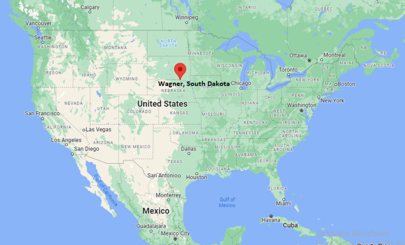
Wagner Map, South Dakota, USA
Where is Wagner?: The Google Map showing the location of Wagner in the U.S. state of South Dakota.
Where is Wagner Located?
Wagner is a city located in the Charles Mix County of South Dakota, United States. Wagner lies between 45.5945645 Degrees North latitudes and 121.1786823 Degrees West longitudes. According to 2020 U.S.census, the population of Wagner city is 1490 people and the city has a total area of 1.89 sq mi. The city has numerous parks and recreational facilities.
Most Viewed US Maps
| USA Sttae Map | USA Region Map | USA Road Map |
| USA County Map | Where is USA in World Map? | US ZIP Code Map |
| USA Time Zones Map | US State and Capitals Map | USA Physical Map |
Find 4,400+ U.S. Cities by State - Explore Their Locations and Get Detailed Information
Wagner, South Dakota Quick Facts
| Attribute | Details |
|---|---|
| City | Wagner |
| County | Charles Mix County |
| State | South Dakota |
| State Capital | Pierre |
| US Region | Midwestern United States |
| Latitude | 43.0792° N |
| Longitude | 98.2965° W |
| Elevation | Approximately 1,447 ft (441 m) |
| Land Area | 1.89 sq mi |
| Water Area | 0.01 sq mi |
| Total Area | 1.90 sq mi |
| Population (2020 Census) | 1,490 |
| Population Density | Approximately 788 per sq mi |
| ZIP Code | 57380 |
| Area Code | 605 |
| Time Zone Standard | Central Standard Time (CST), UTC−6 |
| Time Zone Daylight | Central Daylight Time (CDT), UTC−5 |
| Currency | United States Dollar (USD) |
| FIPS Code | 46-68020 |
| Community Type | City |
Transportation and Connectivity in Wagner, South Dakota
| Transportation | Details |
|---|---|
| Airport Name | Wagner Municipal Airport |
| IATA Code | Not assigned |
| Regional Airport | Sioux Falls Regional Airport |
| Major Highways | US Highway 18, South Dakota Highway 46, and nearby regional routes |
| Bus Service | YST Transit provides regional public transportation services |
| Rail Service | Rail service historically supported the community; nearby freight rail connections serve the region |
| Local Connectivity | Provides access to communities throughout Charles Mix County and southeastern South Dakota |
- US Highway 18 — Major east-west route connecting Wagner with surrounding South Dakota communities.
- South Dakota Highway 46 — Provides regional connections through southeastern South Dakota.
- Local County Roads — Support agricultural areas and rural communities surrounding Wagner.
Top Places to Visit in Wagner, South Dakota
| Landmark Name | Type |
|---|---|
| Fort Randall Casino and Resort | Entertainment Facility |
| Wagner Lake | Recreation Area |
| Fort Randall Dam | Historic and Recreation Site |
| Lake Francis Case | Reservoir |
| Chamberlain Bridge Area | Scenic Landmark |
| Akta Lakota Museum and Cultural Center | Cultural Museum |
| Fort Randall National Historic Site | Historic Site |
| Missouri River Recreation Areas | Outdoor Recreation Area |
| Wagner Community Memorial Park | City Park |
| Charles Mix County Recreation Areas | Outdoor Recreation |
Driving Distances from Wagner, South Dakota to Nearby Cities
| City | State | Distance (mi) | Approx. Drive Time |
|---|---|---|---|
| Yankton | South Dakota | 75 mi | 1 hour 20 minutes |
| Mitchell | South Dakota | 95 mi | 1 hour 40 minutes |
| Sioux Falls | South Dakota | 170 mi | 2 hours 45 minutes |
| Pierre | South Dakota | 145 mi | 2 hours 30 minutes |
| Chamberlain | South Dakota | 80 mi | 1 hour 20 minutes |
| Rapid City | South Dakota | 300 mi | 5 hours |
| Omaha | Nebraska | 180 mi | 3 hours |
| Lincoln | Nebraska | 250 mi | 4 hours |
| Des Moines | Iowa | 330 mi | 5 hours |
| Minneapolis | Minnesota | 390 mi | 6 hours |
Colleges and Universities Near Wagner, South Dakota
| Institution Name | Type | Level | Notable For |
|---|---|---|---|
| University of South Dakota | Public | University | Law, health sciences, business, education, and liberal arts programs |
| Southeast Technical College | Public | Technical College | Career training, technology, healthcare, and skilled trades programs |
| Mitchell Technical College | Public | Technical College | Energy, agriculture, technology, and workforce education |
| South Dakota State University | Public | University | Agriculture, engineering, sciences, nursing, and research programs |
| Mount Marty University | Private | University | Health sciences, nursing, education, and liberal arts programs |
Waterbodies Near Wagner, South Dakota
Missouri River, Lake Francis Case, Wagner Lake, Fort Randall Reservoir, and nearby southeastern South Dakota waterways provide opportunities for fishing, boating, camping, and outdoor recreation.
Golf Courses and Stadiums Near Wagner
Golf Courses: Wagner Golf Course and nearby regional golf facilities in southeastern South Dakota. Stadiums and sports facilities include Wagner Community School athletic facilities, local baseball fields, and community recreation areas.
Key Landmarks and Places to Visit in Wagner, South Dakota
| Landmark Name | Type |
|---|---|
| Fort Randall Dam | Historic and Recreation Site |
| Lake Francis Case | Reservoir and Recreation Area |
| Fort Randall National Historic Site | Historic Landmark |
| Akta Lakota Museum and Cultural Center | Cultural Museum |
| Missouri River Recreation Areas | Outdoor Recreation Area |
| Wagner Lake | Local Recreation Area |
| Fort Randall Casino and Resort | Entertainment Facility |
| Charles Mix County Historical Sites | Historic Sites |
| Wagner Community Memorial Park | City Park |
| Lake Andes National Wildlife Refuge | Wildlife Refuge |
Wagner, South Dakota — Key Historical Facts
- The Wagner area has a long history connected to Native American cultures, including the Yankton Sioux Tribe, who have lived in the region for generations.
- European-American settlement expanded in southeastern South Dakota during the late 19th century with the development of railroads and agricultural communities.
- The city of Wagner was founded in the late 1800s and grew as a local center for farming, trade, and community services.
- The Missouri River has played an important role in the history, transportation, and economy of the region.
- Fort Randall, established in the 1850s, served as a military post and played a significant role in the history of the Missouri River frontier.
- The construction of Fort Randall Dam in the 1950s created Lake Francis Case, transforming the area into a major recreation destination.
- Agriculture, ranching, local businesses, and regional services continue to support Wagner’s economy.
- Today, Wagner is known for its small-town community, outdoor recreation, Native American heritage, and connection to the Missouri River region.
References
- United States Census Bureau
- City of Wagner Official Website
- Charles Mix County Official Website
- State of South Dakota Official Website
- South Dakota Tourism
More South Dakota Maps & Info
- Where is Aberdeen
- Where is Belle Fourche
- Where is Beresford
- Where is Blackhawk
- Where is Box Elder
- Where is Brandon
- Where is Brookings
- Where is Canton
- Where is Chamberlain
- Where is Colonial Pine Hills
- Where is Crooks
- Where is Custer
- Where is Dell Rapids
- Where is Elk Point
- Where is Flandreau
- Where is Fort Pierre
- Where is Harrisburg
- Where is Hartford
- Where is Hot Springs
- Where is Huron
- Where is Lead
- Where is Lennox
- Where is Milbank
- Where is Mitchell
- Where is Mobridge
- Where is North Eagle Butte
- Where is North Sioux City
- Where is North Spearfish
- Where is Parkston
- Where is Pierre
- Where is Pine Ridge
- Where is Rapid City
- Where is Rapid Valley
- Where is Redfield
- Where is Rosebud
- Where is Sioux Falls
- Where is Sisseton
- Where is Spearfish
- Where is Sturgis
- Where is Summerset
- Where is Tea
- Where is Vermillion
- Where is Volga
- Where is Wagner
- Where is Watertown
- Where is Webster
- Where is Winner
- Where is Yankton