
Where is Milbank Located? - Milbank is a city located in the Grant County of South Dakota, United States. Milbank lies between 45.3556099 Degrees North latitudes and 122.605853 Degrees West longitudes.
Location Map of Milbank, South Dakota
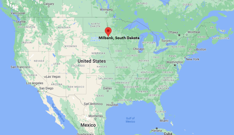
Milbank Map, South Dakota, USA
Where is Milbank?: The Google Map showing the location of Milbank in the U.S. state of South Dakota.
Where is Milbank Located?
Milbank is a city located in the Grant County of South Dakota, United States. Milbank lies between 45.3556099 Degrees North latitudes and 122.605853 Degrees West longitudes. According to 2020 U.S.census, the population of Milbank city is 3544 people and the city has a total area of 2.82 sq mi. The city has numerous parks and recreational facilities.
Most Viewed US Maps
| USA Sttae Map | USA Region Map | USA Road Map |
| USA County Map | Where is USA in World Map? | US ZIP Code Map |
| USA Time Zones Map | US State and Capitals Map | USA Physical Map |
Find 4,400+ U.S. Cities by State - Explore Their Locations and Get Detailed Information
Milbank, South Dakota Quick Facts
| Attribute | Details |
|---|---|
| City | Milbank |
| County | Grant County |
| State | South Dakota |
| State Capital | Pierre |
| US Region | Midwestern United States (Great Plains Region) |
| Latitude | 45.2197° N |
| Longitude | 96.6359° W |
| Elevation | 1,184 ft (361 m) |
| Land Area | 2.84 sq mi |
| Water Area | 0.04 sq mi |
| Total Area | 2.88 sq mi |
| Population (2020 Census) | 3,544 |
| Population Density | 1,248 per sq mi |
| ZIP Code(s) | 57252 |
| Area Code(s) | 605 |
| Time Zone Standard | Central Standard Time (CST, UTC−6) |
| Time Zone Daylight | Central Daylight Time (CDT, UTC−5) |
| Currency | United States Dollar (USD) |
| FIPS Code | 46-42580 |
| Congressional District | South Dakota At-Large Congressional District |
Transportation and Connectivity in Milbank
| Category | Details |
|---|---|
| Airport Name | Watertown Regional Airport |
| IATA Code | ATY |
| Major Highways | U.S. Highway 12, South Dakota Highway 15, South Dakota Highway 20 |
| Train Service | No passenger rail service; freight rail connections available |
| Local Transit Service | Regional transportation services available in Grant County |
- Milbank is located in Grant County, South Dakota, in the northeastern part of the state.
- The city serves as a regional center for agriculture, business, education, and community services.
- Milbank is known for its small-town character, historic downtown, parks, and nearby outdoor recreation areas.
- The community developed as a railroad town and grew through farming and local commerce.
Top Places to Visit in Milbank, South Dakota
| Landmark Name | Type |
|---|---|
| Big Stone Lake State Park (nearby) | State Park |
| Big Stone Lake | Lake Recreation Area |
| St. Lawrence Community Center | Community Facility |
| Milbank Area Museum | History Museum |
| Grant County Courthouse | Historic Government Building |
| South Dakota State Railroad Museum (nearby) | Railroad Museum |
| Whetstone Valley Golf Course | Golf Course |
| Milbank City Park | Community Park |
| Big Stone National Wildlife Refuge (nearby) | Wildlife Refuge |
| Lake Traverse (nearby) | Lake Recreation Area |
Driving Distances from Milbank, South Dakota to Nearby Cities
| City | State | Distance (mi) | Approx. Drive Time |
|---|---|---|---|
| Watertown | South Dakota | 45 | 50 minutes |
| Aberdeen | South Dakota | 100 | 1 hour 45 minutes |
| Brookings | South Dakota | 95 | 1 hour 40 minutes |
| Sioux Falls | South Dakota | 150 | 2 hours 30 minutes |
| Fargo | North Dakota | 150 | 2 hours 30 minutes |
| Bismarck | North Dakota | 330 | 5 hours |
| Rapid City | South Dakota | 420 | 6 hours |
| Minneapolis | Minnesota | 180 | 3 hours |
| Omaha | Nebraska | 300 | 5 hours |
| Sioux City | Iowa | 220 | 3 hours 30 minutes |
Colleges and Universities Near Milbank, South Dakota
| Institution Name | Type | Level | Notable For |
|---|---|---|---|
| Lake Area Technical College | Public | Technical College | Agriculture, technology, healthcare, and career training programs |
| Sisseton Wahpeton College | Tribal College | College | Native American studies, science, business, and education |
| University of South Dakota | Public | Research University | Law, medicine, business, education, and liberal arts |
| South Dakota State University | Public | Research University | Agriculture, engineering, sciences, and research |
| University of Minnesota Morris | Public | Liberal Arts College | Arts, sciences, environmental studies, and education |
Waterbodies Near Milbank, South Dakota
Milbank is located in northeastern South Dakota near several lakes, rivers, and wetlands. Major nearby water resources include Big Stone Lake, Whetstone River, Big Stone National Wildlife Refuge wetlands, and the Minnesota River watershed. These waterways provide opportunities for fishing, boating, wildlife viewing, and outdoor recreation.
Stadiums and Sports Facilities Near Milbank
Milbank features community sports facilities including local athletic fields, school sports complexes, parks, and recreation areas. Nearby communities provide additional sports venues for baseball, football, basketball, and regional events.
Milbank, South Dakota — Key Historical Facts
- Milbank was founded in 1878 as a railroad community along the Chicago, Milwaukee and St. Paul Railway.
- The city was named after railroad executive Jeremiah Milbank, who supported the development of the railway system.
- Milbank was officially incorporated in 1880 and became the county seat of Grant County.
- The arrival of the railroad helped establish Milbank as an important agricultural shipping and trade center.
- Farming, livestock production, and local businesses have played important roles in the city's economy.
- The community has preserved historic buildings and landmarks reflecting its railroad and agricultural heritage.
- Milbank has developed as a regional center for education, healthcare, retail, and public services.
- Today, Milbank is recognized for its small-town atmosphere, outdoor recreation opportunities, and strong connection to northeastern South Dakota's agricultural heritage.
References
- City of Milbank, South Dakota
- Grant County, South Dakota
- U.S. Census Bureau
- South Dakota Game, Fish and Parks
- Travel South Dakota Tourism
More South Dakota Maps & Info
- Where is Aberdeen
- Where is Belle Fourche
- Where is Beresford
- Where is Blackhawk
- Where is Box Elder
- Where is Brandon
- Where is Brookings
- Where is Canton
- Where is Chamberlain
- Where is Colonial Pine Hills
- Where is Crooks
- Where is Custer
- Where is Dell Rapids
- Where is Elk Point
- Where is Flandreau
- Where is Fort Pierre
- Where is Harrisburg
- Where is Hartford
- Where is Hot Springs
- Where is Huron
- Where is Lead
- Where is Lennox
- Where is Milbank
- Where is Mitchell
- Where is Mobridge
- Where is North Eagle Butte
- Where is North Sioux City
- Where is North Spearfish
- Where is Parkston
- Where is Pierre
- Where is Pine Ridge
- Where is Rapid City
- Where is Rapid Valley
- Where is Redfield
- Where is Rosebud
- Where is Sioux Falls
- Where is Sisseton
- Where is Spearfish
- Where is Sturgis
- Where is Summerset
- Where is Tea
- Where is Vermillion
- Where is Volga
- Where is Wagner
- Where is Watertown
- Where is Webster
- Where is Winner
- Where is Yankton