
Where is East Chicago Located? - East Chicago is a city located in the Lake County of Indiana, United States. East Chicago lies between 38.4784 Degrees North latitudes and 82.6379 Degrees West longitudes.
Location Map of East Chicago, Indiana
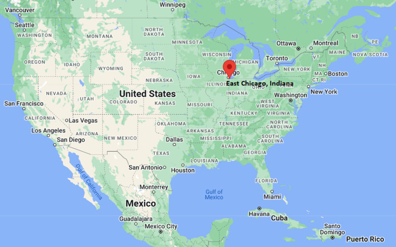
East Chicago Map, Indiana, USA
Where is East Chicago?: The Google Map showing the location of East Chicago in the U.S. state of Indiana.
Where is East Chicago Located?
East Chicago is a city located in the Lake County of Indiana, United States. East Chicago lies between 38.4784 Degrees North latitudes and 82.6379 Degrees West longitudes. According to 2020 U.S.census, the population of East Chicago city is 26370 people and the city has a total area of 14.09 sq mi. The city has numerous parks and recreational facilities.
Most Viewed US Maps
| USA Sttae Map | USA Region Map | USA Road Map |
| USA County Map | Where is USA in World Map? | US ZIP Code Map |
| USA Time Zones Map | US State and Capitals Map | USA Physical Map |
Find 4,400+ U.S. Cities by State - Explore Their Locations and Get Detailed Information
East Chicago, Indiana Quick Facts
| Property | Details |
|---|---|
| City | East Chicago |
| County | Lake County |
| State | Indiana |
| State Capital | Indianapolis |
| US Region | Midwestern United States |
| Latitude | 41.6392°N |
| Longitude | 87.4548°W |
| Elevation | 591 ft (180 m) |
| Land Area | 10.33 sq mi |
| Water Area | 0.25 sq mi |
| Total Area | 10.58 sq mi |
| Population (2020 Census) | 26,598 |
| Population Density | About 2,575 per sq mi |
| ZIP Codes | 46312, 46394 |
| Area Code | 219 |
| Time Zone Standard | Central Standard Time (CST), UTC -6 |
| Time Zone Daylight | Central Daylight Time (CDT), UTC -5 |
| Currency | United States Dollar (USD) |
| FIPS Code | 18-19918 |
| Congressional District | Indiana's 1st Congressional District |
Nearby Cities to East Chicago, Indiana
- Gary, Indiana - East - 6 mi
- Hammond, Indiana - West - 5 mi
- Whiting, Indiana - Northwest - 3 mi
- Highland, Indiana - West - 7 mi
- Merrillville, Indiana - South - 12 mi
- Munster, Indiana - West - 8 mi
- Calumet City, Illinois - Northwest - 4 mi
- Chicago, Illinois - Northwest - 18 mi
- Blue Island, Illinois - Northwest - 15 mi
- Dolton, Illinois - North - 10 mi
East Chicago, Indiana Climate and Weather Overview
| Month | Avg High (°F) | Avg Low (°F) | Avg Rainfall (in) |
|---|---|---|---|
| January | 32 | 18 | 1.9 |
| April | 56 | 39 | 3.1 |
| July | 84 | 67 | 3.8 |
| October | 60 | 45 | 2.7 |
| Annual | 57 | 41 | 37.5 |
| Climate Attribute | Details |
|---|---|
| Climate Classification (Köppen) | Humid Continental (Dfa) |
| Annual Rainfall | About 37.5 inches |
| Annual Sunshine Days | Approximately 185 days |
| Hurricane/Tornado Risk | No hurricane risk; low to moderate tornado risk |
| Snowfall | About 35 inches annually |
Driving Distances from East Chicago, Indiana
| City | State | Distance (mi) | Approx. Drive Time |
|---|---|---|---|
| Whiting | Indiana | 3 | 8 min |
| Hammond | Indiana | 5 | 10 min |
| Gary | Indiana | 6 | 12 min |
| Highland | Indiana | 7 | 15 min |
| Munster | Indiana | 8 | 15 min |
| Calumet City | Illinois | 4 | 10 min |
| Dolton | Illinois | 10 | 18 min |
| Merrillville | Indiana | 12 | 20 min |
| Chicago | Illinois | 18 | 30 min |
| Blue Island | Illinois | 15 | 25 min |
Transportation and Connectivity in East Chicago, Indiana
| Transportation | Details |
|---|---|
| Airport Name | Chicago Midway International Airport / O'Hare International Airport |
| IATA Code | MDW / ORD |
| Port | Port of Indiana–Burns Harbor (regional Lake Michigan access) |
| Major Highways | Interstate 90, Interstate 94, U.S. Highway 12, U.S. Highway 20 |
| Train/Passenger Rail | South Shore Line (NICTD) commuter rail to Chicago |
| Local Bus/Transit Service | Gary Public Transportation / PACE suburban bus system |
- East Chicago is part of the Chicago metropolitan area and has strong commuter rail access via the South Shore Line.
- Interstates 90 and 94 connect the city directly to Chicago and northwest Indiana industrial corridors.
- The area has a strong industrial and port-related transportation network along Lake Michigan.
- Many residents commute to Chicago and nearby Lake County employment centers for work.
Key Landmarks and Places to Visit in East Chicago, Indiana
| Landmark Name | Type |
|---|---|
| Jeorse Park Beach | Lakefront Park & Beach |
| East Chicago Marina District | Recreation Marina |
| Washington Park | City Park |
| Huntington Park | Neighborhood Park |
| East Chicago Public Library | Cultural Institution |
| American Legion Memorial Park | Memorial Park |
| Indiana Harbor & Ship Canal | Industrial Waterfront |
| Market Square Historic Area | Historic District |
| Clark Maritime Center (nearby) | Port Facility |
| Wolf Lake (regional) | Lake & Recreation Area |
Colleges and Universities in East Chicago, Indiana
| Institution | Type | Level | Notable For |
|---|---|---|---|
| Purdue University Northwest (Hammond Campus) | Public | University | Engineering, business, nursing, and technology |
| Indiana University Northwest | Public | University | Business, liberal arts, and health sciences |
| Calumet College of St. Joseph | Private | University | Criminal justice, business, and education |
| City Colleges of Chicago (regional access) | Public | Community College | Associate degrees and workforce training |
| University of Chicago (regional access) | Private | University | Research, economics, law, and sciences |
Waterbodies in East Chicago, Indiana
Lake Michigan, Indiana Harbor, Indiana Harbor Canal, Grand Calumet River, Wolf Lake, Little Calumet River, Lake George, Calumet River system.
Golf Courses in East Chicago, Indiana
Hawthorne Golf Course, Lost Marsh Golf Course, Balmoral Woods Country Club (regional), South Shore Country Club, River Pointe Country Club, Innsbrook Country Club (regional).
East Chicago, Indiana - Key Historical Facts
- East Chicago was incorporated in 1893 and developed rapidly as part of the industrial Calumet Region near Lake Michigan.
- The city grew significantly due to steel production, oil refining, and heavy industry in the late 19th and early 20th centuries.
- Its location near the Indiana Harbor made it a key hub for shipping, manufacturing, and Great Lakes trade.
- Large waves of immigration shaped the city’s cultural and labor history during its industrial expansion.
- Mid-20th century industrial restructuring led to economic shifts, with ongoing redevelopment and environmental restoration efforts.
- Today, East Chicago remains an important industrial and transportation center within the greater Chicago metropolitan area.
References
Indiana Related Maps and Info
- Where is Anderson
- Where is Auburn
- Where is Avon
- Where is Bedford
- Where is Beech Grove
- Where is Bluffton
- Where is Bloomington
- Where is Brownsburg
- Where is Carmel
- Where is Clarksville
- Where is Connersville
- Where is Crawfordsville
- Where is Crown Point
- Where is East Chicago
- Where is Elkhart
- Where is Evansville
- Where is Frankfort
- Where is Franklin
- Where is Gary
- Where is Goshen
- Where is Granger
- Where is Greencastle
- Where is Greenfield
- Where is Greensburg
- Where is Greenwood
- Where is Hammond
- Where is Highland
- Where is Hobart
- Where is Huntington
- Where is Jasper
- Where is Jeffersonville
- Where is Kendallville
- Where is Kokomo
- Where is La Porte
- Where is Lafayette
- Where is Lake Station
- Where is Lawrence
- Where is Lebanon
- Where is Logansport
- Where is Madison
- Where is Marion
- Where is Martinsville
- Where is Merrillville
- Where is Michigan City
- Where is Mishawaka
- Where is Muncie
- Where is Munster
- Where is New Albany
- Where is New Castle
- Where is New Haven
- Where is Noblesville
- Where is Peru
- Where is Plainfield
- Where is Plymouth
- Where is Portage
- Where is Schererville
- Where is Seymour
- Where is Shelbyville
- Where is South Bend
- Where is St. John
- Where is Terre Haute
- Where is Valparaiso
- Where is Vincennes
- Where is Warsaw
- Where is Washington
- Where is West Lafayette
- Where is Zionsville