
Where is Elkhart Located? - Elkhart is a city located in the Elkhart County of Indiana, United States. Elkhart lies between 38.7431 Degrees North latitudes and 94.8255 Degrees West longitudes.
Location Map of Elkhart, Indiana
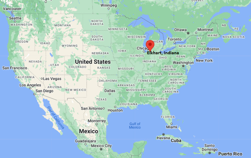
Elkhart Map, Indiana, USA
Where is Elkhart?: The Google Map showing the location of Elkhart in the U.S. state of Indiana.
Where is Elkhart Located?
Elkhart is a city located in the Elkhart County of Indiana, United States. Elkhart lies between 38.7431 Degrees North latitudes and 94.8255 Degrees West longitudes. According to 2020 U.S.census, the population of Elkhart city is 53923 people and the city has a total area of 27.51 sq mi. The city has numerous parks and recreational facilities.
Most Viewed US Maps
| USA Sttae Map | USA Region Map | USA Road Map |
| USA County Map | Where is USA in World Map? | US ZIP Code Map |
| USA Time Zones Map | US State and Capitals Map | USA Physical Map |
Find 4,400+ U.S. Cities by State - Explore Their Locations and Get Detailed Information
Elkhart, Indiana Quick Facts
| Property | Details |
|---|---|
| City | Elkhart |
| County | Elkhart County |
| State | Indiana |
| State Capital | Indianapolis |
| US Region | Midwest |
| Latitude | 41.6819°N |
| Longitude | 85.9767°W |
| Elevation | 748 ft (228 m) |
| Land Area | 25.95 sq mi |
| Water Area | 0.57 sq mi |
| Total Area | 26.52 sq mi |
| Population (2020 Census) | 53,923 |
| Population Density | Approximately 2,078 per sq mi |
| ZIP Codes | 46514, 46516, 46517 |
| Area Code | 574 |
| Time Zone Standard | Eastern Standard Time (EST), UTC−5 |
| Time Zone Daylight | Eastern Daylight Time (EDT), UTC−4 |
| Currency | US Dollar (USD) |
| FIPS Code | 18-20728 |
| Congressional District | Indiana's 2nd Congressional District |
Nearby Cities to Elkhart, Indiana
- Mishawaka, Indiana - West - 15 mi
- Goshen, Indiana - Southeast - 11 mi
- Bristol, Indiana - Northeast - 10 mi
- Niles, Michigan - Northwest - 18 mi
- Granger, Indiana - West - 14 mi
- Middlebury, Indiana - East - 18 mi
- South Bend, Indiana - West - 19 mi
- Plymouth, Indiana - Southwest - 31 mi
- Warsaw, Indiana - Southeast - 41 mi
- Benton Harbor, Michigan - Northwest - 52 mi
Elkhart, Indiana Climate and Weather Overview
| Month | Avg High (°F) | Avg Low (°F) | Avg Rainfall (in) |
|---|---|---|---|
| January | 31 | 18 | 2.30 |
| April | 58 | 38 | 3.60 |
| July | 82 | 63 | 3.90 |
| October | 61 | 43 | 2.80 |
| Annual | 58 | 41 | 38.10 |
| Climate Attribute | Details |
|---|---|
| Climate Classification (Köppen) | Hot-Summer Humid Continental (Dfa) |
| Annual Rainfall | Approximately 38 inches |
| Annual Sunshine Days | About 184 days |
| Hurricane/Tornado Risk | Very low hurricane risk; low to moderate tornado risk |
| Snowfall | Approximately 65 inches annually |
Driving Distances from Elkhart, Indiana
| City | State | Distance (mi) | Approx. Drive Time |
|---|---|---|---|
| Bristol | Indiana | 10 | 15 min |
| Goshen | Indiana | 11 | 18 min |
| Granger | Indiana | 14 | 20 min |
| Mishawaka | Indiana | 15 | 20 min |
| Middlebury | Indiana | 18 | 25 min |
| Niles | Michigan | 18 | 25 min |
| South Bend | Indiana | 19 | 30 min |
| Plymouth | Indiana | 31 | 40 min |
| Warsaw | Indiana | 41 | 50 min |
| Fort Wayne | Indiana | 86 | 1 hr 25 min |
Transportation and Connectivity in Elkhart, Indiana
| Transportation | Details |
|---|---|
| Airport Name | Elkhart Municipal Airport |
| IATA Code | EKI |
| Port | None |
| Major Highways | Interstate 80/90 (Indiana Toll Road), U.S. Highway 20, State Road 19, State Road 120 |
| Train/Amtrak Service | Amtrak Lake Shore Limited and Capitol Limited (Elkhart Station) |
| Local Bus/Transit Service | Interurban Trolley |
- Interstate 80/90 (Indiana Toll Road) provides regional access to Chicago, Toledo, and the eastern United States.
- U.S. Highway 20 is the primary east-west route through Elkhart, connecting the city with South Bend and northeastern Indiana.
- State Road 19 links Elkhart with Nappanee and other communities in northern Indiana.
- Amtrak's Lake Shore Limited and Capitol Limited stop at Elkhart Station, providing passenger rail service between Chicago and the East Coast.
Places to Visit in Elkhart, Indiana
| Landmark Name | Type |
|---|---|
| Wellfield Botanic Gardens | Botanical Garden |
| RV/MH Hall of Fame & Museum | Museum |
| National New York Central Railroad Museum | Railroad Museum |
| Midwest Museum of American Art | Art Museum |
| NIBCO Water & Ice Park | Recreation Park |
| Linton's Enchanted Gardens | Garden Center |
| Island Park | City Park |
| Ruthmere Museum | Historic House Museum |
| Elkhart Environmental Center | Nature Center |
| Hall of Heroes Super Hero Museum | Specialty Museum |
Colleges and Universities in Elkhart, Indiana
| Institution Name | Type | Level | Notable For |
|---|---|---|---|
| Indiana University South Bend – Elkhart Center | Public | University Center | Undergraduate and graduate degree programs |
| Ivy Tech Community College – Elkhart Campus | Public | Community College | Career training and transfer education |
| Goshen College | Private | College | Liberal arts and nursing programs |
| Bethel University | Private | University | Business, education, and ministry studies |
| Holy Cross College | Private | College | Liberal arts education |
| University of Notre Dame | Private | University | Research and nationally recognized academics |
| Purdue Polytechnic Institute – South Bend | Public | University | Technology and engineering education |
| Elkhart Community Schools | Public | K–12 District | Public education |
Waterbodies in Elkhart, Indiana
St. Joseph River, Elkhart River, Christiana Creek, Simonton Lake, Heaton Lake, Baldwin Lake, Cobus Creek, Baugo Bay
Golf Courses in Elkhart, Indiana
Bent Oak Golf Club, Meadow Valley Golf Club, Christiana Creek Country Club, Black Squirrel Golf Club, Elcona Country Club, Maplecrest Country Club, Knollwood Country Club, Warren Golf Course
Elkhart, Indiana — Key Historical Facts
- Elkhart was founded in 1832 and developed rapidly because of its strategic location where the St. Joseph and Elkhart rivers meet.
- The arrival of the Michigan Southern Railroad in the mid-19th century transformed Elkhart into a major manufacturing and transportation center.
- By the early 20th century, the city became known for producing musical instruments, including band instruments manufactured by several nationally recognized companies.
- After World War II, Elkhart emerged as the "RV Capital of the World," becoming the center of the recreational vehicle manufacturing industry.
- The city's economy expanded through advanced manufacturing, transportation, healthcare, and logistics while maintaining its leadership in RV production.
- Today, Elkhart is recognized for its manufacturing heritage, vibrant arts community, museums, riverfront parks, and its important role in northern Indiana's economy.
References
Indiana Related Maps and Info
- Where is Anderson
- Where is Auburn
- Where is Avon
- Where is Bedford
- Where is Beech Grove
- Where is Bluffton
- Where is Bloomington
- Where is Brownsburg
- Where is Carmel
- Where is Clarksville
- Where is Connersville
- Where is Crawfordsville
- Where is Crown Point
- Where is East Chicago
- Where is Elkhart
- Where is Evansville
- Where is Frankfort
- Where is Franklin
- Where is Gary
- Where is Goshen
- Where is Granger
- Where is Greencastle
- Where is Greenfield
- Where is Greensburg
- Where is Greenwood
- Where is Hammond
- Where is Highland
- Where is Hobart
- Where is Huntington
- Where is Jasper
- Where is Jeffersonville
- Where is Kendallville
- Where is Kokomo
- Where is La Porte
- Where is Lafayette
- Where is Lake Station
- Where is Lawrence
- Where is Lebanon
- Where is Logansport
- Where is Madison
- Where is Marion
- Where is Martinsville
- Where is Merrillville
- Where is Michigan City
- Where is Mishawaka
- Where is Muncie
- Where is Munster
- Where is New Albany
- Where is New Castle
- Where is New Haven
- Where is Noblesville
- Where is Peru
- Where is Plainfield
- Where is Plymouth
- Where is Portage
- Where is Schererville
- Where is Seymour
- Where is Shelbyville
- Where is South Bend
- Where is St. John
- Where is Terre Haute
- Where is Valparaiso
- Where is Vincennes
- Where is Warsaw
- Where is Washington
- Where is West Lafayette
- Where is Zionsville