
Where is Greenfield Located? - Greenfield is a city located in the Hancock County of Indiana, United States. Greenfield lies between 38.0501 Degrees North latitudes and 85.5458 Degrees West longitudes.
Location Map of Greenfield, Indiana
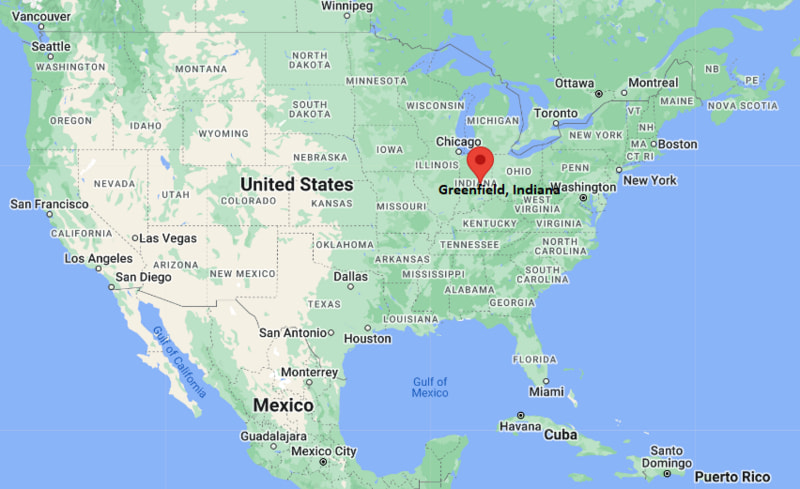
Greenfield Map, Indiana, USA
Where is Greenfield?: The Google Map showing the location of Greenfield in the U.S. state of Indiana.
Where is Greenfield Located?
Greenfield is a city located in the Hancock County of Indiana, United States. Greenfield lies between 38.0501 Degrees North latitudes and 85.5458 Degrees West longitudes. According to 2020 U.S.census, the population of Greenfield city is 23488 people and the city has a total area of 13.56 sq mi. The city has numerous parks and recreational facilities.
Most Viewed US Maps
| USA Sttae Map | USA Region Map | USA Road Map |
| USA County Map | Where is USA in World Map? | US ZIP Code Map |
| USA Time Zones Map | US State and Capitals Map | USA Physical Map |
Find 4,400+ U.S. Cities by State - Explore Their Locations and Get Detailed Information
Greenfield, Indiana Quick Facts
| Property | Information |
|---|---|
| City | Greenfield |
| County | Hancock County |
| State | Indiana |
| State Capital | Indianapolis |
| US Region | Midwestern United States |
| Latitude | 39.7850°N |
| Longitude | 85.7694°W |
| Elevation | 922 ft (281 m) |
| Land Area | 12.58 sq mi |
| Water Area | 0.03 sq mi |
| Total Area | 12.61 sq mi |
| Population (latest Census year) | 23,488 (Census 2020) |
| Population Density (per sq mi) | Approximately 1,868 |
| ZIP Codes | 46140 |
| Area Code | 317 |
| Time Zone Standard | Eastern Standard Time (EST, UTC−5) |
| Time Zone Daylight | Eastern Daylight Time (EDT, UTC−4) |
| Currency | United States Dollar (USD) |
| FIPS Code | 18-29394 |
| Congressional District | Indiana's 6th Congressional District |
Nearby Cities to Greenfield, Indiana
- Fortville, Indiana — 10 mi Northwest
- New Palestine, Indiana — 10 mi Southwest
- McCordsville, Indiana — 14 mi Northwest
- Lawrence, Indiana — 20 mi West
- Indianapolis, Indiana — 25 mi West
- Anderson, Indiana — 30 mi North
- Shelbyville, Indiana — 30 mi South
- Muncie, Indiana — 45 mi Northeast
- Bloomington, Indiana — 75 mi Southwest
- Lafayette, Indiana — 90 mi Northwest
Driving Distances from Greenfield, Indiana
| City | State | Distance (mi) | Approx. Drive Time |
|---|---|---|---|
| Fortville | Indiana | 10 | 15 minutes |
| New Palestine | Indiana | 10 | 15 minutes |
| McCordsville | Indiana | 14 | 20 minutes |
| Lawrence | Indiana | 20 | 30 minutes |
| Indianapolis | Indiana | 25 | 35 minutes |
| Anderson | Indiana | 30 | 45 minutes |
| Shelbyville | Indiana | 30 | 40 minutes |
| Muncie | Indiana | 45 | 1 hour |
| Bloomington | Indiana | 75 | 1 hour 30 minutes |
| Lafayette | Indiana | 90 | 1 hour 45 minutes |
Transportation and Connectivity in Greenfield, Indiana
| Transportation | Details |
|---|---|
| Airport Name | Indianapolis International Airport |
| IATA Code | IND |
| Port | Not Applicable |
| Major Highways | Interstate 70, U.S. Route 40, State Road 9 |
| Train/Amtrak Service | Nearest Amtrak service available in Indianapolis |
| Local Bus/Transit Service | Regional transportation services available |
- Interstate 70 - Major east-west interstate connecting Greenfield with Indianapolis and eastern Indiana.
- U.S. Route 40 - Historic National Road providing regional access across Indiana.
- State Road 9 - Important north-south route connecting Hancock County communities.
What are top Places to Visit in Greenfield, Indiana
| Landmark Name | Type |
|---|---|
| James Whitcomb Riley Boyhood Home and Museum | Historic Site |
| Hancock County Historical Society Museum | Museum |
| Riley Park | City Park |
| Pennsey Trail | Recreation Trail |
| Brandywine Creek Farms | Farm Attraction |
| Greenfield Veterans Memorial | Memorial |
| Hancock County Courthouse | Historic Landmark |
| Beckenholdt Family Park | Park |
| Greenfield Main Street Historic Area | Historic District |
| Nameless Creek Camp | Outdoor Recreation Area |
Colleges and Universities near Greenfield, Indiana
| Institution Name | Type | Level | Notable For |
|---|---|---|---|
| Ivy Tech Community College - Indianapolis Campus | Public | Community College | Technical education, workforce training, and associate degrees |
| University of Indianapolis | Private | University | Health sciences, business, education, and liberal arts |
| Indiana University-Purdue University Indianapolis (IUPUI) | Public | University | Research, healthcare, engineering, and professional programs |
| Ball State University | Public | University | Education, architecture, communications, and sciences |
| Greenfield-Central Community School Corporation | Public | K–12 District | Public education services |
Waterbodies in Greenfield, Indiana
Brandywine Creek, Sugar Creek, Blue River, Geist Reservoir, and nearby central Indiana waterways
Golf Courses near Greenfield, Indiana
Hawks Tail Golf Course, Royal Hylands Golf Club, Old Oakland Golf Club, and Links at Heartland Crossing
Greenfield, Indiana — Key Historical Facts
- Greenfield was founded in 1828 and became the county seat of Hancock County.
- The city was named Greenfield because of the area's fertile farmland and green landscape.
- Greenfield developed as an agricultural and trading center along the historic National Road.
- The arrival of railroads in the nineteenth century helped expand commerce and transportation in the community.
- Greenfield is the birthplace and longtime home area of poet James Whitcomb Riley, known as the "Hoosier Poet."
- The city's historic downtown and courthouse square preserve important examples of nineteenth-century architecture.
- Today, Greenfield is known for its small-town character, historic attractions, manufacturing, agriculture, and connection to the Indianapolis metropolitan area.
References
Indiana Related Maps and Info
- Where is Anderson
- Where is Auburn
- Where is Avon
- Where is Bedford
- Where is Beech Grove
- Where is Bluffton
- Where is Bloomington
- Where is Brownsburg
- Where is Carmel
- Where is Clarksville
- Where is Connersville
- Where is Crawfordsville
- Where is Crown Point
- Where is East Chicago
- Where is Elkhart
- Where is Evansville
- Where is Frankfort
- Where is Franklin
- Where is Gary
- Where is Goshen
- Where is Granger
- Where is Greencastle
- Where is Greenfield
- Where is Greensburg
- Where is Greenwood
- Where is Hammond
- Where is Highland
- Where is Hobart
- Where is Huntington
- Where is Jasper
- Where is Jeffersonville
- Where is Kendallville
- Where is Kokomo
- Where is La Porte
- Where is Lafayette
- Where is Lake Station
- Where is Lawrence
- Where is Lebanon
- Where is Logansport
- Where is Madison
- Where is Marion
- Where is Martinsville
- Where is Merrillville
- Where is Michigan City
- Where is Mishawaka
- Where is Muncie
- Where is Munster
- Where is New Albany
- Where is New Castle
- Where is New Haven
- Where is Noblesville
- Where is Peru
- Where is Plainfield
- Where is Plymouth
- Where is Portage
- Where is Schererville
- Where is Seymour
- Where is Shelbyville
- Where is South Bend
- Where is St. John
- Where is Terre Haute
- Where is Valparaiso
- Where is Vincennes
- Where is Warsaw
- Where is Washington
- Where is West Lafayette
- Where is Zionsville