
Where is St. John Located? - St. John is a city located in the Rolette County of Indiana, United States. St. John lies between 37.5687 Degrees North latitudes and 84.2963 Degrees West longitudes.
Location Map of St. John, Indiana
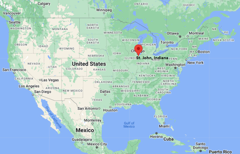
St. John Map, Indiana, USA
Where is St. John?: The Google Map showing the location of St. John in the U.S. state of Indiana.
Where is St. John Located?
St. John is a city located in the Indiana. If referring to St. John, the correct county is Lake County of Indiana, United States.. St. John lies between 37.5687 Degrees North latitudes and 84.2963 Degrees West longitudes. According to 2020 U.S.census, the population of St. John city is 20303 people and the city has a total area of 12.45 sq mi. The city has numerous parks and recreational facilities.
Most Viewed US Maps
| USA Sttae Map | USA Region Map | USA Road Map |
| USA County Map | Where is USA in World Map? | US ZIP Code Map |
| USA Time Zones Map | US State and Capitals Map | USA Physical Map |
Find 4,400+ U.S. Cities by State - Explore Their Locations and Get Detailed Information
St. John, Indiana Quick Facts
| Attribute | Details |
|---|---|
| Town | St. John |
| County | Lake County |
| State | Indiana |
| State Capital | Indianapolis |
| US Region | Midwestern United States |
| Latitude | 41.4500° N |
| Longitude | 87.4700° W |
| Elevation | Approximately 715 ft (218 m) |
| Land Area (sq mi) | 11.90 |
| Water Area (sq mi) | 0.01 |
| Total Area (sq mi) | 11.91 |
| Population (2020 Census) | 20,303 |
| Population Density (per sq mi) | 1,706.1 |
| ZIP Code | 46373 |
| Area Code | 219 |
| Time Zone Standard | Central Standard Time (CST), UTC−6 |
| Time Zone Daylight | Central Daylight Time (CDT), UTC−5 |
| Currency | United States Dollar (USD) |
| FIPS Code | 1868460 |
| Congressional District | 2nd Congressional District |
Transportation and Connectivity in St. John
| Transportation Feature | Details |
|---|---|
| Airport Name | Chicago Midway International Airport and Chicago O'Hare International Airport provide major commercial air service. |
| IATA Code | MDW, ORD |
| Port | Nearby Lake Michigan ports provide regional shipping access. |
| Major Highways | U.S. Highway 41, Interstate 65, Interstate 80/94, and U.S. Highway 231 |
| Train/Amtrak Service | Amtrak service is available from nearby Dyer and Chicago stations. |
| Local Bus/Transit Service | Regional bus services operate throughout Lake County and Northwest Indiana. |
- St. John is a town located in Lake County, Indiana.
- The town is located in the northwest corner of Indiana near the Illinois border and the Chicago metropolitan area.
- St. John is known for its suburban neighborhoods, parks, schools, and family-oriented community.
- The town has experienced significant population growth due to its location near Chicago and regional employment centers.
Top Places to Visit in St. John, Indiana
| Landmark Name | Type |
|---|---|
| Community Park | Public Park |
| Heartland Park | Recreation Area |
| Heritage Park | Community Park |
| St. John Town Center | Shopping and Community Area |
| Lake Hills Park | Neighborhood Park |
| John Friend Field | Sports Facility |
| Crown Point Historic District | Historic Area |
| Deep River Waterpark | Water Recreation Park |
| Indiana Dunes National Park | National Park |
| Lake Michigan Shoreline | Natural Recreation Area |
Driving Distances from St. John, Indiana to Nearby Cities
| City | State | Distance (mi) | Approx. Drive Time |
|---|---|---|---|
| Chicago | Illinois | 35 | 45 min |
| Gary | Indiana | 25 | 35 min |
| Crown Point | Indiana | 8 | 15 min |
| Valparaiso | Indiana | 35 | 45 min |
| South Bend | Indiana | 95 | 1 hr 40 min |
| Lafayette | Indiana | 120 | 2 hr |
| Fort Wayne | Indiana | 150 | 2 hr 30 min |
| Indianapolis | Indiana | 170 | 2 hr 45 min |
| Milwaukee | Wisconsin | 110 | 2 hr |
| Detroit | Michigan | 270 | 4 hr |
Colleges and Universities near St. John, Indiana
| Institution Name | Type | Level | Notable For |
|---|---|---|---|
| Purdue University Northwest | Public | University | Engineering, business, technology, and health sciences programs |
| Indiana University Northwest | Public | University | Business, education, healthcare, and liberal arts programs |
| Valparaiso University | Private | University | Engineering, nursing, business, and undergraduate programs |
| Calumet College of St. Joseph | Private | College | Liberal arts, business, education, and professional programs |
| Governors State University | Public | University | Education, business, health sciences, and graduate programs |
Waterbodies near St. John, Indiana
Lake Michigan, Cedar Lake, Deep River, Turkey Creek, and nearby Northwest Indiana waterways
Golf Courses near St. John, Indiana
Oak Knoll Golf Course, Wedgewood Brewing Company Golf Course area, Palmira Golf & Country Club, and nearby Northwest Indiana golf facilities
Key Landmarks and Places to Visit in St. John, Indiana
| Landmark Name | Type |
|---|---|
| Community Park | Public Park |
| Heartland Park | Recreation Area |
| Heritage Park | Community Park |
| John Friend Field | Sports Facility |
| Deep River Waterpark | Water Recreation Park |
| Indiana Dunes National Park | National Park |
| Lake Michigan Shoreline | Natural Recreation Area |
| Crown Point Historic District | Historic Area |
| Lake County Fairgrounds | Event Venue |
| South Shore Line | Regional Transportation Landmark |
Waterbodies near St. John, Indiana
Lake Michigan, Cedar Lake, Deep River, Turkey Creek, and nearby Northwest Indiana waterways
Golf Courses near St. John, Indiana
Oak Knoll Golf Course, Palmira Golf & Country Club, Wedgewood Golf Course, and nearby Northwest Indiana golf facilities
St. John, Indiana — Key Historical Facts
- St. John was settled in the mid-19th century by German Catholic immigrants who established farms and communities in the area.
- The town was named after Saint John the Baptist and grew from an agricultural settlement into a suburban community.
- Farming remained an important part of the local economy before residential development expanded in the late 20th century.
- St. John became one of the fastest-growing communities in Northwest Indiana due to its proximity to Chicago and regional transportation routes.
- Today, St. John is known for its parks, schools, suburban neighborhoods, and strong connection to the greater Chicago metropolitan area.
References
- Town of St. John Official Website
- Lake County Government
- U.S. Census Bureau
- Visit Indiana Tourism
- Indiana Dunes National Park
- Purdue University Northwest
Indiana Related Maps and Info
- Where is Anderson
- Where is Auburn
- Where is Avon
- Where is Bedford
- Where is Beech Grove
- Where is Bluffton
- Where is Bloomington
- Where is Brownsburg
- Where is Carmel
- Where is Clarksville
- Where is Connersville
- Where is Crawfordsville
- Where is Crown Point
- Where is East Chicago
- Where is Elkhart
- Where is Evansville
- Where is Frankfort
- Where is Franklin
- Where is Gary
- Where is Goshen
- Where is Granger
- Where is Greencastle
- Where is Greenfield
- Where is Greensburg
- Where is Greenwood
- Where is Hammond
- Where is Highland
- Where is Hobart
- Where is Huntington
- Where is Jasper
- Where is Jeffersonville
- Where is Kendallville
- Where is Kokomo
- Where is La Porte
- Where is Lafayette
- Where is Lake Station
- Where is Lawrence
- Where is Lebanon
- Where is Logansport
- Where is Madison
- Where is Marion
- Where is Martinsville
- Where is Merrillville
- Where is Michigan City
- Where is Mishawaka
- Where is Muncie
- Where is Munster
- Where is New Albany
- Where is New Castle
- Where is New Haven
- Where is Noblesville
- Where is Peru
- Where is Plainfield
- Where is Plymouth
- Where is Portage
- Where is Schererville
- Where is Seymour
- Where is Shelbyville
- Where is South Bend
- Where is St. John
- Where is Terre Haute
- Where is Valparaiso
- Where is Vincennes
- Where is Warsaw
- Where is Washington
- Where is West Lafayette
- Where is Zionsville