
Lexington is a city in central North Carolina and part of the Piedmont Triad region. Located about 20 miles south of Winston-Salem, it is known as the Barbecue Capital of the World for its long tradition of Lexington-style barbecue. The city also features historic neighborhoods, downtown shops, wineries, and nearby attractions across Davidson County.
Location Map of Lexington, Davidson County, North Carolina
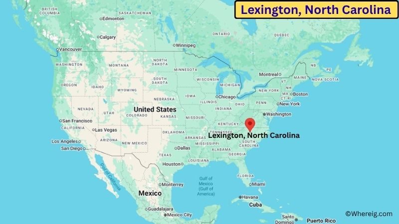
About Map: The map shows the location of Lexington in Davidson County, in the U.S. state of North Carolina.
Lexington Map, North Carolina
About Lexington Map: The Google Map highlights the location of Lexington in Davidson County, North Carolina. Use the zoom, satellite, and street-view options to explore the city's neighborhoods, roads, and nearby places.
Where is Lexington Located?
Lexington is a city located in Davidson County, North Carolina, the United States. It lies in the central Piedmont region, about 20 miles south of Winston-Salem and roughly 25 miles southwest of Greensboro. The city is located at approximately 35.824° North latitude and 80.253° West longitude. The 2020 Census recorded 19,632 residents, and Lexington covers about 18.96 square miles (49.11 sq km). The community was founded in the 18th century and became the county seat of Davidson County. Lexington grew as a center for agriculture, furniture manufacturing, textiles, and transportation. The city is especially famous for Lexington-style barbecue, a regional tradition based on slow-cooked pork and a vinegar-based sauce. Its barbecue heritage has made Lexington a major food destination in central North Carolina. One of the city's best-known landmarks is the historic Davidson County Courthouse in downtown Lexington. The Uptown Lexington area contains historic buildings, local restaurants, shops, public art, and community spaces. Nearby Childress Vineyards adds a connection to the Yadkin Valley wine region. A unique feature of Lexington is its strong barbecue identity, reflected in the annual Lexington Barbecue Festival. Interstate 85 and U.S. Highway 64 provide convenient connections to Greensboro, Winston-Salem, High Point, Charlotte, and other Piedmont communities.
Most Viewed US Maps
| USA Sttae Map | USA Region Map | USA Road Map |
| USA County Map | Where is USA in World Map? | US ZIP Code Map |
| USA Time Zones Map | US State and Capitals Map | USA Physical Map |
Find 4,400+ U.S. Cities by State - Explore Their Locations and Get Detailed Information
Lexington City Facts
| City | Lexington |
| State | North Carolina |
| County | Davidson County |
| Country | United States |
| Region | North Carolina Piedmont / Piedmont Triad |
| Incorporated | 1828 |
| Founded | 1775 |
| Total Area | 18.96 sq mi (49.11 sq km) |
| Land Area | 18.89 sq mi (48.92 sq km) |
| Water Area | 0.07 sq mi (0.18 sq km) |
| Elevation | About 800 ft (244 m) |
| Population (2023 estimate) | About 19,500 |
| Population (2020 Census) | 19,632 |
| Population Density | About 1,039 people per sq mi |
| Time Zone | Eastern Time (ET) |
| ZIP Codes | 27292, 27295, 27296 |
| Area Code | 336, 743 |
| Major Highways | Interstate 85, U.S. Highway 64, U.S. Highway 29 |
| Public Transit | Lexington Transit System |
| Major Attractions | Uptown Lexington, Davidson County Historical Museum, Lexington Barbecue Festival, Childress Vineyards |
| Official Website | https://www.lexingtonnc.gov/ |
Distance from Lexington, NC to Nearby Cities
- Thomasville, NC – 10 miles (16 km)
- Welcome, NC – 8 miles (13 km)
- High Point, NC – 15 miles (24 km)
- Winston-Salem, NC – 20 miles (32 km)
- Archdale, NC – 15 miles (24 km)
- Greensboro, NC – 25 miles (40 km)
- Asheboro, NC – 25 miles (40 km)
- Mocksville, NC – 25 miles (40 km)
- Salisbury, NC – 30 miles (48 km)
- Statesville, NC – 40 miles (64 km)
- Concord, NC – 55 miles (89 km)
- Charlotte, NC – 65 miles (105 km)
- Mount Airy, NC – 55 miles (89 km)
- Burlington, NC – 40 miles (64 km)
- Raleigh, NC – 100 miles (161 km)
Top Attractions in Lexington
- Uptown Lexington – The city's historic downtown area with restaurants, shops, public art, historic buildings, and community events.
- Davidson County Historical Museum – A local museum housed in the historic courthouse complex and focused on Davidson County history.
- Lexington Barbecue Festival – An annual October event celebrating the city's famous Lexington-style barbecue tradition.
- Childress Vineyards – A nearby winery in the Yadkin Valley region offering wine tastings, tours, events, and vineyard views.
- Finch Park – A large community park with walking trails, sports facilities, playgrounds, picnic areas, and a lake.
- Lexington Memorial Hospital Historic District – A local historic area reflecting the city's architectural and civic development.
- North Carolina Vietnam Veterans Memorial – A nearby memorial honoring North Carolina residents who served and died during the Vietnam War.
- Boone's Cave Park – A nearby natural area along the Yadkin River with hiking trails, forests, camping, and a historic cave.
Airports Near Lexington
- Piedmont Triad International Airport (GSO) – 35 miles
- Smith Reynolds Airport (INT) – 25 miles
- Davidson County Airport (EXX) – 15 miles
- Charlotte Douglas International Airport (CLT) – 70 miles
- Raleigh-Durham International Airport (RDU) – 105 miles
Sources:
Population and area data sourced from the United States Census Bureau (2020 Census). General city information referenced from the official Lexington city website and local government records.
North Carolina Maps and Info
- Where is Albemarle
- Where is Apex
- Where is Asheboro
- Where is Asheville
- Where is Belmont
- Where is Boone
- Where is Burlington
- Where is Carrboro
- Where is Cary
- Where is Chapel Hill
- Where is Clayton
- Where is Clemmons
- Where is Concord
- Where is Cornelius
- Where is Davidson
- Where is Eden
- Where is Elizabeth City
- Where is Fuquay-Varina
- Where is Garner
- Where is Gastonia
- Where is Goldsboro
- Where is Graham
- Where is Greenville
- Where is Harrisburg
- Where is Havelock
- Where is Hendersonville
- Where is Hickory
- Where is High Point
- Where is Holly Springs
- Where is Hope Mills
- Where is Huntersville
- Where is Indian Trail
- Where is Kannapolis
- Where is Kernersville
- Where is Kinston
- Where is Knightdale
- Where is Laurinburg
- Where is Leland
- Where is Lenoir
- Where is Lumberton
- Where is Matthews
- Where is Mebane
- Where is Mint Hill
- Where is Monroe
- Where is Mooresville
- Where is Morganton
- Where is Morrisville
- Where is Mount Holly
- Where is Murraysville
- Where is New Bern
- Where is Pinehurst
- Where is Piney Green
- Where is Reidsville
- Where is Roanoke Rapids
- Where is Rocky Mount
- Where is Salisbury
- Where is Sanford
- Where is Shelby
- Where is Southern Pines
- Where is Stallings
- Where is Statesville
- Where is Thomasville
- Where is Wake Forest
- Where is Waxhaw
- Where is Wilmington
- Where is Wilson
- Where is Winston-Salem