
Monett is a city in southwest Missouri, located in Barry and Lawrence counties near the Arkansas border. It sits about 45 miles southwest of Springfield and serves as a regional center for the surrounding Ozark communities. The city developed as a railroad and agricultural hub and is known for its historic downtown, local parks, and proximity to the scenic landscapes of the Ozarks.
Location Map of Monett, Barry County, Missouri
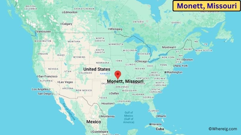
About Map: The map shows the location of Monett in Barry County, in the U.S. state of Missouri.
Monett Map, Missouri
About Monett Map: The Google Map highlights the location of Monett in Barry County, Missouri. Use the zoom, satellite, and street-view options to explore the city's neighborhoods, roads, and nearby places.
Where is Monett Located?
Monett is a city located in Barry County and Lawrence County, Missouri, the United States. It lies in southwest Missouri, about 45 miles southwest of Springfield and about 20 miles east of the Missouri-Oklahoma border. Neosho is roughly 35 miles west, while Joplin is about 45 miles northwest. Monett is positioned near 36.928° North latitude and 93.927° West longitude. The 2020 Census recorded 9,227 residents. The city covers about 8.61 square miles, or 22.30 square kilometers, of land. Monett's development was strongly influenced by the railroad, which connected the community with larger markets and helped agriculture and local industry grow. The city's historic downtown reflects this past. A unique fact about Monett is that its city limits extend into both Barry and Lawrence counties, making it one of the communities in Missouri that crosses a county boundary.
Most Viewed US Maps
| USA Sttae Map | USA Region Map | USA Road Map |
| USA County Map | Where is USA in World Map? | US ZIP Code Map |
| USA Time Zones Map | US State and Capitals Map | USA Physical Map |
Find 4,400+ U.S. Cities by State - Explore Their Locations and Get Detailed Information
Monett City Facts
| City | Monett |
| State | Missouri |
| County | Barry and Lawrence Counties |
| Country | United States |
| Region | Southwest Missouri |
| Incorporated | 1887 |
| Founded | 1870 |
| Total Area | 8.61 sq mi (22.30 sq km) |
| Land Area | 8.60 sq mi (22.27 sq km) |
| Water Area | 0.01 sq mi (0.03 sq km) |
| Elevation | 1,388 ft (423 m) |
| Population (2023 estimate) | About 9,000 |
| Population (2020 Census) | 9,227 |
| Population Density | 1,073 people per sq mi |
| Time Zone | Central Time (CST/CDT) |
| ZIP Codes | 65708 |
| Area Code | 417 |
| Major Highways | US-60, US-71, and MO-37 |
| Public Transit | Local and regional demand-response transportation services |
| Major Attractions | Monett Historical Society Museum, Monett City Park, downtown Monett, and nearby Ozark recreation areas |
| Official Website | https://www.monettmo.com/ |
Distance from Monett, MO to Nearby Cities
- Pierce City, MO – 8 miles (13 km)
- Purcell, MO – 11 miles (18 km)
- Mount Vernon, MO – 15 miles (24 km)
- Aurora, MO – 17 miles (27 km)
- Cassville, MO – 20 miles (32 km)
- Republic, MO – 31 miles (50 km)
- Neosho, MO – 35 miles (56 km)
- Carthage, MO – 38 miles (61 km)
- Springfield, MO – 45 miles (72 km)
- Joplin, MO – 45 miles (72 km)
- Branson, MO – 52 miles (84 km)
- Webb City, MO – 43 miles (69 km)
- Ozark, MO – 49 miles (79 km)
- Nixa, MO – 44 miles (71 km)
- Bolivar, MO – 54 miles (87 km)
- Fayetteville, AR – 67 miles (108 km)
- Rogers, AR – 71 miles (114 km)
- Fort Smith, AR – 118 miles (190 km)
Top Attractions in Monett, MO
- Monett Historical Society Museum – A local museum preserving the history of Monett and the surrounding communities.
- Monett City Park – A community park with open space, walking areas, sports facilities, and recreational amenities.
- Historic Downtown Monett – A traditional downtown area with historic buildings, local businesses, restaurants, and community spaces.
- Monett Area YMCA – A community recreation facility offering fitness, sports, swimming, and youth programs.
- Monett Municipal Pool – A seasonal public swimming facility serving residents and visitors.
- Roaring River State Park – A nearby state park known for trout fishing, hiking, springs, and wooded Ozark scenery.
- George Washington Carver National Monument – A national monument near Diamond that preserves the birthplace and early life story of George Washington Carver.
- Wilson's Creek National Battlefield – A historic Civil War battlefield located near Springfield, about 45 miles from Monett.
Airports Near Monett, MO
- Springfield-Branson National Airport (SGF) – 51 miles
- Joplin Regional Airport (JLN) – 50 miles
- Branson Airport (BKG) – 62 miles
- Northwest Arkansas National Airport (XNA) – 74 miles
- Neosho Hugh Robinson Airport (EOS) – 36 miles
Sources:
Population and area data sourced from the United States Census Bureau (2020 Census). General city information referenced from the official Monett city website and local government records.
Other Missouri Maps & Info
- Where is Affton
- Where is Arnold
- Where is Ballwin
- Where is Belton
- Where is Blue Springs
- Where is Cape Girardeau
- Where is Chesterfield
- Where is Clayton
- Where is Columbia
- Where is Concord
- Where is Creve Coeur
- Where is Farmington
- Where is Ferguson
- Where is Florissant
- Where is Gladstone
- Where is Grandview
- Where is Hazelwood
- Where is Independence
- Where is Jefferson City
- Where is Joplin
- Where is Kirksville
- Where is Kirkwood
- Where is Lake St. Louis
- Where is Lee's Summit
- Where is Liberty
- Where is Manchester
- Where is Maryland Heights
- Where is Mehlville
- Where is Nixa
- Where is O'Fallon
- Where is Oakville
- Where is Old Jamestown
- Where is Ozark
- Where is Raymore
- Where is Raytown
- Where is Republic
- Where is Rolla
- Where is Sedalia
- Where is Spanish Lake
- Where is St. Charles
- Where is St. Joseph
- Where is St. Louis
- Where is St. Peters
- Where is University City
- Where is Warrensburg
- Where is Webster Groves
- Where is Wentzville
- Where is Wildwood