
Richmond is a historic city in eastern Indiana and the county seat of Wayne County. It sits near the Ohio state line, about 70 miles east of Indianapolis and 40 miles west of Dayton, Ohio. The city is known for its historic downtown, Quaker heritage, Richmond Art Museum, and the scenic parks and trails around the Whitewater River.
Location Map of Richmond, Wayne County, Indiana
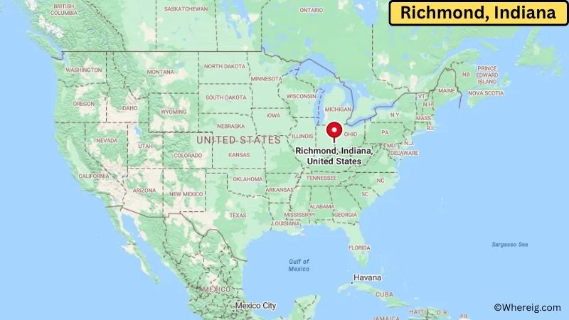
About Map: The map shows the location of Richmond in Wayne County, in the U.S. state of Indiana.
Richmond Map, Indiana
About Richmond Map: The Google Map highlights the location of Richmond in Wayne County, Indiana. Use the zoom, satellite, and street-view options to explore the city's neighborhoods, roads, and nearby places.
Where is Richmond Located?
Richmond is a city located in Wayne County, Indiana, the United States. It lies in eastern Indiana near the Ohio border, about 70 miles east of Indianapolis and roughly 40 miles west of Dayton, Ohio. Connersville is about 25 miles west, while Centerville is around 5 miles west of Richmond. The city is positioned near 39.829° North latitude and 84.891° West longitude. The 2020 Census recorded 35,720 residents. Richmond covers about 24.07 square miles, or 62.34 square kilometers. The city was founded in 1806 and incorporated in 1840. Richmond became an important center for Quaker settlement, education, publishing, manufacturing, and transportation during the 19th and 20th centuries. Earlham College, founded in 1859, remains one of the city's best-known institutions. The Richmond Art Museum, established in 1898, is one of the oldest art museums in Indiana. The city's historic districts contain many well-preserved homes and buildings from different periods of its development. A unique fact about Richmond is its strong Quaker heritage and its connection to the Underground Railroad, with several local sites associated with anti-slavery activity. The Whitewater River and nearby parks provide opportunities for walking, fishing, boating, and wildlife viewing. US-40, US-27, and Interstate 70 provide major road connections to Indianapolis, Dayton, Cincinnati, and other communities in Indiana and Ohio.
Most Viewed US Maps
| USA Sttae Map | USA Region Map | USA Road Map |
| USA County Map | Where is USA in World Map? | US ZIP Code Map |
| USA Time Zones Map | US State and Capitals Map | USA Physical Map |
Find 4,400+ U.S. Cities by State - Explore Their Locations and Get Detailed Information
Richmond City Facts
| City | Richmond |
| State | Indiana |
| County | Wayne County |
| Country | United States |
| Region | Eastern Indiana and Whitewater Valley |
| Incorporated | 1840 |
| Founded | 1806 |
| Total Area | 24.07 sq mi (62.34 sq km) |
| Land Area | 23.95 sq mi (62.03 sq km) |
| Water Area | 0.12 sq mi (0.31 sq km) |
| Elevation | 980 ft (299 m) |
| Population (2023 estimate) | About 35,500 |
| Population (2020 Census) | 35,720 |
| Population Density | 1,491 people per sq mi |
| Time Zone | Eastern Time (EST/EDT) |
| ZIP Codes | 47374, 47375, 47376 |
| Area Code | 765 |
| Major Highways | I-70, US-27, US-40, and US-35 |
| Public Transit | Roseview Transit |
| Major Attractions | Richmond Art Museum, Earlham College, Wayne County Historical Museum, Glen Miller Park, and Historic Richmond |
| Official Website | https://www.richmondindiana.gov/ |
Distance from Richmond, IN to Nearby Cities
- Centerville, IN – 5 miles (8 km)
- Cambridge City, IN – 12 miles (19 km)
- Hagerstown, IN – 15 miles (24 km)
- Connersville, IN – 25 miles (40 km)
- New Castle, IN – 30 miles (48 km)
- Greenville, OH – 25 miles (40 km)
- Oxford, OH – 30 miles (48 km)
- Anderson, IN – 45 miles (72 km)
- Muncie, IN – 45 miles (72 km)
- Dayton, OH – 40 miles (64 km)
- Hamilton, OH – 40 miles (64 km)
- Cincinnati, OH – 55 miles (89 km)
- Indianapolis, IN – 70 miles (113 km)
- Springfield, OH – 55 miles (89 km)
- Columbus, OH – 100 miles (161 km)
- Fort Wayne, IN – 100 miles (161 km)
- Bloomington, IN – 115 miles (185 km)
- Louisville, KY – 125 miles (201 km)
Top Attractions in Richmond
- Richmond Art Museum – One of Indiana's oldest art museums, featuring American art, regional works, and educational exhibitions.
- Earlham College – A historic liberal arts college founded by Quakers in 1859, with a scenic campus and important connection to Richmond's cultural history.
- Wayne County Historical Museum – A local museum preserving artifacts, photographs, documents, and exhibits about Richmond and Wayne County history.
- Historic Richmond – The city's historic neighborhoods feature preserved homes, churches, commercial buildings, and sites connected to Richmond's Quaker and architectural heritage.
- Glen Miller Park – A large city park with a lake, walking trails, gardens, playgrounds, picnic areas, and recreational facilities.
- Whitewater Gorge – A natural area near Richmond with wooded trails, ravines, limestone features, and opportunities for hiking and wildlife viewing.
- Joseph Moore Museum – A natural history museum at Earlham College featuring fossils, minerals, animals, and educational exhibits.
- Middlefork Reservoir – A nearby recreational area offering fishing, boating, hiking, and outdoor activities.
- Levi Coffin House – A historic Underground Railroad site in nearby Fountain City associated with the anti-slavery movement and escape of freedom seekers.
Airports Near Richmond, IN
- Richmond Municipal Airport (RID) – 5 miles
- Dayton International Airport (DAY) – 45 miles
- Cincinnati/Northern Kentucky International Airport (CVG) – 70 miles
- Indianapolis International Airport (IND) – 75 miles
- Delaware Municipal Airport (DLZ) – 75 miles
Sources:
Population and area data sourced from the United States Census Bureau (2020 Census). General city information referenced from the official Richmond city website and local government records.
Indiana Related Maps and Info
- Where is Anderson
- Where is Auburn
- Where is Avon
- Where is Bedford
- Where is Beech Grove
- Where is Bluffton
- Where is Bloomington
- Where is Brownsburg
- Where is Carmel
- Where is Clarksville
- Where is Connersville
- Where is Crawfordsville
- Where is Crown Point
- Where is East Chicago
- Where is Elkhart
- Where is Evansville
- Where is Frankfort
- Where is Franklin
- Where is Gary
- Where is Goshen
- Where is Granger
- Where is Greencastle
- Where is Greenfield
- Where is Greensburg
- Where is Greenwood
- Where is Hammond
- Where is Highland
- Where is Hobart
- Where is Huntington
- Where is Jasper
- Where is Jeffersonville
- Where is Kendallville
- Where is Kokomo
- Where is La Porte
- Where is Lafayette
- Where is Lake Station
- Where is Lawrence
- Where is Lebanon
- Where is Logansport
- Where is Madison
- Where is Marion
- Where is Martinsville
- Where is Merrillville
- Where is Michigan City
- Where is Mishawaka
- Where is Muncie
- Where is Munster
- Where is New Albany
- Where is New Castle
- Where is New Haven
- Where is Noblesville
- Where is Peru
- Where is Plainfield
- Where is Plymouth
- Where is Portage
- Where is Schererville
- Where is Seymour
- Where is Shelbyville
- Where is South Bend
- Where is St. John
- Where is Terre Haute
- Where is Valparaiso
- Where is Vincennes
- Where is Warsaw
- Where is Washington
- Where is West Lafayette
- Where is Zionsville