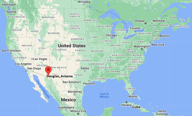
Where is Douglas Located? - Douglas is a city located in the Cochise County of Arizona, United States. Douglas lies between 33.2671 Degrees North latitudes and 93.2394 Degrees West longitudes.
Location Map of Douglas, Arizona
Douglas Map, Arizona, USA
Where is Douglas?: The Google Map showing the location of Douglas in the U.S. state of Arizona.
Where is Douglas Located?
Douglas is a city located in the Cochise County of Arizona, United States. Douglas lies between 33.2671 Degrees North latitudes and 93.2394 Degrees West longitudes. According to 2020 U.S.census, the population of Douglas city is 16534 people and the city has a total area of 9.98 sq mi. The city has numerous parks and recreational facilities.
Mountain Standard Time (MST), UTC -7 (no daylight saving time)
Currency
United States Dollar (USD)
FIPS Code
04-18820
Congressional District
Arizona's 6th Congressional District
Nearby Cities to Douglas, Arizona
Bisbee, Arizona - Northwest - 26 mi
Naco, Arizona - West - 28 mi
Huachuca City, Arizona - Northwest - 54 mi
Sierra Vista, Arizona - Northwest - 58 mi
Tombstone, Arizona - Northwest - 61 mi
Benson, Arizona - Northwest - 94 mi
Willcox, Arizona - North - 97 mi
Nogales, Arizona - West - 121 mi
Tucson, Arizona - Northwest - 120 mi
Safford, Arizona - North - 135 mi
Douglas, Arizona Climate and Weather Overview
Month
Avg High (°F)
Avg Low (°F)
Avg Rainfall (in)
January
64
32
0.6
April
81
46
0.3
July
92
68
3.0
October
82
49
1.1
Annual
80
49
13.5
Climate Attribute
Details
Climate Classification (Köppen)
Cold Semi-Arid (BSk)
Annual Rainfall
About 13.5 inches
Annual Sunshine Days
Approximately 290 days
Hurricane/Tornado Risk
No hurricane risk; very low tornado risk
Snowfall
About 2 inches annually
Driving Distances from Douglas, Arizona
City
State
Distance (mi)
Approx. Drive Time
Bisbee
Arizona
26
30 min
Naco
Arizona
28
35 min
Huachuca City
Arizona
54
1 hr
Sierra Vista
Arizona
58
1 hr
Tombstone
Arizona
61
1 hr 10 min
Benson
Arizona
94
1 hr 35 min
Willcox
Arizona
97
1 hr 40 min
Tucson
Arizona
120
2 hr
Nogales
Arizona
121
2 hr
Safford
Arizona
135
2 hr 30 min
Transportation and Connectivity in Douglas, Arizona
Transportation
Details
Airport Name
Bisbee Douglas International Airport
IATA Code
DUG
Port of Entry
Douglas Port of Entry (U.S.-Mexico Border)
Major Highways
US Highway 80, Arizona State Route 80, Arizona State Route 80 Business
Train/Passenger Rail
No passenger rail service
Local Bus/Transit Service
Regional transit and Cochise Connection services
US Highway 80 and Arizona State Route 80 connect Douglas with Bisbee, Sierra Vista, and Interstate 10.
The Douglas Port of Entry is one of Arizona's major international border crossings, linking the city with Agua Prieta, Sonora, Mexico.
Bisbee Douglas International Airport primarily serves general aviation, charter, and government operations.
Regional transportation services connect Douglas with other communities across Cochise County.
Key Landmarks and Places to Visit in Douglas, Arizona
Landmark Name
Type
Gadsden Hotel
Historic Hotel
Douglas Historic District
Historic District
Douglas-Williams House Museum
History Museum
Slaughter Ranch Museum
Historic Ranch
Douglas Visitor Center
Visitor Center
Cochise College - Douglas Center
Education Center
Copper Queen Plaza
Public Plaza
Leslie Canyon National Wildlife Refuge
Wildlife Refuge
Chiricahua National Monument
National Monument
Agua Prieta Border Crossing
International Port of Entry
Colleges and Universities in Douglas, Arizona
Institution Name
Type
Level
Notable For
Cochise College - Douglas Center
Public
Community College
Associate degrees, workforce training, and continuing education
Cochise College - Sierra Vista Campus
Public
Community College
Academic transfer and technical education
University of Arizona
Public
University
Research, engineering, agriculture, and health sciences
Northern Arizona University
Public
University
Teacher education and online degree programs
Arizona State University
Public
University
Business, engineering, and innovation
Waterbodies in Douglas, Arizona
Whitewater Draw, Leslie Creek, Greenbush Draw, Turkey Creek, San Bernardino River, Black Draw, Whitewater Draw Wildlife Area, San Pedro River (regional)
Golf Courses in Douglas, Arizona
Douglas Municipal Golf Course, Turquoise Valley Golf Course, Mountain View Golf Course, Pueblo del Sol Country Club, Cochise Golf & Country Club, Torres Blancas Golf Club
Douglas, Arizona - Key Historical Facts
Douglas was founded in 1901 as a company town to support the nearby Phelps Dodge copper smelter, one of the largest copper processing facilities in the Southwest.
The city was named after mining entrepreneur Dr. James Douglas, whose leadership helped expand Arizona's copper industry during the late 19th and early 20th centuries.
Its location on the United States-Mexico border made Douglas an important center for international trade, transportation, and customs operations.
During the early 1900s, the city experienced rapid growth as workers, merchants, and railroad companies supported the thriving mining economy.
Although copper smelting declined in the late 20th century, Douglas continued to grow through cross-border commerce, education, tourism, and government services.
Today, Douglas is known for its rich mining heritage, well-preserved historic architecture, vibrant border culture, and its role as an international gateway between Arizona and Sonora, Mexico.