
Where is New River Located? - New River is a city located in the Maricopa County of Arizona, United States. New River lies between 36.3401 Degrees North latitudes and 92.3852 Degrees West longitudes.
Location Map of New River, Arizona
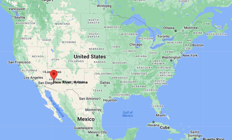
New River Map, Arizona, USA
Where is New River?: The Google Map showing the location of New River in the U.S. state of Arizona.
Where is New River Located?
New River is a city located in the Maricopa County of Arizona, United States. New River lies between 36.3401 Degrees North latitudes and 92.3852 Degrees West longitudes. According to 2020 U.S.census, the population of New River city is 17290 people and the city has a total area of 56.13 sq mi. The city has numerous parks and recreational facilities.
Most Viewed US Maps
| USA Sttae Map | USA Region Map | USA Road Map |
| USA County Map | Where is USA in World Map? | US ZIP Code Map |
| USA Time Zones Map | US State and Capitals Map | USA Physical Map |
Find 4,400+ U.S. Cities by State - Explore Their Locations and Get Detailed Information
New River, Arizona Quick Facts
| Attribute | Information |
|---|---|
| City | New River |
| County | Maricopa County |
| State | Arizona |
| State Capital | Phoenix |
| US Region | West (Mountain) |
| Latitude | 33.9151° N |
| Longitude | 112.1360° W |
| Elevation | 2,185 ft (666 m) |
| Land Area | 22.6 sq mi |
| Water Area | 0.0 sq mi |
| Total Area | 22.6 sq mi |
| Population (2020 Census) | 16,612 |
| Population Density | Approximately 735 per sq mi |
| ZIP Code | 85087 |
| Area Code | 623 |
| Time Zone Standard | Mountain Standard Time (MST, UTC−7) |
| Time Zone Daylight | Arizona does not observe Daylight Saving Time |
| Currency | United States Dollar (USD) |
| FIPS Code | 04-48920 |
| Congressional District | Arizona's 7th Congressional District |
Transportation and Connectivity in New River
| Category | Information |
|---|---|
| Airport Name | Phoenix Sky Harbor International Airport |
| IATA Code | PHX |
| Nearest General Aviation Airport | Phoenix Deer Valley Airport |
| Major Highways | Interstate 17, State Route 69, Carefree Highway |
| Rail Service | Freight rail service available in nearby Phoenix area |
| Public Transit | Regional transit connections through Valley Metro |
| Regional Connections | Phoenix metropolitan area access |
- New River is located along Interstate 17 north of Phoenix and provides access to the northern Phoenix metropolitan area.
- Interstate 17 connects the community with Phoenix, Flagstaff, and northern Arizona destinations.
- Carefree Highway provides east–west connections through northern Maricopa County.
- Phoenix Sky Harbor International Airport provides major domestic and international air service.
Top Places to Visit in New River, Arizona
| Landmark Name | Type |
|---|---|
| New River Trail | Hiking and Recreation Trail |
| Lake Pleasant Regional Park | Regional Park |
| Sonoran Preserve | Nature Preserve |
| Black Canyon Trail | Mountain Biking and Hiking Trail |
| Horseshoe Lake | Lake Recreation Area |
| Anthem Community Park | Community Park |
| Desert Foothills Scenic Areas | Natural Attraction |
| Bradshaw Mountains | Mountain Recreation Area |
| Ben Avery Shooting Facility | Outdoor Recreation Facility |
| Sonoran Desert National Monument | Desert Conservation Area |
Driving Distances from New River, Arizona to Nearby Cities
| City | State | Distance (mi) | Approx. Drive Time |
|---|---|---|---|
| Phoenix | Arizona | 35 | 40 minutes |
| Scottsdale | Arizona | 45 | 55 minutes |
| Glendale | Arizona | 30 | 35 minutes |
| Peoria | Arizona | 25 | 30 minutes |
| Tempe | Arizona | 55 | 1 hour |
| Flagstaff | Arizona | 125 | 2 hours |
| Prescott | Arizona | 95 | 1 hour 45 minutes |
| Tucson | Arizona | 170 | 2 hours 40 minutes |
| Las Vegas | Nevada | 300 | 4 hours 30 minutes |
| San Diego | California | 370 | 5 hours 30 minutes |
Colleges and Universities Near New River, Arizona
| Institution Name | Type | Level | Notable For |
|---|---|---|---|
| Arizona State University | Public | University | Research, business, engineering, sustainability, and sciences |
| Glendale Community College | Public | Community College | Associate degrees, workforce training, and transfer programs |
| Paradise Valley Community College | Public | Community College | Health sciences, business, arts, and general studies |
| DeVry University – Phoenix Campus | Private | University | Technology, business, and professional programs |
| Grand Canyon University | Private | University | Business, education, nursing, and online programs |
Waterbodies Near New River, Arizona
New River, Agua Fria River, Lake Pleasant, Cave Creek Wash, and nearby desert waterways of northern Maricopa County.
Stadiums and Sports Facilities in New River
Nearby Anthem Community Park sports facilities, Desert Mountain High School athletic facilities, Ben Avery Shooting Facility, and regional Phoenix-area recreation complexes.
New River, Arizona — Key Historical Facts
- The New River area has a long history connected to Native American communities that lived throughout the Sonoran Desert region.
- The community developed along the New River drainage area and the historic transportation routes of central Arizona.
- New River grew as a rural desert community before experiencing residential growth linked to the expansion of the Phoenix metropolitan area.
- The construction of Interstate 17 improved access between New River, Phoenix, and northern Arizona communities.
- The area's desert landscape, mountain views, and open spaces have influenced its modern residential character.
- Today, New River is recognized for its desert environment, outdoor recreation, equestrian properties, and proximity to Phoenix.
References
- Maricopa County Government
- U.S. Census Bureau
- Visit Arizona Tourism
- Arizona State Parks
- U.S. Forest Service
Arizona Related Links
- Where is Anthem
- Where is Apache Junction
- Where is Avondale
- Where is Benson
- Where is Bullhead City
- Where is Casa Grande
- Where is Casas Adobes
- Where is Catalina Foothills
- Where is Douglas
- Where is Drexel Heights
- Where is El Mirage
- Where is Eloy
- Where is Flagstaff
- Where is Florence
- Where is Flowing Wells
- Where is Fort Mohave
- Where is Fortuna Foothills
- Where is Fountain Hills
- Where is Glendale
- Where is Globe
- Where is Goodyear
- Where is Green Valley
- Where is Guadalupe
- Where is Kingman
- Where is Lake Havasu City
- Where is Litchfield Park
- Where is Marana
- Where is Maricopa
- Where is New River
- Where is Nogales
- Where is Oro Valley
- Where is Page
- Where is Payson
- Where is Peoria
- Where is Prescott
- Where is Prescott Valley
- Where is Queen Creek
- Where is Rio Rico
- Where is Sahuarita
- Where is San Luis
- Where is San Tan Valley
- Where is Sierra Vista
- Where is Snowflake
- Where is Sun City
- Where is Sun City West
- Where is Sun Lakes
- Where is Surprise
- Where is Tanque Verde
- Where is Tempe
- Where is Thatcher
- Where is Tolleson
- Where is Valencia West
- Where is Wickenburg
- Where is Youngtown
- Where is Yuma