
Where is Florence Located? - Florence is a city located in the Pinal County of Arizona, United States. Florence lies between 35.2438 Degrees North latitudes and 91.7364 Degrees West longitudes.
Location Map of Florence, Arizona
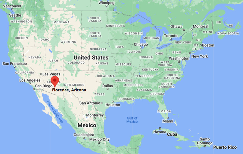
Florence Map, Arizona, USA
Where is Florence?: The Google Map showing the location of Florence in the U.S. state of Arizona.
Where is Florence Located?
Florence is a city located in the Pinal County of Arizona, United States. Florence lies between 35.2438 Degrees North latitudes and 91.7364 Degrees West longitudes. According to 2020 U.S.census, the population of Florence city is 26785 people and the city has a total area of 62.62 sq mi. The city has numerous parks and recreational facilities.
Most Viewed US Maps
| USA Sttae Map | USA Region Map | USA Road Map |
| USA County Map | Where is USA in World Map? | US ZIP Code Map |
| USA Time Zones Map | US State and Capitals Map | USA Physical Map |
Find 4,400+ U.S. Cities by State - Explore Their Locations and Get Detailed Information
Florence, Arizona Quick Facts
| Property | Information |
|---|---|
| City | Florence |
| County | Pinal County |
| State | Arizona |
| State Capital | Phoenix |
| US Region | Western United States |
| Latitude | 33.0315° N |
| Longitude | 111.3873° W |
| Elevation | 1,490 ft (454 m) |
| Land Area | 27.97 sq mi |
| Water Area | 0.07 sq mi |
| Total Area | 28.04 sq mi |
| Population (latest Census year) | 26,785 (2020 Census) |
| Population Density | 958 per sq mi |
| ZIP Codes | 85132 |
| Area Code | 520 |
| Time Zone Standard | Mountain Standard Time (MST, UTC−7) |
| Time Zone Daylight | Mountain Standard Time (MST, UTC−7; Arizona does not observe DST) |
| Currency | US Dollar (USD) |
| FIPS Code | 04-23680 |
| Congressional District | 1st Congressional District |
Nearby Cities to Florence, Arizona
- Coolidge, Arizona — 7 mi West
- Casa Grande, Arizona — 22 mi Southwest
- Queen Creek, Arizona — 27 mi North
- San Tan Valley, Arizona — 18 mi North
- Eloy, Arizona — 30 mi Southwest
- Apache Junction, Arizona — 36 mi North
- Gilbert, Arizona — 41 mi Northwest
- Chandler, Arizona — 42 mi Northwest
- Mesa, Arizona — 45 mi Northwest
- Maricopa, Arizona — 44 mi West
Driving Distances from Florence, Arizona
| City | State | Distance (mi) | Approx. Drive Time |
|---|---|---|---|
| Coolidge | Arizona | 7 | 10 min |
| Casa Grande | Arizona | 22 | 28 min |
| San Tan Valley | Arizona | 18 | 25 min |
| Queen Creek | Arizona | 27 | 35 min |
| Eloy | Arizona | 30 | 35 min |
| Apache Junction | Arizona | 36 | 45 min |
| Chandler | Arizona | 42 | 50 min |
| Mesa | Arizona | 45 | 55 min |
| Phoenix | Arizona | 63 | 1 hr 10 min |
| Tucson | Arizona | 69 | 1 hr 15 min |
Transportation and Connectivity in Florence, Arizona
| Category | Information |
|---|---|
| Airport Name | Phoenix-Mesa Gateway Airport (nearest commercial airport) |
| IATA Code | AZA |
| Port | Not applicable |
| Major Highways | Arizona State Route 79, Arizona State Route 287, Arizona State Route 77, Arizona State Route 287 Business Route |
| Train/Amtrak Service | No Amtrak service; nearest station at Maricopa, Arizona |
| Local Bus/Transit Service | Central Arizona Regional Transit (CART) and regional transit services |
- Arizona State Route 79 - Main north-south highway connecting Florence with Chandler, Oracle and Tucson.
- Arizona State Route 287 - Links Florence with Casa Grande, Coolidge and Interstate 10.
- Arizona State Route 77 - Regional highway providing access to Winkelman, Globe and southeastern Arizona.
- Arizona State Route 287 Business Route - Serves downtown Florence and connects government buildings, businesses and residential areas.
What are top Places to Visit in Florence, Arizona
| Landmark Name | Type |
|---|---|
| McFarland State Historic Park | Historic Site |
| Pinal County Historic Courthouse | Historic Building |
| Tom Mix Memorial | Monument |
| Florence Historic District | Historic District |
| Poston Butte Golf Club | Golf Course |
| River Bottom Grill & Recreation Area | Recreation Area |
| Charles Whitlow Rodeo Grounds | Event Venue |
| Pinal County Museum | Museum |
| Canyon Vista Trail | Hiking Area |
| Casa Grande Ruins National Monument | National Monument |
Colleges and Universities in Florence, Arizona
| Institution Name | Type | Level | Notable For |
|---|---|---|---|
| Central Arizona College – Aravaipa Campus | Public | Community College | Career and transfer education |
| Central Arizona College – Signal Peak Campus | Public | Community College | Technical and workforce programs |
| University of Arizona – Casa Grande Outreach | Public | University | Continuing and extension education |
| Florence Unified School District | Public | K–12 District | Comprehensive public education |
Waterbodies in Florence, Arizona
Gila River, Queen Creek, Florence Canal, Hunt Wash, Magma Wash, Coolidge Canal, San Pedro River, Ashurst-Hayden Diversion Channel
Golf Courses in Florence, Arizona
Poston Butte Golf Club, Mission Royale Golf Club, Francisco Grande Golf Club, The Duke at Rancho El Dorado, Links at Queen Creek, Las Colinas Golf Club
Florence, Arizona — Key Historical Facts
- Florence was founded in 1866 along the Gila River, making it one of Arizona's oldest continuously inhabited communities.
- The town became the seat of Pinal County in 1875 and developed into an important center for government, ranching, and regional commerce.
- Many of Florence's nineteenth-century buildings remain preserved in its historic downtown, which is listed on the National Register of Historic Places.
- The community played a significant role during Arizona's territorial period and was home to several notable lawmen, politicians, and pioneers.
- Today, Florence combines its rich Western heritage with steady residential growth while remaining the administrative center of Pinal County.
References
Arizona Related Links
- Where is Anthem
- Where is Apache Junction
- Where is Avondale
- Where is Benson
- Where is Bullhead City
- Where is Casa Grande
- Where is Casas Adobes
- Where is Catalina Foothills
- Where is Douglas
- Where is Drexel Heights
- Where is El Mirage
- Where is Eloy
- Where is Flagstaff
- Where is Florence
- Where is Flowing Wells
- Where is Fort Mohave
- Where is Fortuna Foothills
- Where is Fountain Hills
- Where is Glendale
- Where is Globe
- Where is Goodyear
- Where is Green Valley
- Where is Guadalupe
- Where is Kingman
- Where is Lake Havasu City
- Where is Litchfield Park
- Where is Marana
- Where is Maricopa
- Where is New River
- Where is Nogales
- Where is Oro Valley
- Where is Page
- Where is Payson
- Where is Peoria
- Where is Prescott
- Where is Prescott Valley
- Where is Queen Creek
- Where is Rio Rico
- Where is Sahuarita
- Where is San Luis
- Where is San Tan Valley
- Where is Sierra Vista
- Where is Snowflake
- Where is Sun City
- Where is Sun City West
- Where is Sun Lakes
- Where is Surprise
- Where is Tanque Verde
- Where is Tempe
- Where is Thatcher
- Where is Tolleson
- Where is Valencia West
- Where is Wickenburg
- Where is Youngtown
- Where is Yuma