
Where is El Mirage Located? - El Mirage is a city located in the Maricopa County of Arizona, United States. El Mirage lies between 36.0526 Degrees North latitudes and 90.4887 Degrees West longitudes.
Location Map of El Mirage, Arizona
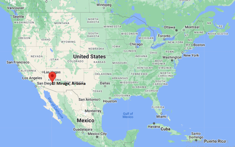
El Mirage Map, Arizona, USA
Where is El Mirage?: The Google Map showing the location of El Mirage in the U.S. state of Arizona.
Where is El Mirage Located?
El Mirage is a city located in the Maricopa County of Arizona, United States. El Mirage lies between 36.0526 Degrees North latitudes and 90.4887 Degrees West longitudes. According to 2020 U.S.census, the population of El Mirage city is 35805 people and the city has a total area of 9.9 sq mi. The city has numerous parks and recreational facilities.
Most Viewed US Maps
| USA Sttae Map | USA Region Map | USA Road Map |
| USA County Map | Where is USA in World Map? | US ZIP Code Map |
| USA Time Zones Map | US State and Capitals Map | USA Physical Map |
Find 4,400+ U.S. Cities by State - Explore Their Locations and Get Detailed Information
El Mirage, Arizona Quick Facts
| Property | Details |
|---|---|
| City | El Mirage |
| County | Maricopa County |
| State | Arizona |
| State Capital | Phoenix |
| US Region | West |
| Latitude | 33.6131°N |
| Longitude | 112.3246°W |
| Elevation | 1,142 ft (348 m) |
| Land Area | 10.13 sq mi |
| Water Area | 0.00 sq mi |
| Total Area | 10.13 sq mi |
| Population (2020 Census) | 35,805 |
| Population Density | Approximately 3,535 per sq mi |
| ZIP Code | 85335 |
| Area Code | 623 |
| Time Zone Standard | Mountain Standard Time (MST), UTC−7 |
| Time Zone Daylight | Arizona does not observe Daylight Saving Time |
| Currency | US Dollar (USD) |
| FIPS Code | 04-22140 |
| Congressional District | Arizona's 8th Congressional District |
Nearby Cities to El Mirage, Arizona
- Surprise, Arizona - West - 3 mi
- Sun City, Arizona - East - 4 mi
- Youngtown, Arizona - Southeast - 4 mi
- Peoria, Arizona - East - 8 mi
- Glendale, Arizona - Southeast - 12 mi
- Litchfield Park, Arizona - South - 13 mi
- Goodyear, Arizona - South - 18 mi
- Avondale, Arizona - South - 17 mi
- Phoenix, Arizona - Southeast - 23 mi
- Buckeye, Arizona - Southwest - 28 mi
El Mirage, Arizona Climate and Weather Overview
| Month | Avg High (°F) | Avg Low (°F) | Avg Rainfall (in) |
|---|---|---|---|
| January | 67 | 43 | 0.90 |
| April | 87 | 58 | 0.20 |
| July | 106 | 82 | 1.00 |
| October | 91 | 64 | 0.60 |
| Annual | 89 | 62 | 8.20 |
| Climate Attribute | Details |
|---|---|
| Climate Classification (Köppen) | Hot Desert (BWh) |
| Annual Rainfall | Approximately 8 inches |
| Annual Sunshine Days | About 299 days |
| Hurricane/Tornado Risk | Very low hurricane risk; very low tornado risk |
| Snowfall | Rare (0 inches annually) |
Driving Distances from El Mirage, Arizona
| City | State | Distance (mi) | Approx. Drive Time |
|---|---|---|---|
| Surprise | Arizona | 3 | 8 min |
| Sun City | Arizona | 4 | 10 min |
| Youngtown | Arizona | 4 | 10 min |
| Peoria | Arizona | 8 | 15 min |
| Glendale | Arizona | 12 | 20 min |
| Litchfield Park | Arizona | 13 | 22 min |
| Avondale | Arizona | 17 | 25 min |
| Goodyear | Arizona | 18 | 25 min |
| Phoenix | Arizona | 23 | 35 min |
| Buckeye | Arizona | 28 | 35 min |
Transportation and Connectivity in El Mirage, Arizona
| Transportation | Details |
|---|---|
| Airport Name | Phoenix Sky Harbor International Airport |
| IATA Code | PHX |
| Port | None |
| Major Highways | U.S. Route 60 (Grand Avenue), Loop 303, Loop 101, Interstate 10 (nearby) |
| Train/Amtrak Service | Nearest Amtrak station is in Maricopa, Arizona |
| Local Bus/Transit Service | Valley Metro Bus |
- U.S. Route 60 (Grand Avenue) is the primary transportation corridor connecting El Mirage with Phoenix and northwestern Arizona.
- Loop 303 and Loop 101 provide quick access to neighboring suburbs and the greater Phoenix metropolitan area.
- Valley Metro Bus routes connect residents with nearby cities including Surprise, Glendale, Peoria, and Phoenix.
- Phoenix Sky Harbor International Airport, about 30 miles southeast, offers extensive domestic and international flight services.
Places to Visit in El Mirage, Arizona
| Landmark Name | Type |
|---|---|
| Gateway Park | Community Park |
| El Mirage Dry Lake OHV Area | Off-Road Recreation Area |
| Surprise Community Park | Regional Park |
| Wildlife World Zoo, Aquarium & Safari Park | Zoo |
| White Tank Mountain Regional Park | Regional Park |
| Surprise Stadium | Sports Venue |
| Northwest Regional Library | Library |
| Rio Vista Community Park | Community Park |
| Desert Diamond Arena | Entertainment Venue |
| Sahuaro Ranch Park | Historic Park |
Colleges and Universities in El Mirage, Arizona
| Institution Name | Type | Level | Notable For |
|---|---|---|---|
| Ottawa University Arizona | Private | University | Business, education, and health sciences |
| Estrella Mountain Community College | Public | Community College | Transfer and workforce education |
| Glendale Community College | Public | Community College | Academic transfer and career programs |
| Arizona State University West Valley Campus | Public | University | Liberal arts and interdisciplinary studies |
| Midwestern University | Private | University | Health sciences and medical education |
| Grand Canyon University | Private | University | Business, education, and nursing |
| Arizona Christian University | Private | University | Liberal arts and ministry |
| Dysart Unified School District | Public | K–12 District | Primary and secondary education |
Waterbodies in El Mirage, Arizona
New River, Agua Fria River, Lake Pleasant, Beardsley Canal, Arizona Canal, Thunderbird Conservation Park Lake, Rio Vista Pond, Lake Pleasant Regional Park Reservoir
Golf Courses in El Mirage, Arizona
Grandview Golf Course, Coyote Lakes Golf Club, The Legacy Golf Club at Granite Falls, Desert Springs Golf Club, Sun Village Golf Course, Pebblebrook Golf Course, Cimarron Golf Club, Riverview Golf Course
El Mirage, Arizona — Key Historical Facts
- El Mirage began as a small farming community in the 1930s, supported by irrigation projects that made agriculture possible in the Sonoran Desert.
- The city experienced gradual residential growth after World War II as the Phoenix metropolitan area expanded westward.
- El Mirage was officially incorporated as a city in 1951 and has steadily developed into a suburban community.
- Improved transportation corridors, including U.S. Route 60 and nearby Loop 303, encouraged commercial and residential development in the late 20th century.
- The city's economy has diversified from agriculture to include retail, light industry, logistics, and service businesses.
- Today, El Mirage is known for its family-friendly neighborhoods, year-round sunshine, convenient location in the West Valley, and easy access to recreational attractions across the Phoenix metropolitan area.
References
Arizona Related Links
- Where is Anthem
- Where is Apache Junction
- Where is Avondale
- Where is Benson
- Where is Bullhead City
- Where is Casa Grande
- Where is Casas Adobes
- Where is Catalina Foothills
- Where is Douglas
- Where is Drexel Heights
- Where is El Mirage
- Where is Eloy
- Where is Flagstaff
- Where is Florence
- Where is Flowing Wells
- Where is Fort Mohave
- Where is Fortuna Foothills
- Where is Fountain Hills
- Where is Glendale
- Where is Globe
- Where is Goodyear
- Where is Green Valley
- Where is Guadalupe
- Where is Kingman
- Where is Lake Havasu City
- Where is Litchfield Park
- Where is Marana
- Where is Maricopa
- Where is New River
- Where is Nogales
- Where is Oro Valley
- Where is Page
- Where is Payson
- Where is Peoria
- Where is Prescott
- Where is Prescott Valley
- Where is Queen Creek
- Where is Rio Rico
- Where is Sahuarita
- Where is San Luis
- Where is San Tan Valley
- Where is Sierra Vista
- Where is Snowflake
- Where is Sun City
- Where is Sun City West
- Where is Sun Lakes
- Where is Surprise
- Where is Tanque Verde
- Where is Tempe
- Where is Thatcher
- Where is Tolleson
- Where is Valencia West
- Where is Wickenburg
- Where is Youngtown
- Where is Yuma