
Where is Harrison Located? - Harrison is a city located in the Allegheny County of New York, United States. Harrison lies between 60.5360118 Degrees North latitudes and 150.7943244 Degrees West longitudes.
Location Map of Harrison, New York
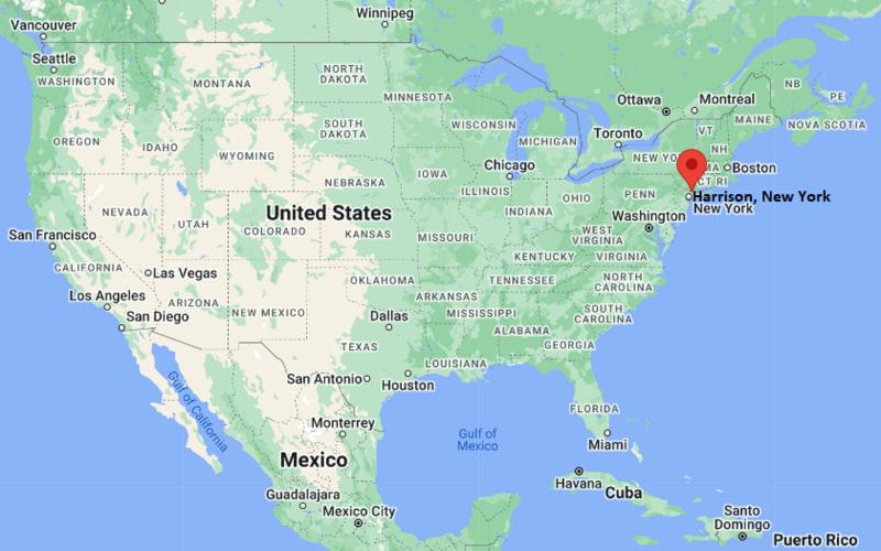
Harrison Map, New York, USA
Where is Harrison?: The Google Map showing the location of Harrison in the U.S. state of New York.
Where is Harrison Located?
Harrison is a city located in the Allegheny County of New York, United States. Harrison lies between 60.5360118 Degrees North latitudes and 150.7943244 Degrees West longitudes. According to 2020 U.S.census, the population of Harrison city is 28218 people and the city has a total area of 16.76 sq mi. The city has numerous parks and recreational facilities.
Most Viewed US Maps
| USA Sttae Map | USA Region Map | USA Road Map |
| USA County Map | Where is USA in World Map? | US ZIP Code Map |
| USA Time Zones Map | US State and Capitals Map | USA Physical Map |
Find 4,400+ U.S. Cities by State - Explore Their Locations and Get Detailed Information
Harrison, New York Quick Facts
| Property | Information |
|---|---|
| Town | Harrison |
| County | Westchester County |
| State | New York |
| State Capital | Albany |
| US Region | Northeastern United States |
| Latitude | 40.9704°N |
| Longitude | 73.7126°W |
| Elevation | 82 ft (25 m) |
| Land Area | 16.83 sq mi |
| Water Area | 0.44 sq mi |
| Total Area | 17.27 sq mi |
| Population (latest Census year) | 28,943 (Census 2020) |
| Population Density | Approximately 1,720 per sq mi |
| ZIP Codes | 10528, 10604 |
| Area Code | 914 |
| Time Zone Standard | Eastern Standard Time (EST, UTC−5) |
| Time Zone Daylight | Eastern Daylight Time (EDT, UTC−4) |
| Currency | US Dollar (USD) |
| FIPS Code | 36-33013 |
| Congressional District | New York's 16th Congressional District |
Nearby Cities to Harrison, New York
- White Plains, New York — 3 mi North
- Rye, New York — 3 mi South
- Mamaroneck, New York — 4 mi Southwest
- Port Chester, New York — 5 mi East
- Scarsdale, New York — 6 mi West
- New Rochelle, New York — 8 mi Southwest
- Greenwich, Connecticut — 8 mi East
- Mount Vernon, New York — 12 mi Southwest
- Yonkers, New York — 17 mi West
- New York City, New York — 27 mi South
Driving Distances from Harrison, New York
| City | State | Distance (mi) | Approx. Drive Time |
|---|---|---|---|
| White Plains | New York | 3 | 8 minutes |
| Rye | New York | 3 | 8 minutes |
| Mamaroneck | New York | 4 | 10 minutes |
| Port Chester | New York | 5 | 12 minutes |
| Scarsdale | New York | 6 | 15 minutes |
| New Rochelle | New York | 8 | 18 minutes |
| Greenwich | Connecticut | 8 | 18 minutes |
| Yonkers | New York | 17 | 30 minutes |
| Stamford | Connecticut | 18 | 30 minutes |
| New York City | New York | 27 | 45 minutes |
Transportation and Connectivity in Harrison, New York
| Transportation | Details |
|---|---|
| Airport Name | Westchester County Airport |
| IATA Code | HPN |
| Port | Port of New York and New Jersey (regional) |
| Major Highways | Interstate 287, Hutchinson River Parkway, Interstate 95 (nearby), U.S. Route 1 (nearby) |
| Train/Amtrak Service | Metro-North Railroad (Harrison Station); nearest Amtrak station at New Rochelle |
| Local Bus/Transit Service | Bee-Line Bus System |
- Interstate 287 connects Harrison with White Plains, Tarrytown, and Connecticut.
- Hutchinson River Parkway provides convenient access to the Bronx and southern Westchester County.
- Metro-North Railroad's New Haven Line serves Harrison Station with direct commuter rail service to Grand Central Terminal in Manhattan.
- Westchester County Airport is about 5 miles north and offers domestic commercial flights.
- Bee-Line buses and nearby Amtrak service at New Rochelle provide additional regional transportation options.
What are top Places to Visit in Harrison, New York
| Landmark Name | Type |
|---|---|
| Westchester Country Club | Historic Country Club |
| Silver Lake Preserve | Nature Preserve |
| Harrison Meadows Country Club | Golf & Recreation Club |
| Dow's Lane Historic District | Historic Area |
| Playland Park | Amusement Park |
| Marshlands Conservancy | Nature Preserve |
| Rye Nature Center | Nature Center |
| Kensico Dam Plaza | Historic Landmark |
| Capitol Theatre | Performing Arts Venue |
| Untermyer Gardens Conservancy | Historic Garden |
Colleges and Universities in Harrison, New York
| Institution | Type | Level | Notable For |
|---|---|---|---|
| Purchase College, State University of New York | Public | University | Performing arts, visual arts, liberal arts, and sciences |
| Manhattanville University | Private | University | Liberal arts, business, education, and graduate studies |
| Fordham University – Westchester Campus | Private | University | Graduate business, education, and professional programs |
| Westchester Community College | Public | Community College | Associate degrees, workforce development, and transfer programs |
| Mercy University | Private | University | Business, healthcare, education, and liberal arts |
Waterbodies in Harrison, New York
Long Island Sound, Blind Brook, Beaver Swamp Brook, Mamaroneck River, Byram River, Silver Lake, Rye Lake, Kensico Reservoir, Echo Bay, Milton Harbor
Golf Courses in Harrison, New York
Westchester Country Club, Harrison Meadows Country Club, Apawamis Club, Fenway Golf Club, Sunningdale Country Club, Hampshire Country Club, Quaker Ridge Golf Club, Wykagyl Country Club
Harrison, New York — Key Historical Facts
- Harrison was established in 1696 when John Harrison purchased approximately 24 square miles of land from local Native American groups.
- The town officially became part of Westchester County in 1788 and developed as a farming community before transitioning into a suburban residential area.
- The arrival of the railroad in the nineteenth century encouraged residential growth and strengthened Harrison's connection with New York City.
- During the twentieth century, Harrison became home to major corporate headquarters, educational institutions, and upscale residential neighborhoods.
- Today, Harrison is known for its excellent schools, corporate campuses, country clubs, convenient commuter rail access, and high quality of life within the New York metropolitan area.
References
New York Maps and Info
| New York Map | Counties in New York | Cities in New York |
| New York Zipcodes | Airports in New York | US Zip code Map |
| New York Area Codes | New York River Map | - |
- Where is Albany
- Where is Auburn
- Where is Baldwin
- Where is Bay Shore
- Where is Binghamton
- Where is Brentwood
- Where is Brighton
- Where is Centereach
- Where is Central Islip
- Where is Cheektowaga
- Where is Commack
- Where is Copiague
- Where is Coram
- Where is Deer Park
- Where is Dix Hills
- Where is East Massapequa
- Where is East Meadow
- Where is East Patchogue
- Where is Eastchester
- Where is Elmira
- Where is Elmont
- Where is Franklin Square
- Where is Freeport
- Where is Garden City
- Where is Glen Cove
- Where is Harrison
- Where is Hempstead
- Where is Hicksville
- Where is Holbrook
- Where is Huntington
- Where is Huntington Station
- Where is Irondequoit
- Where is Ithaca
- Where is Jamestown
- Where is Kingston
- Where is Kiryas Joel
- Where is Lackawanna
- Where is Levittown
- Where is Lindenhurst
- Where is Lockport
- Where is Lynbrook
- Where is Mamaroneck
- Where is Massapequa
- Where is Medford
- Where is Merrick
- Where is Middletown
- Where is Mineola
- Where is Monsey
- Where is Mount Vernon
- Where is New City
- Where is New Rochelle
- Where is Newburgh
- Where is Niagara Falls
- Where is North Bellmore
- Where is North Tonawanda
- Where is Oceanside
- Where is Ossining
- Where is Peekskill
- Where is Plainview
- Where is Port Chester
- Where is Poughkeepsie
- Where is Rockville Centre
- Where is Rome
- Where is Rotterdam
- Where is Saratoga Springs
- Where is Schenectady
- Where is Selden
- Where is Shirley
- Where is Smithtown
- Where is Spring Valley
- Where is Syracuse
- Where is Troy
- Where is Uniondale
- Where is Utica
- Where is Valley Stream
- Where is Watertown
- Where is West Babylon
- Where is West Hempstead
- Where is West Islip
- Where is West Seneca
- Where is White Plains
- Where is Yonkers