
Where is Monsey Located? - Monsey is a city located in the Rockland County of New York, United States. Monsey lies between 64.8058544 Degrees North latitudes and 147.4100404 Degrees West longitudes.
Location Map of Monsey, New York
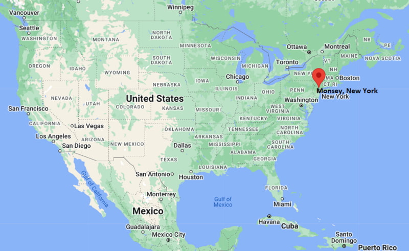
Monsey Map, New York, USA
Where is Monsey?: The Google Map showing the location of Monsey in the U.S. state of New York.
Where is Monsey Located?
Monsey is a city located in the Rockland County of New York, United States. Monsey lies between 64.8058544 Degrees North latitudes and 147.4100404 Degrees West longitudes. According to 2020 U.S.census, the population of Monsey city is 26954 people and the city has a total area of 2.27 sq mi. The city has numerous parks and recreational facilities.
Most Viewed US Maps
| USA Sttae Map | USA Region Map | USA Road Map |
| USA County Map | Where is USA in World Map? | US ZIP Code Map |
| USA Time Zones Map | US State and Capitals Map | USA Physical Map |
Find 4,400+ U.S. Cities by State - Explore Their Locations and Get Detailed Information
Monsey, New York Quick Facts
| Attribute | Information |
|---|---|
| City | Monsey (Census-Designated Place) |
| County | Rockland County |
| State | New York |
| State Capital | Albany |
| US Region | Middle Atlantic (Northeastern United States) |
| Latitude | 41.1112° N |
| Longitude | 74.0688° W |
| Elevation | 440 ft (134 m) |
| Land Area | 4.38 sq mi |
| Water Area | 0.02 sq mi |
| Total Area | 4.40 sq mi |
| Population (2020 Census) | 27,762 |
| Population Density | Approximately 6,338 per sq mi |
| ZIP Codes | 10952 |
| Area Code | 845 |
| Time Zone Standard | Eastern Standard Time (EST, UTC−5) |
| Time Zone Daylight | Eastern Daylight Time (EDT, UTC−4) |
| Currency | United States Dollar (USD) |
| FIPS Code | 36-48374 |
| Congressional District | New York's 17th Congressional District |
Transportation and Connectivity in Monsey
| Category | Information |
|---|---|
| Airport Name | Westchester County Airport (nearest regional airport) |
| IATA Code | HPN |
| Port | Port of New York and New Jersey (regional access) |
| Major Highways | New York State Route 59, New York State Route 306, Palisades Interstate Parkway (nearby), Interstate 87/New York State Thruway (nearby) |
| Train/Amtrak Service | Nearby NJ Transit service at Spring Valley; nearest Amtrak station is Yonkers |
| Local Bus/Transit Service | Transport of Rockland (TOR) and Hudson Link |
- New York State Route 59 – Main commercial corridor connecting Monsey with Nanuet, Spring Valley, and Suffern.
- New York State Route 306 – North–south route linking Monsey with New Hempstead and Hillburn.
- Palisades Interstate Parkway – Nearby scenic highway providing direct access to New York City and Bear Mountain.
- Interstate 87 (New York State Thruway) – Major interstate connecting the region with Albany, New York City, and upstate New York.
Top Places to Visit in Monsey, New York
| Landmark Name | Type |
|---|---|
| Kakiat Park | County Park |
| Harriman State Park | State Park |
| Palisades Interstate Park | State Park |
| Rockland Bakery | Local Attraction |
| Spring Valley Marketplace | Shopping Area |
| Kennedy Dells Park | Park |
| Rockland Lake State Park | State Park |
| Bear Mountain State Park | State Park |
| Monsey Glen Park | Neighborhood Park |
| The Shops at Nanuet | Shopping Center |
Driving Distances from Monsey, New York to Nearby Cities
| City | State | Distance (mi) | Approx. Drive Time |
|---|---|---|---|
| Spring Valley | New York | 2 | 5 minutes |
| Nanuet | New York | 5 | 10 minutes |
| Suffern | New York | 6 | 15 minutes |
| Pearl River | New York | 8 | 15 minutes |
| White Plains | New York | 23 | 35 minutes |
| Paterson | New Jersey | 19 | 30 minutes |
| Hackensack | New Jersey | 24 | 35 minutes |
| Newark | New Jersey | 35 | 45 minutes |
| New York City | New York | 34 | 50 minutes |
| Poughkeepsie | New York | 53 | 1 hour 10 minutes |
Colleges and Universities in Monsey, New York
| Institution Name | Type | Level | Notable For |
|---|---|---|---|
| Rockland Community College | Public | Community College | Associate degrees and workforce programs |
| SUNY Orange | Public | Community College | Transfer and career education |
| Yeshiva University | Private | University | Jewish studies and professional programs |
| Pace University – Westchester Campus | Private | University | Business and professional studies |
| St. Thomas Aquinas College | Private | College | Liberal arts and business education |
Waterbodies in Monsey, New York
Ramapo River, Lake Welch, Rockland Lake, Lake Tiorati, Lake Sebago, Stahahe Brook, Minisceongo Creek, Lake Wanoka.
Stadiums in Monsey
Rockland Community College Fieldhouse, RCC Soccer Field, Clover Stadium, Bear Mountain Ice Rink, Palisades Credit Union Park.
Monsey, New York — Key Historical Facts
- Monsey developed from early farming settlements in the Ramapo Valley and grew as transportation routes expanded through Rockland County.
- The community was named after the Munsee branch of the Lenape Native American people who historically inhabited the region.
- The arrival of rail transportation in the nineteenth century helped connect Monsey with nearby communities and larger markets.
- Monsey experienced significant residential growth during the twentieth century as part of the suburban expansion of the New York metropolitan area.
- Today, Monsey is known for its diverse community, proximity to parks and natural areas, and its location within the greater Hudson Valley region.
References
- Rockland County Government
- Town of Ramapo
- U.S. Census Bureau
- Rockland Community College
- I LOVE NY – New York Tourism
New York Maps and Info
| New York Map | Counties in New York | Cities in New York |
| New York Zipcodes | Airports in New York | US Zip code Map |
| New York Area Codes | New York River Map | - |
- Where is Albany
- Where is Auburn
- Where is Baldwin
- Where is Bay Shore
- Where is Binghamton
- Where is Brentwood
- Where is Brighton
- Where is Centereach
- Where is Central Islip
- Where is Cheektowaga
- Where is Commack
- Where is Copiague
- Where is Coram
- Where is Deer Park
- Where is Dix Hills
- Where is East Massapequa
- Where is East Meadow
- Where is East Patchogue
- Where is Eastchester
- Where is Elmira
- Where is Elmont
- Where is Franklin Square
- Where is Freeport
- Where is Garden City
- Where is Glen Cove
- Where is Harrison
- Where is Hempstead
- Where is Hicksville
- Where is Holbrook
- Where is Huntington
- Where is Huntington Station
- Where is Irondequoit
- Where is Ithaca
- Where is Jamestown
- Where is Kingston
- Where is Kiryas Joel
- Where is Lackawanna
- Where is Levittown
- Where is Lindenhurst
- Where is Lockport
- Where is Lynbrook
- Where is Mamaroneck
- Where is Massapequa
- Where is Medford
- Where is Merrick
- Where is Middletown
- Where is Mineola
- Where is Monsey
- Where is Mount Vernon
- Where is New City
- Where is New Rochelle
- Where is Newburgh
- Where is Niagara Falls
- Where is North Bellmore
- Where is North Tonawanda
- Where is Oceanside
- Where is Ossining
- Where is Peekskill
- Where is Plainview
- Where is Port Chester
- Where is Poughkeepsie
- Where is Rockville Centre
- Where is Rome
- Where is Rotterdam
- Where is Saratoga Springs
- Where is Schenectady
- Where is Selden
- Where is Shirley
- Where is Smithtown
- Where is Spring Valley
- Where is Syracuse
- Where is Troy
- Where is Uniondale
- Where is Utica
- Where is Valley Stream
- Where is Watertown
- Where is West Babylon
- Where is West Hempstead
- Where is West Islip
- Where is West Seneca
- Where is White Plains
- Where is Yonkers